


All Files > Page 1637
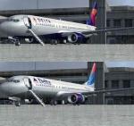
Boeing 737-800 Delta Airlines Twin Pack with Advanced VC
(Category: FSX > Civil Jets)
32.39Mb (13320 downloads)
Boeing 737-800 Delta Airlines 2007 and Detla Air Lines NNC Winglet N3757D with advanced VC
for Microsoft Flight Simulator X
Skyspirit/Project Opensky native FSX Boeing 737-800 model.
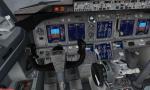
Upgraded to FSX using Alrot's revised Boeing 737-800 VC. This model includes Working wipers (right mouse click on switch) with rain effect. Switches for LCD Screens, EICAS, PFD, MFT. Autobrake switch. Opening pilots window. Cabin Lights switch. Realistic FMC. Ground Proximity Warning System (GPWS), More Realistic night textures.
FSX native model winglet by Skyspirit/Project Opensky.
Textures by Project Opensky team members.
Modified for FSX by Chris Evans.
Posted Aug 24, 2012 05:03 by chris evans
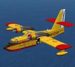
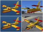
FSX Canadair CL-215 Ejercito del Aire (Spain) Textures
(Category: FSX > Military)
3.34Mb (3851 downloads)
Textures for the FSX Canadair CL-215 Ejercito del Aire (Spain Air Force). 2 versions. Full model by Massimo Taccoli required.
Required files:
required file
Posted Aug 23, 2012 23:59 by Enrique Medal
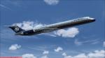
Jet City MD-82 Aeromexico Baremetal Textures
(Category: FS2004 > Payware)
4.93Mb (632 downloads)
Aeromexico bare metal textures only for the payware Jet City MD-82
Posted Aug 23, 2012 17:33 by LUIS CASTRO
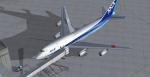
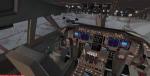
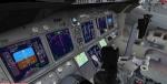
Boeing 747-451 All Nippon Airways New Color JA405A with Advanced VC
(Category: FSX > Civil Jets)
29.04Mb (5984 downloads)
SkySpirit 2011 - Boeing 747-451
ANA - All Nippon Airways New Color JA405A with Enhanced VC
Skyspirit FSX native Boeing 747-400 passenger model upgraded using the vastly improved Boeing 747 VC from Alejandro Rojas Lucena/FSND (See panel docs for details). VC includes FMC, EICAS, MFD with control panel, GPWS, working wipers, cabin lights, fire suppression, avionics switch, fuel crossfeed, landing lights switches, taxi light switch, engine generators, APU generator, battery switch, starter switches, de-ice switch, general lights switches. Beautiful Skyspirit 747-800 passenger model with complex features and ground service vehicles (press shift e 2, shift e 3, etc. ). Textures by Project Opensky member.
Also includes the Boeing 747 VC textures upgrade by Jason A. Lee. This give a much clearer 747 interior virtual cockpit look.
Assembled and edited for FSX by Chris Evans.
Posted Aug 23, 2012 15:14 by chris evans
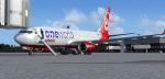
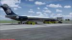
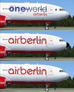
Boeing 737-800w Air Berlin - Oneworld-cs with Advanced VC
(Category: FSX > Civil Jets)
19.98Mb (5430 downloads)
Boeing 737-800w Air Berlin - Oneworld-cs
for Microsoft Flight Simulator X
Skyspirit/Project Opensky native FSX Boeing 737-800 model.
Upgraded to FSX using Alrot's revised Boeing 737-800 VC. This model includes Working wipers (right mouse click on switch) with rain effect. Switches for LCD Screens, EICAS, PFD, MFT. Autobrake switch. Opening pilots window. Cabin Lights switch. Realistic FMC. Ground Proximity Warning System (GPWS), More Realistic night textures.
FSX native model winglet by Skyspirit/Project Opensky.
High quality textures by Mathieu Vos.
Modified for FSX by Chris Evans.
Posted Aug 23, 2012 14:43 by chris evans
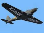
Fairey Battle MK1
(Category: FS2004 > Vintage)
6.41Mb (1438 downloads)
FS2004. Fairey Battle MK1
A Light bomber replacement for the Hawker
Hart. First flight was the 10th. March 1936.
Aircraft of No. 52 Squadron based at Abingdon
in late 1937. - 4:1 panel added and minor
Flight Dynamics fixes.
v2 By Edward Cook.
Posted Aug 23, 2012 14:02 by edward cook
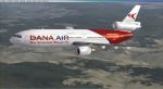
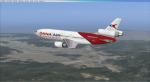
DC-10-40D Dana Air Textures
(Category: FSX > Civil Jets)
11.20Mb (2769 downloads)
Dana Air DC-10-40D V1, registration number 5N-SRS, repaint for the Thomas Ruth + Eric Cantu McDonnell Douglas DC-10 PackageV2. Textures only requires Thomas Ruth + Eric Cantu McDonnell Douglas DC-10 PackageV2..
Required files:
required file
Posted Aug 23, 2012 09:11 by T.Marson
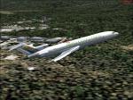
Aero Costa Rica Boeing 727
(Category: FS2004 > Civil Jets)
18.76Mb (2157 downloads)
FS2004 Boeing 727 Aero Costa Rica. Model by Vistaliners.
Posted Aug 22, 2012 13:11 by Donald Montero
Airbus A330-200 Air Berlin 3 Liveries Package
(Category: FSX > Civil Jets)
49.30Mb (10996 downloads)
Thomas Ruth Airbus A330-200 Air Berlin Package for FSX.
Fixed Textures!
Includes 3 different liveries and VC.
D-ABXA (one world)
D-ALPH (normal)
D-ALPO (black nose)
Paints by JimFly
Posted Aug 22, 2012 12:30 by Jim Fly
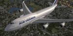
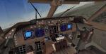
Boeing 747-400 GE CF6 Air France with Enhanced VC
(Category: FSX > Civil Jets)
31.77Mb (6090 downloads)
SkySpirit 2011 - Boeing 747-400 GE CF6
Air France with Enhanced VC
Skyspirit FSX native Boeing 747-400 passenger model upgraded using the vastly improved Boeing 747 VC from Alejandro Rojas Lucena/FSND (See panel docs for details). VC includes FMC, EICAS, MFD with control panel, GPWS, working wipers, cabin lights, fire suppression, avionics switch, fuel crossfeed, landing lights switches, taxi light switch, engine generators, APU generator, battery switch, starter switches, de-ice switch, general lights switches. Beautiful Skyspirit FSX 747-400 passenger model with complex features and ground service vehicles (press shift e 2, shift e 3, Ctrl J for jetway, etc. ). Textures by Project Opensky member.
Also includes the Boeing 747 VC textures upgrade by Jason A. Lee. This give a much clearer 747 interior virtual cockpit look.
Assembled and edited for FSX by Chris Evans.
Zip preview for larger pictures.
See panel docs and images for VC details and controls!
Posted Aug 22, 2012 05:43 by chris evans