


All Files > Page 1922
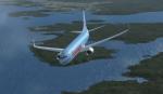
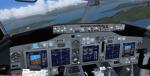
Boeing 737-800 Thomson Airways
(Category: FSX > Civil Jets)
13.34Mb (6545 downloads)
Boeing 737-800 Thomson Airways package with VC. Model by Project Opensky. Thomson textures by Svante Fagerstrom. Thomson Airways is a large UK based charter airline, offering scheduled and charter flights from the UK to destinations across Europe, Africa, Asia and North America. The company commenced operations on 1 November 2008, following the merger and subsequent re-branding of Thomsonfly and First Choice Airways. Configured for FSX with VC, by Chris Evans.
Posted Aug 6, 2011 15:07 by Chris Evans
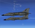
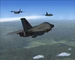
FSX F-111 AI aircraft for Australia
(Category: FSX > Military)
13.08Mb (4423 downloads)
FSX F-111 AI aircraft for Australia.Boosts F-111 activity level.
This AI package adds 11 extra F-111s to the Australian skies.Specifically
8 AI aircraft at RAAF Amberley airbase (YAMB) and 3 at RAAF East SAle (YMES).
AMberley now comes to life,these F-111 AI function with, and complement
the OZx ADF AI for FSX.Some AI travel about the Eastern seaboard of Australia.
4-1SQN, 4-6SQN,3-ARDU.Includes AI timetable.
By Karol Chlebowski
Posted Aug 6, 2011 08:02 by Karol Chlebowski
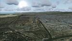
Coro Airport (SVCR) - Venezuela
(Category: FSX > Scenery)
39.83Mb (1217 downloads)
National airport located in the city of Coro, capital of Falcon state, in western Venezuela. With photo-terrain scenery from satellite imagery in Google Earth.
Not compatible with versions prior to FSX.
This scenery includes terminal building and hangars with realistic textures from images obtained from Internet.
Also includes a friendly Auto-Install.
Required files:
required file
Posted Aug 5, 2011 10:50 by David Maldonado
Fokker 100 Package
(Category: FSX > Civil Jets)
9.41Mb (21472 downloads)
The Fokker 100 is a 107 seat, twin jet, regional airliner which first
went into airline operation in 1988 and is still in service all over the world.
The Fokker 100 is a good design, popular with passengers and airlines,
but was not a great commercial success for Fokker due to high production
costs and increasing competition in the regional airliner market from
the likes of Bombardier and Embraer. Production ceased in 1997 after 283
had been delivered.
Full package for FSX/SP2, with custom panel and VC with FMC. 3D passenger cabin,
animated airstair and cargo doors, airbrakes and reverse thrust. Kneeboard check
and ref lists included. Four liveries. Realistic performance and pleasant hand flying qualities.
By Jean-Pierre Brisard and Bob May - Premier Aircraft Design. More liveries and paint kit available on the PAD web site.
Posted Aug 5, 2011 07:23 by Bob May (PAD)

Fokker 100 Package
(Category: FS2004 > Civil Jets)
7.97Mb (10662 downloads)
The Fokker 100 is a 107 seat, twin jet, regional airliner which first
went into airline operation in 1988 and is still in service all over the world.
The Fokker 100 is a good design, popular with passengers and airlines,
but was not a great commercial success for Fokker due to high production
costs and increasing competition in the regional airliner market from
the likes of Bombardier and Embraer. Production ceased in 1997 after 283
had been delivered.
Full package for FS2004, with custom panel and VC 3D passenger cabin,
animated airstair and cargo doors, airbrakes and reverse thrust. Kneeboard check
and ref lists included. Four liveries. Realistic performance and pleasant hand flying qualities.
By Jean-Pierre Brisard and Bob May - Premier Aircraft Design
More liveries and paint kit available on the PAD web site.
Posted Aug 5, 2011 07:13 by Bob May (PAD)
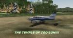

Mystery Temple of Coo-Lon
(Category: FSX > Missions)
8.68Mb (6158 downloads)
The jungle of Venezuela is full of mysteries but there is a place that hardly anyone goes due to the remoteness of it and the many legends of the "Curse of the twin snakes". Its is said that many who have been there have had scales under their feet some two months later!!!!..so it is a lonely place. Will you fly there and challenge the curse??? scales do not fit well under your toes you know...well give it a try, see the jungle and admire the temple and forget the curse..if you dare....
Posted Aug 5, 2011 01:29 by Gera Godoy Canova
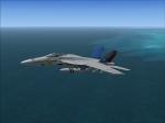
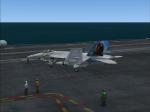
VRS Superbug VFA-82 Marauders CAG Textures
(Category: FSX > Payware)
2.48Mb (336 downloads)
VRS Superbug VFA-82 Marauders CAG textures. Requires the payware VRS Superbug. Repaint by Hornet202
Posted Aug 4, 2011 12:48 by Chris Hammons
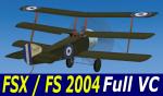
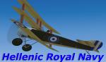
FSX/FS2004 Sopwith Triplane Hellenic Royal Navy Package
(Category: FSX > Vintage)
7.13Mb (4534 downloads)
FSX/FS2004 Sopwith Triplane Hellenic Royal Navy package.
I had many requests for this and i hope it didnt take long
There are not that many fs triplane models especialy for FSX.After a lot of research i had to make this plane fly in the fsx world and this is what came out.There are no specific information or photos from the WWI period for this aircraft from the Hellenic Navy Air Service or how many planes wore the Hellenic colors ,other than it flew with the Greek/French Squadrons with overpainted markings.The repaint is based on information from the Hellenic archives and compaired with other Hellenic Royal Navy aircraft that flew with theese Squadrons at the time.This is a complete package featuring Moving parts Full VC, 2D panel and sound.The package is made available after personal permition from the original author Mr.Frank Elton. Many thanks Frank !!!
Modified textures repacking for FSX & repaint for the Hellenic colors by:Yiannis Katehis Tsetsas
Posted Aug 3, 2011 20:56 by YIANNIS KATEHIS TSETSAS
RQ-4 Panel Update
(Category: FSX > Military)
2.64Mb (3158 downloads)
A update to the Rq-4 panel. Changed a few guage made it better overall enojy.
Required files:
required file
Posted Aug 3, 2011 19:36 by Robert Wahrenbrock
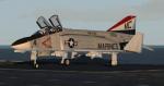
FS2004/ FSX F-4B Phantom II US Marines Textures
(Category: FS2004 > Military)
14.10Mb (2032 downloads)
Textures for the Alphasim/Virtuavia F-4B Phantom II for FS2004. This folder contains textures only for a US MARINES McDonnell Douglas F-4B Phantom II, number 153006, of MARINE Air Reserve Squadron VMFA-351, Atlanta, Georgia circa 1976. These textures have been created specifically for Pack I, "model 2", and "model 3"; and Pack II, "model", for which I have included config entries.
Posted Aug 3, 2011 11:58 by michael litze (uploader)