


All Files > Page 1920
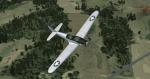
Fairchild PT-19B
(Category: FSX > Vintage)
18.91Mb (6831 downloads)
FSX SP-2 Acceleration
Fairchild PT-19B
WW2 USAAF Basic Training Aircraft. The Fairchild PT-19 (company designation Fairchild M62) was an American Fairchild Aircraft monoplane primary trainer aircraft that served with the United States Army Air Forces, RAF and RCAF during World War II. It was a contemporary of the Kaydet biplane trainer and was used by the USAAF during Primary Flying Training as the introductory pre-solo phase trainer for introducing new pilots to flying before passing them on to the more agile Kaydet. As with other USAAF trainers of the period, the PT-19 had multiple designations based on the power plant installed. By Tim Conrad
This release comes with multiple paint schemes, and fore and aft cockpit VC's.
Paint Kit included
Posted Aug 10, 2011 11:25 by michael litze (uploader)
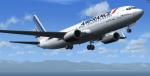
FSX Air France B737-800 Package
(Category: FSX > Civil Jets)
55.05Mb (8307 downloads)
FSX Air France B737-800
Updated to work in FSX by Chris Evans using the FSX default B737-800 VC and panel.
Custom 737 sounds.
This Boeing 737-800 Air France repaint featurng calssic photo real tail with new
Air France Logo in front. Giving this aircraft more realastic shadow, shine and
reflective effects. Featuring 32bit Highly Detailed graphics with night light effects,
the model includes all the usual things as a steering nose wheel, taxi and landing
lights, dynamics shine and all moving parts, including a fully animated landing gear
animation. Some special things include three opening doors, with visible interior.
Flexing wings, wing views and trim animation for the horizontal stabilizers.
Model, dynamics by: Project Opensky, Repaint By: Aziz Palas - master repainter.
Posted Aug 10, 2011 11:23 by Chris Evans
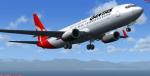
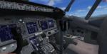
FSX Qantas B737-800 Package
(Category: FSX > Civil Jets)
54.62Mb (10242 downloads)
FSX Qantas B737-800
Updated to work in FSX by Chris Evans using the FSX default B737-800 VC and panel. Custom 737 sounds.
Qantas Boeing 737-800, Featuring 32bit Highly Detailed graphics with night light
effects,
the model includes all the usual things as a steering nose wheel, taxi and landing
lights, dynamics shine and all moving parts, including a fully animated landing gear
animation. Some special things include three opening doors, with visible interior.
Flexing wings, wing views and trim animation for the horizontal stabilizers.
Model, dynamics by: Project Opensky, Repaint By: Aziz Palas.
Posted Aug 10, 2011 06:44 by Chris Evans
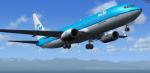
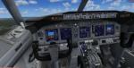
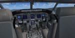
FSX KLM B737-800 Package
(Category: FSX > Civil Jets)
55.00Mb (12727 downloads)
FSX KLM B737-800
Updated to work in FSX by Chris Evans using the FSX default B737-800 VC and panel.
Custom 737 sounds.
KLM Boeing 737-800, Featuring 32bit Highly Detailed graphics with night light effects,
the model includes all the usual things as a steering nose wheel, taxi and landing
lights, dynamics shine and all moving parts, including a fully animated landing gear
animation. Some special things include three opening doors, with visible interior.
Flexing wings, wing views and trim animation for the horizontal stabilizers.
Model, dynamics by: Project Opensky, Repaint By: Aziz Palas.
Posted Aug 10, 2011 06:43 by Chris Evans
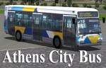
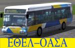
FSX/2004 Athens City Bus Package
(Category: FSX > Misc)
14.41Mb (6256 downloads)
FSX/2004 Athens City Bus Package
This is a complete freeware package of Athens City Bus #207 (Actual Line)of ETHEL-OASA (Athens Transportation System).Included 2D Panel and sound(No VC).
Original model Mitsuya Hamaguchi (hama). Repaint By Yiannis Katehis Tsetsas
Posted Aug 10, 2011 03:04 by YIANNIS KATEHIS TSETSAS
OICC, Iran V.1 Beta Version
(Category: FSX > Scenery)
0.01Mb (422 downloads)
OICC - Shahid Ashrafi Esfahani/Kermanshah Airport, Located in Kermanshah, Iran. Airport edited by the Virtual Naval Forces. The VNF uses it for some training operations, this airport is still being edited. (beta version)
Posted Aug 9, 2011 22:02 by NYVictor
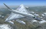
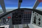
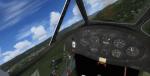
B58 Hustler Package
(Category: FSX > Military)
6.58Mb (8770 downloads)
B58 Hustler. Updated to work in FSX with new XML gauges added.
This aircraft was the first operational nuclear bomber capable of
supersonic speed, built in 1956; it won a lot of performance records
and influenced heavily the cold war.
The model was realized using FSDS2 and is my first model; it has many
animated parts, original 2d panel and a virtual cockpit
with all required gauges.
Sounds (included) are derived from the original sounds by Mike Hambly. Original author was Massimo Altieri.
The aircraft is quite old now so the VC is quite basic compared with today. But it is free!!
Updated by Danny Garnier
Posted Aug 9, 2011 12:35 by GARNIER D
Hacienda Murcielago, Guanacaste, Costa Rica
(Category: FS2004 > Scenery)
0.07Mb (175 downloads)
Aerodromo Murcielago
MRMC
Guanacaste, Costa Rica.
Airport located at Hacienda Murcielago in Guanacaste, Costa Rica
Posted Aug 9, 2011 09:27 by Alberto Thomas - Costa Rica
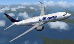
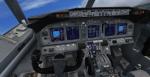
FSX Lufthansa B737-800 Package
(Category: FSX > Civil Jets)
54.66Mb (7080 downloads)
FSX Lufthansa B737-800 package. This Boeing 737-800 British Airways repaint features the most realistic shadow, shine and reflective effects. Modified for FSX using the default 737-800 VC and panel. Features custom 737-800 sounds. Aircraft.cfg edited to work in FSX. Featuring 32bit Highly Detailed graphics with night light effects, the model includes all the usual things as a steering nose wheel, taxi and landing lights, dynamics shine and all moving parts, including a fully animated landing gear animation. Some special things include three opening doors, with visible interior. Flexing wings, wing views and trim animation for the horizontal stabilizers. Model, dynamics by: Project Opensky, Repaint By: Aziz Palas. Modified for FSX by Chris Evans.
Posted Aug 9, 2011 07:51 by Chris Evans
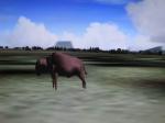
Animal World Scenery - Nth America Animal Scenery
(Category: FS2004 > Scenery)
24.08Mb (2065 downloads)
Animal World Scenery - Nth America. Contains 560 animals, reptiles, birds from the continent of North America. For use in scenery FS2004 (may work in other's but not tested). Of the many thousand gmax-things I have made through years the global animal scenery is one of my dearest. This library contains more than 3000 BGL-files. It puts singles or groups of animals into your Flight Simulator 2004 as static scenery. Marine animals and terrestrial animals. Mammals, reptiles and birds - more than a hundred species. By land by water and by air in places where they occur in reality world.
Posted Aug 9, 2011 06:37 by Ivar Danielsen