


All Files > Page 3092
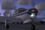
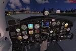
Aero Commander-Meyers 200D Package
(Category: FSX > Props)
8.16Mb (25541 downloads)
FSX SP-2 Acceleration
Aero Commander-Meyers 200D
Four seat GA aircraft, origionally made by Meyers, then production taken over by Aero Commander. Blessed with a strong airframe, speed, and smooth flying, the Meyers could have competed with any Bonanza type plane, had it better marketing and dealer support.
THis FSX model is based on a real Meyers 200D, and has two paint schemes, full ani's, and VC.
NOT tested in Vista or DX10. Tim Conrad
Posted Dec 26, 2008 03:58 by Tim Conrad
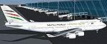
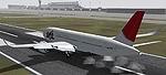
Boeing 747-400 Palestinian
(Category: FS2004 > Civil Jets)
10.25Mb (1373 downloads)
Palestinian Boeing 747-400. Model by Project Opensky. Repaint by Yvan Young
Posted Dec 26, 2008 03:32 by Paul Atreides
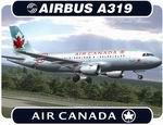
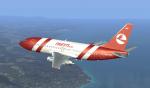
Air Canada Airbus A319
(Category: FS2004 > Civil Jets)
10.51Mb (8835 downloads)
Air Canada Airbus A319-114 - C-GBHZ. Model by Project Airbus.
Repaint by Denis Minaev
Posted Dec 26, 2008 03:23 by Denis Minaev
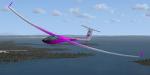
DG808S Lighthorse Textures
(Category: FSX > Gliders and Ultralites)
2.69Mb (1804 downloads)
Default DG808S Lighthorse Textures
in the theme of Falcon Von Leamy
Requires DG808S model by Microsoft. Repainted Exterior by Ken Leamy
Posted Dec 25, 2008 23:26 by Ken Leamy
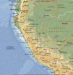
FS2004 Adventurer: Around the Peru in jet
(Category: FS2004 > Adventures)
11.23Mb (2588 downloads)
Includes flight plans to return to Peru in a twin engine jet. Includes manual in Spanish language only, in PDF format with maps of the flights, archives for FS2004 and Spanish flight plans in Route Finder format
Posted Dec 25, 2008 13:00 by Jose Munoz Escobedo
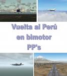

FS2004 Adventure: Around the Peru in bimotor
(Category: FS2004 > Adventures)
23.19Mb (1730 downloads)
Return to Peru in any twin engine airplace, passing 75 airports in 21 stages. Includes text (IN SPANISH ONLY) and graphical flight plans, maps and a manual in PDF format with all the instructions (in Spanish language only)
Posted Dec 25, 2008 12:47 by Jose Munoz Escobedo
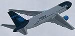
Airbus A350-800 AGS 3 services Japan Airlines
(Category: FS2004 > Civil Jets)
9.06Mb (5004 downloads)
Airbus A350-800 AGS 3 services Japan Airlines (JAL). Model by Camil Valiquette. Paint by: Yvan Ung
Posted Dec 25, 2008 07:07 by Yvan Ung
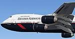
British Airways Boeing 747-236B landor
(Category: FS2004 > Civil Jets)
13.81Mb (7356 downloads)
Boeing 747-236B British Airways landor.
This aircraft is made by Project OpenSky
Model
Project-Opensky
Painted Corey Ford
Posted Dec 25, 2008 06:58 by Paul Atreides
Boeing 767-200 GEA2 Mexicana New Colors
(Category: FS2004 > Civil Jets)
7.85Mb (5844 downloads)
Boeing 767-200 GEA2 Mexicana New Colors. Model by Project Opensky.
Posted Dec 25, 2008 06:58 by Paul Atreides
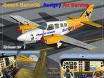
Beech Baron 58 Aurigny Air Service textures
(Category: FS2004 > Props)
1.40Mb (3528 downloads)
Aurigny Air Service textures only
for default FS2004 Beech Baron 58
repainted by Thierry PUJOL
Posted Dec 25, 2008 06:47 by Thierry PUJOL