


All Files > Page 3100
Genesis 2 for FS2004
(Category: FSX > Gliders and Ultralites)
8.13Mb (6105 downloads)
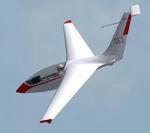
Genesis 2 for FS2004
The GENESIS 2 is a modern Standard Class racing sailplane of unusual configuration .
It is made of composite materials, with a self-stable wing, utilising the latest design and aeronautical construction technology.
This glider was made with g-Max and features full animations,detailled V/C with a pilot that can be active or hidden and custom built gauges.The model is also compatible with FSX SP2
By David Rowberry
Posted Dec 17, 2008 18:23 by David Rowberry
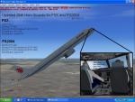
FSX/FS2004 Stall Horn Update
(Category: FS Sounds > Flight Simulator Sounds)
0.57Mb (1680 downloads)
This is the stall horn update pack for FSX and FS2004, but can be used for earlier versions. The sound pack is designed for stall warnings, but can be used for overspeed warnings by modifying the file name of any of the two *.wav files. The stall horn pack is only designed for the FSX and FS9 jetliners, but can also be used for small aircraft or other addons by again, modifying the file name of any of the two *.wav files. This sound was recorded from the Nintendo's Entertainment System's game, "Hogan's Alley," when the gang was missed by the player's fire, to make the stall horn more half realistic and half non-realistic, though no copyright infringement intended. Note for FS2004 users: The stall horn volume may be lower than expected. This is normal. Sound created by Victor Vu.
Posted Dec 17, 2008 18:11 by Victor Vu
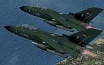
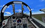
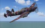
AFS Tornado, IDS, Germany, Bundeswehr, Demo Version
(Category: FSX > Payware)
3.88Mb (1384 downloads)
Demo: The Panavia Tornado is a family of twin-engine combat aircraft, which was jointly developed by the West Germany, United Kingdom and Italy. There are three primary versions of the Tornado; the Tornado IDS (Interdictor/Strike) fighter-bomber, the suppression of enemy air defences Tornado ECR (Electronic Combat/Reconnaissance) and the Tornado F.3 (only United Kingdom) a air fefence variant. It is one of the world's most sophisticated and capable interdiction and attack aircraft, with a long range, large payload and high survivability.
Posted Dec 17, 2008 11:28 by Andreas Meyer
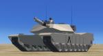
U.S. ARMY M1A1 Abrams Tank
(Category: FSX > Misc)
1.97Mb (12875 downloads)
FEATURES:
- animated wheels, turret and main gun
- animated commander pops out hatch in new ACU camo
- good offroad and hill climbing dynamics
- only a GPS window in the 2D cockpit
* This model was created for use with my new LCAC for some amphibious assault action in Multiplayer or simply as a standalone offroad vehicle.
compiled with the FSX SDK for FSX ONLY by Bruce Fitzgerald
Posted Dec 17, 2008 09:51 by Bruce Fitzgerald
FSX Enhanced Autogen World Package
(Category: FSX > Scenery)
59.60Mb (41796 downloads)
This package upgrades 522 world wide autogen building textures and changes the entire FSX world. The enhanced autogen has a much more robust and realistic look from the building surface details, the roof details including roof utilities and weather wear, and, it adds an awesome night lighting enhancement to autogen. This package does not require GEX or any other addon to use. This package can be used with FSX default or any addon which calls the default FSX autogen. The night lighting addition will add entire new level of realism to the FSX default night textures or GEX Enhanced USA/Canada and are a great match for our upcoming GEX Europe release. Please note these are only textures for auto-generated houses, buildings, offices, apartments, etc and are not the major city skyscrapers and landmarks.There is absolutely no performance loss -or- performance gain when using these textures which are ONLY for FSX and can not be used in FS9. Happy Holidays from Team GEX to the entire sim community! From Nick Needham and Anthony Vos of Ground Environment X. See update next page!
Posted Dec 17, 2008 02:58 by Nick Needham and Anthony Vos o
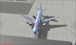
Boeing 777-300
(Category: FSX > Civil Jets)
36.78Mb (15859 downloads)
The default FS2004 Boeing 777-300 updated for FSX. Can use jetways. Cargo vehicles set in the correct Position. Also Added new camera Views to the 777-300
Posted Dec 17, 2008 02:15 by Thomas Mendoza
CL-415 Splash Screen
(Category: Videos/Splashscreens > Splashscreens)
0.56Mb (818 downloads)
2 Hellenic airplanes will be shown when you start your game. Please read the txts before installing.
Posted Dec 17, 2008 02:08 by George Moustopoulos
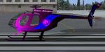
MD500E Western Helecopters Textures
(Category: FSX > Helicopters)
2.72Mb (919 downloads)
Repainted Exterior by Ken Leamy
in the theme of Western Helecopters 1983
Requires MD500E model by Peter and Tomas Nemeth
FS2004 3DS MAXGMAX MD Helicopters MD500E Package-
Required files:
required file
Posted Dec 16, 2008 18:33 by Ken Leamy
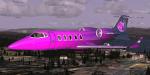
Learjet 60 Custom Edition Textures
(Category: FSX > Civil Jets)
1.54Mb (1767 downloads)
Repainted of PAD Bombardier Learjet 60 with Lighthorse colors
I hope you like them
You need FS2004 Bombardier Learjet 60 Package by Jean-Pierre Brisard, Barry Blaisdell, Bob May & Kevin Pardy - Premier Aircraft Design.
Required files:
required file
Posted Dec 16, 2008 18:12 by Ken Leamy
.png-thumb.jpg)
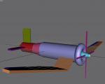
CFS3 Lewis Offspray (Unfinished Gmax project)
(Category: FS Design > Design Source Files)
1.67Mb (511 downloads)
This is a fictional aircraft for CFS3. I was in the process of making it but found I didn't have enough experiance with CAD and certainally no programming knowlege! Refer to the File_ID.diz for more imformation. included is part-finished airframe and part-finished rear-gunner.
Posted Dec 16, 2008 13:58 by John Sturt