


All Files > Page 1357
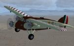
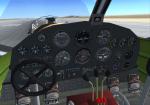
FSX Caproni CA 101 Updated
(Category: FSX > Vintage)
7.18Mb (2450 downloads)
FSX update for F. Giuli's Caproni CA 101. This aircraft was an Italian tri-motor plane
during World War II. The package features
FSX compatible gauges and a new gauge arrangement vor the VC. Model by F. Giuli,FSX configuration by Michael Pook.
Posted Dec 10, 2013 09:22 by Michael Pook
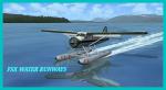
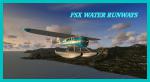
FSX Water Ways Port I.D's
(Category: FSX > Utilities)
1.22Mb (3060 downloads)
FSX Waterways I.D for Sea Planes and Float Planes. This will Help you find Waterway Airports to take-off or land at much easier, Identify them and locate them much easier. in PDF Format. Print it off and keep at Hand for close reference.
Jetranger
Posted Dec 9, 2013 19:51 by Jetranger

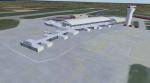
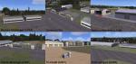
Jersey Ultimate Edition
(Category: FS2004 > Scenery)
27.38Mb (682 downloads)
Jersey Airport is located on the small island of Jersey in the English channel. It has a single runway that is just shy of 2000 meters in length. This is a concept version of the airfield, consisting of a redesigned terminal and unique qualities.
Posted Dec 8, 2013 20:29 by Mark Piccolo - Soarfly Concepts
9.jpg-thumb.jpg)
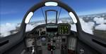
Iris Mig29 Fulcrum Megapack
(Category: FSX > Military)
105.76Mb (28227 downloads)
Iris Mig 29 megapack with many models, textures and effects. Liveries include Russia, Malaysia, Czech, Iran, Iraq, India, Cuba, old East Germany, Luftwaffe, Soviet, Romania, Hungary, Bangladesh, Algeria. High quality package also includes a great VC.
Posted Dec 8, 2013 14:53 by Alex Guerreiro
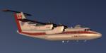
FSX DeHavilland Dash 7 Ice Recon Package
(Category: FSX > Props)
61.63Mb (12571 downloads)
FSX DeHavilland Dash 7 Canadian Ice Recon (Port Over-Not Native)
by Milton Shupe, Scott Thomas, Mike Kelly, Bernt Stolle, Tom Falley, and sounds by Nigel Richards.
Pkg incl one model, custom panel and gauges, custom sounds, two Flight Model options, and the CIR livery.
Dash 7 IR (ice reconnaissance) entered service with the Department of Environment (Canada) in 1986. This aircraft is a modified example of the Dash 7 Series 150, modified for use in surveying sea ice and icebergs in the shipping and oil drilling regions of the Labrador coast and the Gulf of St Lawrence.
*Will Not Work in FS9 (FS9 version available) Also includes full interior.
Posted Dec 8, 2013 10:32 by Milton Shupe


FS2004 DeHavilland Dash 7 Ice Recon Package
(Category: FS2004 > Props)
61.42Mb (5066 downloads)
FS2004 DeHavilland Dash 7 Canadian Ice Recon
by Milton Shupe, Scott Thomas, Mike Kelly, Bernt Stolle, Tom Falley, and sounds by Nigel Richards.
Pkg incl one model, custom panel and gauges, custom sounds, two Flight Model options, and the CIR livery.
Dash 7 IR (ice reconnaissance) entered service with the Department of Environment (Canada) in 1986. This aircraft is a modified example of the Dash 7 Series 150, modified for use in surveying sea ice and icebergs in the shipping and oil drilling regions of the Labrador coast and the Gulf of St Lawrence.
Not for FSX-There is a separate FSX Port Over Package
Posted Dec 8, 2013 10:19 by Milton Shupe
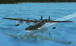
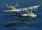
FSX Kawanishi Mavis Flying Boat with added features
(Category: FSX > Vintage)
2.87Mb (1250 downloads)
FSX WWII flying Boat Kawanishi Mavis from Alphasim with special features. The panel is now FSX-compatible configured. Five cameras shows interesting views of the gunner positions and four external cameras show the best sides of the airplane. Six of eight AA-guns are configured with weapon effects. Panel reconfiguration by Michael Pook, camera- and weapon configuration by Erwin Welker
Posted Dec 8, 2013 09:19 by Erwin Welker
Version 2.0 of Five FSX Terrains Around Dijon, France, Improved or New
(Category: FSX > Scenery)
0.29Mb (982 downloads)
Version 2.0 of our Five FSX Terrains Around Dijon, France, Improved or New. Beaune, Darois, Nuits-Saint-Georges, Pouilly, Til-Chatel, Dijon-Longvic. Freeware. That version 2.0 brings varied improvements wich improve our terrains around Dijon, France in terms of scenery, runway markings, for example, or in terms of AI traffic (and too a bonus about AI traffic). Comes with a French readme too. By G. Guichard
Posted Dec 8, 2013 07:44 by Guichard G.
Fix-V2 For Dornier Do-24K Flying Boat
(Category: FSX > Vintage)
0.45Mb (1028 downloads)
FSX/Acceleration fix with improved flight dynamics for Dornier Do24K flying boat (DO24VC-FSX.ZIP). Now the seaplane allows easier take offs and higher speed. The 2D-panel now shows the gun turret permanently in front of the cockpit. Before, a strange effect showed the virtual gun turret in front of the 2D-panel while on water and disapeared when airborne. By Erwin Welker.
Required files:
required file
Posted Dec 8, 2013 06:20 by Erwin Welker
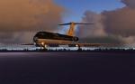
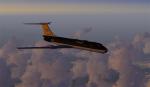
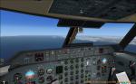
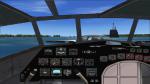
Tupolev Tu-134A Super Performer
(Category: FSX > Civil Jets)
29.52Mb (3053 downloads)
VikingAir`s Tupolev Tu-134A SuperPerformer.
Enjoy this classic jetliner. Hear the powerfull sound of the Soloviev D-30-II turbofans. Smoke file included.
Aircraft.cfg tuned up a little. 2d Cockpit.
Enjoy your flight
Posted Dec 8, 2013 04:31 by Kim Schandorff