


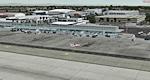
77.23Mb (2432 downloads)
Detailed scenery of Long Beach Airport, Long Beach, California, USA. This is version 5 incorporating the latest design techniques and upgraded to the latest development stage. This version includes the modern new terminal and the new parking garage. This is a brand new stand alone version for FSX/P3Dv2. **Includes all fixes**
Posted Sep 2, 2014 13:45 by Shehryar Ansari
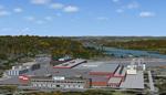
1.57Mb (598 downloads)
FSX Sikorsky Aircraft Company, Stratford, CT
Airport, helipads, aprons, and buildings of
the main Sikorsky Aircraft complex off the
Merritt Parkway in southern CT. Includes the
whirl stands and drop tower at the north side
of the property. RWY12 download required for
cars and street lamps. Source data primarily
Google Earth along with some ground level
photos. By David Allan.
Posted Sep 2, 2014 12:55 by uploader
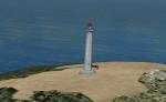
0.07Mb (723 downloads)
Adds lighthouses to the Oregon coast. Includes:
Cape blanco (near Brandon state Airport),
Cape Arago (near Brandon State Airport),
Heceta Head (near Florence Municipal Airport),
Yaquina Head (near Newport Municipal Airport),
Cape Meares (near Tillamook Airport)
Haystack Rock (near Seaside municipal). Directions included.
Posted Sep 1, 2014 02:27 by D. Chris

0.45Mb (2345 downloads)
This is a fix for my scenery Airport Dortmund edlw.zip.
Many useres told me that fsx doesn't show the carpark building in front of gate 0 while cars are parking up in the air or there is only a black image. The reason for this is a missing third-part library in the addon scenery of many users. To solve this problem I built a library containing a carpark building on my own.
Users who do not have this problem don't need to install this fix.
Required files:
required file
Posted Aug 29, 2014 04:55 by Klaus-Peter Kniffka
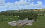
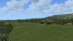
35.15Mb (353 downloads)
Skelling Farm home of Eden Soaring Club X5SF, Skirwith, Penrith, Cumbria. Home to strong rotor known locally as "the Helm". This scenery is reccomended to work with ORBX England, Having ORBX Global Vector will enhance the scenery but it is not required.
Posted Aug 26, 2014 00:28 by Jon Davidson
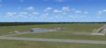
17.61Mb (473 downloads)
Earlton (CYXR) For FSX. Earlton is a relatively small airport serving the communities around Temiskaming Shores, in Northern Ontario, Canada, 150 km north of North Bay (CYYB). Earlton has a proper paved runway that can accomodate private jets, has a huge hangar not being utilized at this time, and a great manager. I have included two aircraft and traffic files to make them fly. You can install the planes in the SimObjects\Airplanes folder if you want. AI Pilatus PC12 by Dave Pearce. The package is self contained, standard installation using the Scenery Library buttons. Created by Fern Marques.
Posted Aug 25, 2014 13:02 by Fern Marques
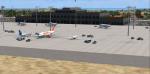
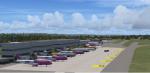
9.43Mb (2966 downloads)
Malta International Airport (IATA: MLA, ICAO: LMML) is the only airport in Malta and it serves the whole Maltese Archipelago. It is located between Luqa and Gudja and occupies the location of the former RAF Luqa. It was completely re-furbished, becoming fully operational on 25 March 1992. It is still referred to by locals as Luqa Airport, and sometimes as Valletta Airport internationally, as it is located 5 km (3.1 mi) southeast of the Maltese capital Valletta.
The airport serves as the main hub for Air Malta and a base for Ryanair. It is also home to the Area Control Center and hosts the annual Malta Airshow, visited by military and civil aircraft from various European and other countries. The airport is operated by Malta International Airport plc.
In the update I added a new fotorealistic terminalbuilding, roads and traffic.
Posted Aug 23, 2014 14:09 by Klaus-Peter Kniffka
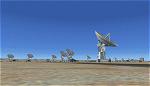
3.35Mb (1026 downloads)
The VLA or "Jansky Array", managed by the National Radio Astronomy Observatory (NRAO) consists of 27 independent radio telescope dishes, each with a diameter of 82 feet and weight of over 200 tons. Each antenna is found along the three arms of a track shaped in a Y configuration measuring 13 miles long. Using the rail tracks that follow each of these arms the antennas can be physically relocated to a number of prepared positions. At one point, the arms intersect with U.S. Route 60 which passes right through the middle of the array. It has been featured in numerous films, such as Armageddon, Independence Day, Terminator Salvation, a Bon Jovi music video, and was featured most prominently -and correctly- in the Carl Sagan novel Contact, as well as the film of the same name. Also updated is the closest airport to the VLA - Magdalena, NM - N29. It's a small dirt strip a few miles to the east, between Socorro and the VLA. It serves as a nice staging area for flights to the VLA. Includes a helipad startup location with NM99 ident. Scenery by Jason L. Terry.
Posted Aug 23, 2014 01:04 by Jason L. Terry
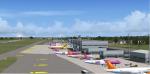
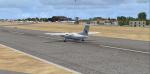
8.00Mb (3603 downloads)
Dortmund Airport (EDLW), is a minor international airport located 10 km (6.2 mi) east of Dortmund, North Rhine-Westphalia, Germany. It is mainly used for low-cost and charter flights and served approximately 2.3 million passengers in 2008. Dortmund Airport serves the eastern Rhine-Ruhr area, the largest urban agglomeration in Germany. The nearest major international airport is Dusseldorf Airport approx. 70 km (43 mi) to the southwest. Klaus-Peter Kniffka
Posted Aug 22, 2014 15:57 by Klaus-Peter Kniffka
46.17Mb (1810 downloads)
FSX scenery LFJL Metz-Nancy-Lorraine (France).
Complete rework of my former scenery for
FS2002.
Photorealistic ground texture with seasonnal
and night variations, static plane, cars,
animated flags, AGS vehicles, peoples,
birds, etc.
VAC chart included.
Works with FSX and FSXA. By D. Bur
Posted Aug 21, 2014 08:32 by uploader