


15.44Mb (11770 downloads)
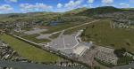
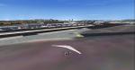
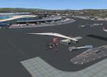
This is a scenery of Florence (Peretola) LIRQ airport for FSX. The scenery includes the photoreal area of the airport and surroundings area with a realistics autogen. The airport has been created faithfully and it has a correct position of the terminal with parking, hangars, static airplane, airport vehicles, trees and lights.
Posted Aug 6, 2014 10:55 by Matteo Veneziani
0.30Mb (541 downloads)
That freeware scenery for FSX represents the small, Tournus-Cuisery airfield (LFFX) in Burgundy, France, which is located between Chalon and Macon. Comes with a French readme too
Posted Aug 6, 2014 06:54 by G. Guichard
66.85Mb (933 downloads)
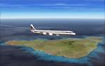
Photoscenery for Easter Island, for fsx.
This is a much reworked photo of Easter Island compiled with FSEarthTiles. Actually
it is a mix of two different files to remove maximum of clouds, before palette
adjustments.
Posted Aug 3, 2014 03:20 by Jean-Marie Guieau
1.57Mb (362 downloads)
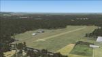
Avio Club Rieti (airfield)
Aeroclub Rieti airfield in central Italy.
For this small airport has attempted to
play area with the highest possible realism
but, to make the scenery and lighter fluid for FSX
elements were used only by default, however the Epron
corresponds to reality as well as several car parks, residential area and
tower location etc etc..
Posted Aug 2, 2014 12:28 by Voyager
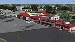
84.71Mb (2106 downloads)
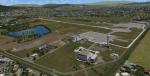
FSX/Prepar3D Scenery - Ciudad Bolivar (SVCB) - Venezuela
The National 'Tomas de Heres' Airport, located in the city of Ciudad Bolivar,
to the south of Venezuela, near the Orinoco River. is one of the airports with
more domestic and tourist traffic, due to his geographical position
Photo-terrain area improved with Autogen files.
Only compatible with versions to FSX, P3Dv1.x or P3Dv2.x.
Also includes a friendly Auto-Install.
By David Maldonado
Posted Jul 28, 2014 03:50 by David Maldonado
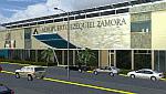
61.28Mb (1452 downloads)
The National Airport "Ezequiel Zamora" is an airport located in the
city of San Carlos, being the most important of the Cojedes State
Recently remodeled which includes the adequacy of the runway for
aircraft such as the McDonnell Douglas DC-9, Boeing 737, Airbus A319.
Photo-terrain area improved with Autogen files.
Only compatible with versions to FSX, P3Dv1.x or P3Dv2.x.
Also includes a friendly Auto-Install.
Posted Jul 27, 2014 07:06 by David Maldonado
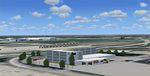
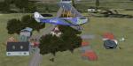
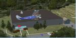
15.49Mb (1180 downloads)
Wichita, Kansas Scenery. This version adds several General Aviation hangars, the UPS Freight Hangar, as well as the Doubletree Hotel. It works and looks best with the Megascenery Kansas package. By Mike Epright
Posted Jul 26, 2014 05:49 by uploader
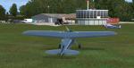
9.79Mb (468 downloads)
The airport named Taylor field (on 1970's sectional charts) is a small 1800' strip not shown in the stock FSX list of airports. There is no ICAO code or other designator I could find with extensive research. I used my own code of NY3C.
This is a part reality part historic scenery as it represents the modern day airport, the Glenn Curtiss Museum, and adjacent to the Airport a facsimile of the original horse racetrack that was used by Glenn Curtiss to fly his June Bug on July 4th 1908. It is a close As I can determine to the original spot using archival photos and conversations with the Director of the Curtiss Museum, Traff Doherty. Extensive use of new land class is also employed to give a better representation of the geographic area.
This will work with FSX stock scenery, but is designed with UTX (Flight One Software) in mind. It will work with ORBX Global and Global Vector as well. With these latter two there may be some missing roads but it won't affect the scenery.
Posted Jul 24, 2014 01:39 by Jon Davidson
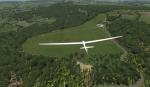
38.16Mb (773 downloads)
Can also be used with default scenery with limitations. This is a departure for me, away from the Appalachians over the pond to Merry England.
Sutton Bank, also known as Roulston Scar, is a hill in the Hambleton District of North Yorkshire in England. It is a high point on the Hambleton Hills and the North York Moors National Park with extensive views over the Vale of York and the Vale of Mowbray. It is also home to the Yorkshire Glider Club on top of the hill.
This will be the first of a small series of UK glider fields and WW2 airfields. This is specifically designed to work with ORBX England. It will show nicely on FSX stock scenery BUT the field will be not flat, but very hilly.Also works with ORBX global same caveat. ORBX Global Vector will improve the roads and vector data as will UTX Europe.
Posted Jul 24, 2014 00:57 by Jon Davidson
41.69Mb (2840 downloads)
Chhatrapati Shivaji international airport (Mumbai India) has been renovated with the addition of a new terminal and new ATC. This is not a complete version of VABB but unfinished WIP. Still, its fun to fly this scenery.
Posted Jul 20, 2014 12:48 by Ratan Lewis