


0.00Mb (992 downloads)
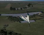
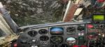
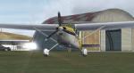
RAF Halton airfield. Situated just south of Aylesbury in Buckinghamshire, Halton airfield is home to RAFGSA Chilterns Gliding club, Halton AeroClub (HAC) and Halton Microlight Club (HMC). Brought to FSX by the new Virtual Flying Club. Future updates and more available from www.virtualflyingclub.co.uk
Posted May 19, 2010 19:15 by Jon Davidson
0.00Mb (820 downloads)
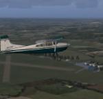
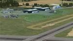
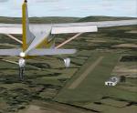
Husbos For FSX. Husbands Bosworth is located between Leicester and Northampton in the UK and is home to the UK gliding centre. Created by Virtual Flying Club team.
future updates and more available at www.virtualflyingclub.co.uk
Posted May 18, 2010 17:41 by Jon Davidson
33.83Mb (1962 downloads)
FSX Alfs UK Airfields Volume 18. Upgrades many small UK airfields whose default versions have little or no detail. Based on Google Earth and airport guides. This volume includes Baxterley X3BX, Fowlmere EGMA, Wolverhampton/Halfpenny Green EGBO. By Alf Denham
Posted May 18, 2010 06:28 by Alf Denham
11.64Mb (1051 downloads)
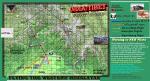
Scenery and Flights: Arunachal Pradesh is a federated state of India, located in the far northeast. It borders the states of Assam and Nagaland to the south and southeast, and shares borders with Burma/Myanmar in the east, Bhutan in the northwest, and Tibet (part of China) in the north. Arunachal Pradesh means 'land of the dawn lit mountains' in Sanskrit. You have answered Numa Airlines ad looking for experienced pilots and got the job!!. Now after a week of studying the mountain charts and the location of the airfields and towns you have been called to take tomorrow's flight. Includes New Airfields, AFCADS, Land Class, Various airport objects, Flights and lots of adventure flying. You must be able to 'read' Maps, many airfields have not been registered in the aeronautical controls!!!Suggest you have experience in STOL aircraft. Use your bright purple socks for luck!!!
Posted May 17, 2010 12:28 by Gera Godoy Canova
92.87Mb (2611 downloads)
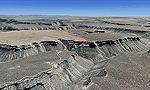
FS2004/FSX Mesa Verde National Park, Cortez (KCEZ), Colorado (CO) photo scenery. Mesa Verde National Park is famed for its numerous ruins of cliff dwellings built in the 12th century by ancient Pueblo people called Anasazi. Cliff dwellings are highly defensible stone villages situated under aloves (rock overhangs) along the canyon walls. The largest cliff dwelling in the park is Cliff Palace, which is the largest cliff dwelling in North America. Cliff Palace contained 150 rooms and housed approximately 100 people. Unfortunately you won't see the cliff dwellings from the air, because they are under the cliffs but you will see everything else like all roads, trails and facilities. By Gottfried Razek.
Posted May 17, 2010 06:23 by Gottfried Razek
0.00Mb (734 downloads)
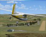
Easterton airfield for FSX. Situated just south of the town of Elgin in Scotland, Easterton is home to both the RAF Fulmar and civilian Highland gliding clubs who share the use of facilities and aircraft. Updates for this scenery and more can be found at virtualflyingclub.co.uk
Posted May 16, 2010 17:15 by Jon Davidson
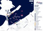
0.59Mb (785 downloads)
This is the track Red Bull Air Race Abu Dhabi 2010 Release without the scenery of the Corniche of Abu Dahbi with new pylons for default scenery FSX
Posted May 16, 2010 14:28 by Sy Dsg Siscot Yves

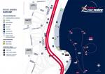
0.43Mb (1123 downloads)
This is the track Red Bull Air Race Windsor-Ontario 2010,this scenery work with default scenery FSX
Posted May 16, 2010 08:13 by Sy Dsg Siscot Yves
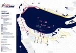
0.53Mb (1337 downloads)
This is the track Red Bull Air Race Rio De Janeiro 2010,this scenery work with default scenery FSX
Posted May 16, 2010 08:11 by Sy Dsg Siscot Yves
0.55Mb (851 downloads)
This is the track Red Bull Air Race Perth 2010 on the Sawn Bay central of the city of Perth Australia work with default scenery FSX
Posted May 16, 2010 08:08 by Sy Dsg Siscot Yves