


1.07Mb (1363 downloads)
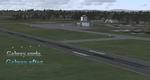
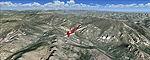
Galway airport on the west coast of Ireland. New taxiways, parking and buildings.
Mathieu O'HARE.
Posted Feb 15, 2010 17:35 by Mathieu O'HARE
1.17Mb (1600 downloads)
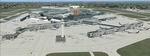
Lleida-Alguaire Regional Airport (LEDA)located in Alguaire, 15 km (9.3 mi) from the centre of Lleida, Catalonia, Spain. A new airport in real life and now in FSX as well. The airport opening ceremony took place on January 17, 2010 with the first flight on February 5. See installation file enclosed for more information -- www.aeroportlleida.cat
Version 1.1 includes updated AFCAD with some WOAI based Traffic Files.
Posted Feb 15, 2010 12:58 by Kambiz Agazi
0.99Mb (2841 downloads)
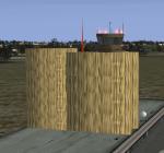
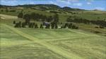
Buochs LSZC Switzerland. Located in Luzern, Switzerland.
Posted Feb 15, 2010 04:09 by Miles H
94.68Mb (2475 downloads)
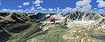
FS2004/FSX Leadville (KLXV), Mt. Elbert, Colorado (CO) photo-scenery Package.
This scenery brings you another 3500 sq km of beautiful Colorado in 4.7m/pix
quality. It extends the Aspen scenery to the east and contains more gorgeous
Continental Divide area of the Rocky Mountains. Covers Leadville Lake County
Airport (KLXV), which is the highest airport in North America (9927 feet) and Mt.
Elbert, which is the highest peack in the Rocky Mountains (14,443 feet). By
Gottfried Razek.
Posted Feb 14, 2010 13:14 by Gottfried Razek
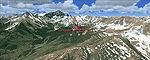
92.50Mb (3181 downloads)
FS2004/FSX Aspen (KASE), Colorado (CO) photo scenery Package. This scenery brings
you another 3500 sq km of beautiful Colorado in 4.7 m/pix quality. By Gottfried
Razek.
Posted Feb 14, 2010 12:59 by Gottfried Razek
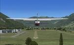
1.13Mb (3363 downloads)
FSX Swiss Airports Volume 1. Add-on scenery for Locarno, Switzerland, and area Icao included in readme. By Miles Hanna
Posted Feb 14, 2010 12:01 by Miles Hanna
96.91Mb (1985 downloads)
FS2004/FSX Park County Colorado photo scenery (CO). Covers the gap between the Leadville and Colorado Springs North sceneries and provides you with continuous coverage for longer cross country flights. By Gottfried Razek.
Posted Feb 12, 2010 07:02 by Gottfried Razek
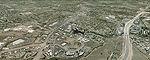
89.49Mb (3132 downloads)
FS2004/FSX Colorado Springs North photo-scenery (CO). This region covers the area between Denver and Colorado Springs. It extends the Denver scenery to the south. Just north of Colorado Springs you can see the widespread United States Air Force Academy which, with its many buildings, covers a huge area of 18,000 acres. The Academy Airfield (KAFF) which lays in the northeastern corner of the area is used for training cadets in airmanship courses, including parachute training, soaring and powered flight. By Gottfried Razek.
Posted Feb 12, 2010 06:58 by Gottfried Razek
0.65Mb (16549 downloads)
EGLL, London Heathrow AFCAD. Version 2 includes two options for the user EGLL represents a modification to the default FSX scenery per February 2009 specifications. Among the many changes is the inclusion of the new Terminal (5a, 5b and 5c) with new taxiways and taxiway signs; the extension of Pier 5 at T3; the new control tower with tower view; new ILS approaches with transitions for all runways plus new RNAV approach to 27L; airline terminal assignments per fall 2009 specifications; new taxiway designations and signage plus much more. By Kambiz Agazi.
Posted Feb 12, 2010 03:55 by Kambiz Agazi
11.02Mb (1651 downloads)
Tasmanian bush Strips models 5 of Southern Tasmania's bush strips with more to come. Each airstrip is created with satellite imagery, Afcads and some custom scenery. The airstrips included are: Bruny Island, Campania, Nugent, Bathurst Harbour and Swansea. For Bush flyers who enjoy Tasmania's mountainous regions this package is sure to satisfy. For FSX only.
Posted Feb 10, 2010 20:53 by Matthew Devenish