


-1945.png.jpg-thumb.jpg)
-1945.png.jpg-thumb.jpg)
2.29Mb (286 downloads)
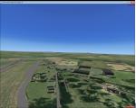
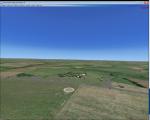
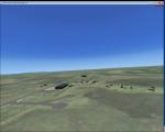
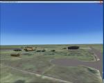
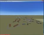
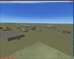
RAF Honeybourne was a Royal Air Force station located 0.6 miles (0.97 km) south of Honeybourne, Worcestershire, England and 4.6 miles (7.4 km) east of Evesham, Worcestershire, England.
The airfield was home to No. 24 Operational Training Unit RAF (OTU) which used Vickers Wellingtons and Armstrong Whitworth Whitleys from 15 March 1942 until July 1945 flying many operational bombing and leaflet dropping operations.
A number of units from Ferry Command were based here including a ferry training unit using Lockheed Hudsons and Bristol Beauforts.
The airfield was also temporarily home to No. 21 OTU flying Wellingtons from RAF Enstone from August 1945 for two months because the runways at their home base were being repaired. From October 1945 until 1946 107 Sub Storage Unit from No. 8 Maintenance Unit used the airfield for storing Wellingtons and General Aircraft Hamilcar gliders.
The role of the airfield after the war changed with the reduction of flying movements and with a slight change in what the units did on the airfield when No. 107 Sub Storage Unit from 1947 began to collect no longer needed Wellingtons which were then scrapped and taken to Weston Subedge goods yard (which was near to the south-western corner) where the railway would take them to the necessary destination.
In July 1948 the site was closed and much has reverted to farmland with runways being removed in 1968. Since then, the airside area has evolved into the Honeybourne Airfield Trading Estate with the five hangars being used for different purposes
Posted Jun 2, 2016 10:02 by Terry Boissel
10.06Mb (896 downloads)
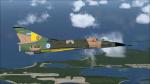
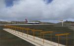
Falklands 2007 for Flight Simulator X.
This scenery has been released to remember the war of the Falkland Islands/Malvinas in 1982.
The scenery replaces the default mesh, landclass, coastlines and models with completely new and 'hand built' components.
Posted May 31, 2016 00:24 by Ronald Falzon
1.58Mb (794 downloads)
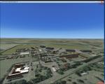
RAF Bassingbourn is a former Royal Air Force station located in Cambridgeshire approximately 3 mi (5 km) north of Royston, Hertfordshire and 11 mi (18 km) south west of Cambridge, Cambridgeshire, England.
RAF Bassingbourn was constructed by John Laing & Son between 1937 and 1939 in the parishes of Wendy and Bassingbourn immediately to the west of the A14 (now the A1198) road. The site selected was low ground between several tributaries of the River Cam. The area had been long cleared of forest and tended to be swampy and unstable, and because the boggy ground produced a persistent mist over the large meadow the site was considered ideal for airfield camouflage.
During the Second World War it served first as an RAF station and then as a bomber airfield of the Eighth Air Force, of the United States Army Air Forces (USAAF). It remains the home of the Tower Museum Bassingbourn. From 19 August 1942 to 25 June 1945, Bassingbourn served as headquarters for the 1st Combat Bombardment Wing of the 1st Bomb Division. It was assigned USAAF designation Station 121.
The RAF resumed occupation of Bassingbourn on 26 June 1945, the airfield was officially returned on 10 July 1945. The station became one of the main airfields for long-range transport aircraft. In 1948 and 1949 Avro York, Avro Lancaster and Douglas Dakota aircraft from the base took part in the Berlin Airlift, a massive operation transporting essential commodities to the beleaguered city.
In February 1952, RAF Bassingbourn received its first allocation of English Electric Canberra bombers and became the first jet bomber operational conversion unit (OCU) in the world. Canberras operated from Bassingbourn for 17 years and one of the aircraft is on static display in the Barracks. From 1963 to 1969 the Joint School of Photographic Interpretation was also located there.
On 29 August 1969, the last RAF Commanding Officer, Sqn Ldr A.M. McGregor MBE, turned over the station to the British Army as Bassingbourn Barracks.
The barracks were established, on the site of the former RAF Bassingbourn airfield, in January 1970, as the new Depot for the Queen's Division. The depot was responsible for training recruits undergoing their 19-week basic training before joining a regular battalion; in 1993 the Barracks were re-designated the home of the "Army Training Regiment, Bassingbourn" and remained as such for nearly 20 years. Bassingbourn Barracks closed as an army training location in August 2012.
The site was reopened for training Libyan soldiers in 2014 but closed down the same year.
Since approximately 1970 the site has retained its RAF links by being the home of 2484 (Bassingbourn) Squadron Air Training Corps.
Posted May 29, 2016 12:15 by Terry Boissel

0.75Mb (317 downloads)
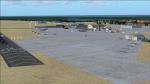
Sharae Faisal Air Base is the Pakistan AirForce Southern Air Command base and the PAF Air War College. The default OPSF has been modified according to Google maps. I added some extra features just for enjoyment like a small naval mess with huts and a naval fleet in the Arabian sea. Enjoy!
Posted May 25, 2016 10:52 by uploader
1.50Mb (247 downloads)
Initially intended as a satellite station for RAF High Ercall; RAF Wheaton Aston (ICAO X3WA) opened for business on 10 February 1942 when the station was taken over by Flying Training Command and was used by No11 Pilots Advanced Flying Unit (PAFU) at RAF Shawbury as a relief landing ground (RLG).
The Station was used intensely by the Airspeed Oxford and when No 21 PAFU with a large formation of Oxfords some 150 airframes being on charge formed at the station in 1943 the unit had its own (RLGs)
When the PAFU moved to Morton in the Marsh its departure marked the end of RAF Wheaton Aston and the station closed in 1947, and like many war time stations reverted back to farmland.
Posted May 24, 2016 11:05 by Terry Boissel
9.21Mb (1194 downloads)
Drzewiecki Design Grass is a freeware, fully automated package of ultra high quality, 4096x4096 pix grass and snow textures for Microsoft Flight Simulator 2004, Microsoft Flight Simulator X, FSX:SE and Lockheed Martin Prepar3D (all currently available versions). It will enhance ground textures in the whole FS.
Microsoft Flight Simulator X and Lockheed Martin Prepar3D have texture resolution limit, which is 1024x1024 pixels. It is possible to select higher resolution by manually editing configuration files but Drzewiecki Design Grass will do that for you automatically!
Default FS9's grass is 128x128pix and with Drzewiecki Design Grass you can admire the 1024x1024 ground texture resolution.
Extra features: Drzewiecki Design Grass will automatically add a HIGHMEMFIX=1 tweak to your FS, which will prevent texture disappearing from aircraft and buildings + snow texture for winter flying.
Enjoy your virtual flying with Drzewiecki Design!
Posted May 24, 2016 08:15 by Drzewiecki Design
1.06Mb (225 downloads)
Opened on Saturday 8 August 1942, it was used by both the Royal Air Force and then later United States Army Air Forces.
During the war it was used as a bomber and fighter airfield. After the war, it was used for experimental work before it was closed in 1959.
Posted May 22, 2016 12:06 by Terry Boissel
0.26Mb (966 downloads)
These files update the "FSX_St_Helena_Ascension_Tristan-da-Cunha.zip" project to its current, real-world status. They update the St. Helena (FHSH) localizer from the previous 15-degree offset to the present 5-degree offset, remove the glideslope from the ILS, and update the naming of the approach plates.
"FSX_St_Helena_Ascension_Tristan-da-Cunha.zip" is required.
Required files:
required file
Posted May 21, 2016 16:40 by Carlyle Sharpe

14.32Mb (1111 downloads)
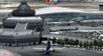
Baku X DEMO is the scenery featuring a highly detailed representation of UBBB Heydar Aliyev airport in Azerbaijan. This product is fully compatible with FSX and FSX:SE.
It's a fully functional DEMO version of the commercial payware product. It features same airport layout as in the full version but with limited 3D objects and low resolution textures. Using this free demo ensures no problems with online (VATSIM, IVAO, multiplayer etc.) flying in case some users use the payware scenery and some don't.
Heydar Aliyev International Airport (IATA: GYD, ICAO: UBBB) (former Bina International Airport) is the main international airport in Azerbaijan, the home of Azerbaijan Airlines, the national flag carrier.
It's equipped with an automatic installer, which means that the scenery will be automatically added to the Flight Simulator Scenery Library.
Please uninstall all previous versions of this airport you may have installed before. Please make also sure that no duplicated AFCAD files are installed!
Enjoy your virtual flying with Drzewiecki Design!
Posted May 21, 2016 15:19 by Drzewiecki Design
1.27Mb (257 downloads)
RAF Upper Heyford was a Royal Air Force station located 5 miles (8 km) north-west of Bicester near the village of Upper Heyford, Oxfordshire, England.
The station was first used by the Royal Flying Corps in 1916 but was not brought into use for flying until July 1918 by the Royal Air Force. During the inter-war years and continuing through the Second World War until 1950 Upper Heyford was used mainly as a training facility. During the Cold War, Upper Heyford initially served as a base for United States Air Force Strategic Air Command (SAC) strategic bombers and later United States Air Forces In Europe (USAFE) tactical reconnaissance, fighter and fighter-bomber aircraft in the UK.
Posted May 21, 2016 09:49 by Terry Boissel