


1.36Mb (251 downloads)
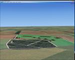
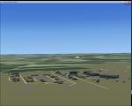
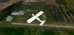
RAF Saltby (ICAO X3SY)was a World War II airfield in Leicestershire, England. The airfield is located approximately 8 miles (13 km) northeast of Melton Mowbray; about 90 miles (140 km) north-northwestof London.
It was opened in 1942, and was used by both the Royal Air Force and United States Army Air Forces. During the war it was used primarily as a transport airfield. Like many airfields of the time it closed after the war in 1945 but kept in reserve until 1955.
Today the remains of the airfield are located on private property and, now known as Saltby Airfield, is used primarily for gliding.
Source: Wikipedia
Posted Apr 27, 2016 09:18 by Terry Boissel
37.56Mb (467 downloads)
New version for the airfield of Montagnana in northern Italy with the corrected photorealistic base and more objects, included the city of Montagnana.
Thanks to Pasquale Marrulli for the collaboration!
Posted Apr 26, 2016 13:11 by Carlo Boninsegna
0.63Mb (214 downloads)
RAF Harwell is a former Royal Air Force station in former Berkshire, near the village of Harwell, located 4.8 miles (7.7 km) south east of Wantage, Oxfordshire and 17 miles (27 km) north west of Reading. The bulk of the Station lay within Chilton parish; about a third was in East Hendred; and the smallest portion was in Harwell. The first Commanding Officer, upon being asked what the name of the new airfield should be, responded that it should be named after the parish in which his house lay and this happened to be Harwell.
Posted Apr 26, 2016 08:35 by Terry Boissel
0.02Mb (284 downloads)
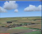
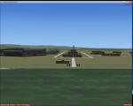
RAF Keevil (ICAO X2KV) is a former Royal Air Force station located 4 miles (6.4 km) east of Trowbridge, Wiltshire, England.
The airfield was built on a site previously ear-marked for the purpose in the mid-1930s. Consisting of 3 long concrete runways the airfield was used by the Royal Air Force and the United States Eighth and Ninth Air Forces.
In March 1944, No's 196 and 299 Squadron Short Stirling glider tugs of No. 38 Group RAF arrived followed by a large number of Horsa gliders, crewed by Army pilots of the Glider Pilot Regiment.
The RAF Stirling aircraft were crewed by RAF, RCAF, RAAF, RNZAF and SAAF personnel and were engaged in SOE and SAS drops. largely in France, and in glider towing.
Their involvement in the Normandy invasion of France and Operation Market-Garden is well remembered by Keevil and Steeple Ashton villagers. Casualties of army and air force personnel were heavy and a number of aircraft were lost.
Posted Apr 24, 2016 13:57 by T K Boissel
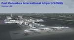
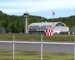
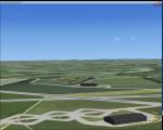
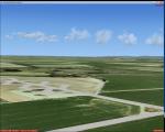
149.00Mb (1382 downloads)
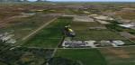
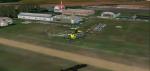
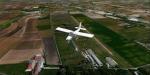
FSX Port Columbus International Airport (KCMH)
Port Columbus International Airport is located 6 miles
east of downtown Columbus, Ohio, USA. KCMH is the largest
passenger airport in central Ohio and second busiest in the
state after Cleveland Hopkins International Airport. Modeled
in version 1.00 is an updated AFCAD airport layout,
custom-made terminal building, and surrounding facilities.
By Matthew Derr.
Posted Apr 24, 2016 09:43 by uploader
2.56Mb (821 downloads)
Small airport in Slovenia, close to Croatia. Just copy content of LJCE folder into your Addon Scenery folder in FSX or P3D. It uses standard FSX object libraries. It looks best with ORBX FTX Global, as you can see on screeenshots.
Posted Apr 23, 2016 08:50 by Zeli
1.18Mb (293 downloads)
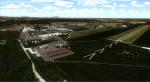
RAF Tarrant Rushton was a Royal Air Force station near the village of Tarrant Rushton east of Blandford Forum in Dorset, England from 1943 to 1947. It was used for glider operations during World War II and later revived for civilian operations. It is currently disused, though some buildings survive.
Horsa gliders from Tarrant Rushton left for France on the eve of D-Day, to begin Operation Tonga with an action that would later become known as Pegasus Bridge. Among the glider pilots was Jim Wallwork, on a Horsa nicknamed Lady Irene. The Tarrant Rushton gliders landed in occupied France shortly after midnight. Wallwork's aircraft was the first to touch down, but it landed heavily: the force of the impact catapulted both Wallwork and his co-pilot John Ainsworth through the front of the cockpit. Although stunned, this made them the first Allied troops to touch French soil on D-Day.
Other gliders were later flown from the airfield to Arnhem to take part in Operation Market Garden. During the closing stages of WWII, aircraft were used for SOE operations.
Posted Apr 22, 2016 10:45 by Terry Boissel
29.77Mb (317 downloads)
Scenery for the airfield of Montagnana (LI40) in the north of Italy.
Posted Apr 21, 2016 12:47 by Carlo Boninsegna
65.61Mb (1813 downloads)
Scenarios of Capua (LIAU) optimized for UTX Europe and Orbx-Global-Vector
In the absence of additional addons above the scenic area
surrounding the airport might be different in relation to
screenshots included in this package:
Example: The Volturno river that runs through the region is made visivile with addons
Additional above mentioned and always in relation to configurations.
http://www.virtualoveritaly.net/
Posted Apr 20, 2016 17:10 by Voyager
1.70Mb (369 downloads)
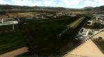
RAF Manston (ICAO EGMH) was an RAF station in the north-east of Kent, on the Isle of Thanet from 1916 until 1996. The site is now split between a commercial airport Kent International Airport (KIA) and a continuing military use by the Defence Fire Training and Development Centre (DFTDC), following on from a long-standing training facility for RAF firefighters at the Manston base.
I have represented the station as it was in 1944 leading up to its part in Operation Market garden and D Day. It was one of the few airfields installed with the Fog Investigation Dispersal Organisation (FIDO) system designed to remove fog from airfields by burning it off with petrol and I have represented this with the 8 fuel tanks at the 29 end of the main runway. I have laid the station out roughly according to an old map made in the mid 40s but I make no claims to the accuracy of the building I have used.
Posted Apr 20, 2016 05:45 by Terry Boissel