


5.68Mb (2746 downloads)
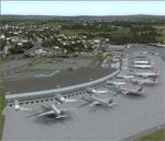
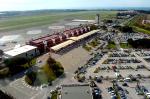
This scenery adds the new terminal and taxiways, and rebuilds the aprons and runway to provide a fully functioning AI traffic extension for runway 14. The airport is assigned a mean elevation, allowing it to blend naturally with the surrounding terrain, accurate landclass is provided for the entire island, and an optional GA traffic file is provided. This scenery is most effective when used in combination with the scenery by Max Kraus (instructions and links included in the readme file). It is optimized to fit seamlessly with FTX Global/Vector and should also be fully functional in all FSX configurations. The airport is updated to reflect current satellite imagery and positioning. Scenery was created using Airport Design Editor X v1.61.5298, SBuilderX 3.13, and the FSX Object Placement Tool. Scenery objects were added and modified from stock FSX scenery to resemble as closely as possible the actual airport. The FSX apron lights included are from the set created by Jim Dhaenens.
Posted Jul 19, 2015 23:37 by Carlyle Sharpe
90.29Mb (1007 downloads)
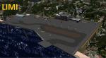
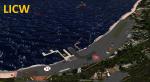
LIMI and LICW two Hydro Airports located in southern Italy, LIMI in Sicily to Messina and LICW in Calabria adjacent to the airport of Reggio Calabria both are fictions, there are but served as a starting point for flights of virtual V.A Virtual Over Italy. 2 projects by Nunzio Caltabiano (Voyager). Out many details of these two Hydro Airport especially the lights of water runway visible even in daylight.
Posted Jul 17, 2015 12:42 by Voyager
5.40Mb (5405 downloads)
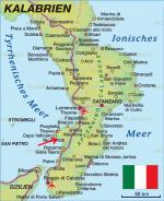
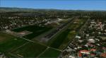
Airport Lamezia Terme "Sant Eufemia" (IATA: SUF, ICAO: LICA) is located in the district of the same name of the town of Lamezia Terme, is the main airport of Calabria and one of the first of the South for passenger traffic.
Posted Jul 15, 2015 11:49 by Voyager
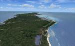
83.89Mb (1225 downloads)
(Fixed)
This package features full photoreal Scenery, manually reworked elevation, optional autogen and a highly detailed airfield with curved runway and 3D grass. Created by Gerome Bodden and David Hoeffgen
Posted Jul 15, 2015 10:13 by Daveh
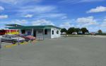
18.11Mb (4428 downloads)
Airport of Crotone S.Anna located in southern Italy in the Calabria region, is the third airport in the region.
Posted Jul 11, 2015 05:18 by Voyager
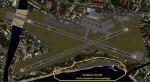
82.43Mb (3880 downloads)
Airport Reggio Calabria LICR, or Airport Strait, is the second airport in Calabria for number of passengers. It was the first airport built in the region, and is entitled to Reggio Calabria Tito Minniti, hero of the Royal Air Force
Posted Jul 11, 2015 04:56 by Voyager
(365 downloads)
Bingol Airport LTCU in the east of Turkey. Bingol Airport LTCU opened 2013. This airport was made using Airport Design Editor. Main terminal added default building of ADE. This also places a few objects from the default FSX scenery library. Compiled using Airport Design Editor.
Version LTCU 2015v1. By Hakan DAGHAN
Posted Jul 9, 2015 14:19 by Hakan DAGHAN
1.03Mb (564 downloads)
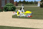
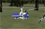
I managed to track down two FSX Wallis Autogyros to use in my scenery. I have also added the second parking place that I mentioned in my original ReadMe but never included.
Required files:
required file
Posted Jul 8, 2015 05:43 by Alf Denham
2.78Mb (1866 downloads)
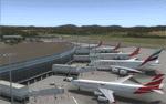
Building upon Menno Robert's original SEGU airport as a starting point, this project updates the coordinates of the airport, adds more visual detail, further expands aprons and the new terminal, and optimizes the scenery to fit seamlessly with FTX Global/Vector. This airport should also be fully functional in all FSX configurations. The airport is updated to reflect current satellite imagery and positioning. Scenery was created using Airport Design Editor X v1.61.5298, SBuilderX 3.13, and the FSX Object Placement Tool. Scenery objects were added and modified from stock FSX scenery to resemble as closely as possible the actual airport.
Thank you to Menno Robert for granting permission to edit his original SEGU file.
Posted Jul 4, 2015 12:51 by Carlyle Sharpe
12.50Mb (714 downloads)
Hakkari Airport LTCW new airport in the southeast of Turkey. Hakkari Airport LTCW opened May 2015. This airport was made using Airport Design Editor. Main terminal added default building of ADE. This also places a few objects from the default FSX scenery library. Compiled using Airport Design Editor. Version LTCW 2015v1. By Hakan DAGHAN
Posted Jun 28, 2015 10:15 by Hakan DAGHAN