


All Time Popular > Page 3633
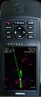
Garmin
GPSMAP195 Ver 1.0 FS2002
(Category: FS Gauges > FS Gauges)
0.18Mb (673 downloads)
Garmin
GPSMAP195 Ver 1.0 FS2002 GPS replacement.
Repackaged FS2002 GPS for use with General
Aviation aircraft. Same functions as standard
FS2002 GPS. Simple installation procedure.
Ike H Slack, Coyote Avionics Design. 182K
Posted Jun 23, 2008 14:18 by archive
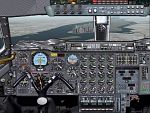
Photorealistic
Concorde panel for FS2000
(Category: FS2000 > Panels)
3.61Mb (673 downloads)
Photorealistic
Concorde panel for FS2000 (original by Chris Alevritis)
Now with permanent overhead panel and optimization of instrument
grouping. Added a new overhead panel, altitude callout, seatbelt/no
smoking signs, aircondition gauges and more. Readable gauges
with 1024x768 resolution. By Norbert Jaun. 3.8MB
Photorealistic
Concorde panel Fix for FS2000 (original by Chris Alevritis)
Panel fix for conc_pnl.zip. Fixes two gauges who's positions
were not properly set. 4K
Posted Jun 23, 2008 14:35 by archive
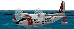
FS98
(Category: FS98 > Props)
0.72Mb (673 downloads)
FS98
USCG
HU16B Albatross with sound.
File size 750714
Posted Aug 24, 2009 06:42 by archive
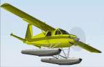
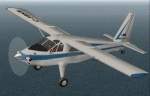
DHC-2
Mk lll Turbo Beaver 3 pack for FS2000.
(Category: FS2000 > Props)
6.46Mb (673 downloads)
DHC-2
Mk lll Turbo Beaver 3 pack for FS2000. Includes Float, Wheel,
and Wheel-Ski models. By Fred Banting with interior and panel
graphics by Yannick Lavigne. . In June 1965, following the success
of the popular DHC-2 Mk l Beaver, de Havilland Canada began
production of the Turbo Beaver Mk lll. Equipped with a Pratt
& Whitney PT6A-6 turbine of 550 hp, with later models using
the improved PT6A-20, this represented two aviation milestones.
The Turbo Beaver became the first single-engined utility aircraft
to be turbine powered, and the PT6A-6 was the first version
of what was to become the world's most popular small gas turbine
engine. 6.6MB
Posted Aug 24, 2009 06:46 by archive
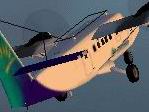
FS2002
Air Caraibes DHC6 Twin Otter
(Category: FS2002 > Props)
0.60Mb (673 downloads)
FS2002
Air Caraibes DHC6 Twin Otter.
Repaint of the Steven Grant DHC6 Twin Otter in the Air Caraibes
Livery. By Alexandre Cadel. 613K
Posted Aug 24, 2009 06:45 by archive
FS2004/2002 Vickers Viscount BUA Textures only.
(Category: FS2004 > Props)
0.47Mb (673 downloads)
FS2004/2002
Vickers Viscount BUA Textures only.
Vickers Viscount 833 wearing the last BUA livery. You must have
“Rick’s Viscount 800 to use this (here).
Repaint by Garry Russell. 479K
Required files:
required file
Posted Sep 8, 2009 23:29 by archive
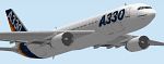
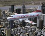
Airbus
A330-200 'House Colors'
(Category: FS98 > Civil Jets)
0.19Mb (673 downloads)
Airbus
A330-200 'House Colors' This Airbus A330-200 is painted
in de colors of the Airbus A330-200 prototype. Features Landing
lights, night textures, moving gear, flaps, elevators, ailerons,
rudder and spoilers. Repaint and night lights: Marco Rensen.
Camil Valiquette Original. 198K
Posted Jun 23, 2008 14:22 by archive
FS2000
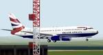
Aircraft - Boeing 737-400 British Airways New colors
(Category: FS2000 > Civil Jets)
0.24Mb (673 downloads)
FS2000
Aircraft - Boeing 737-400 British Airways New colors
for this British Airways 737-400 G-BVNM. Model features complete
moving parts including new AD2000 technics, double slotted flaps,
slats, spoilers, fans, steerable nose wheel and a new feature,
rolling wheels. Transparent cockpit and night lights/textures.
Uses default panel and sounds. The aircraft is painted in the
British airways 'Union Flag' livery. Original by Mike Stone.
Textures by John Sibley and Michel Melchior. 247K
Posted Jun 23, 2008 14:37 by archive
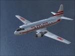
Martin 202A TWA Textures
(Category: FS2004 > Props)
1.62Mb (673 downloads)
FS9 TWA textures for Dee Waldron's Martin 202A / 404 .
These textures depict a TWA Martin 202A about 1951.
Required files:
required file
Posted Sep 29, 2009 23:01 by Gary Harper
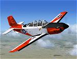
Alpha T-34C Turbo Mentor, TRAWING 4 Textures
(Category: FSX > Payware)
0.77Mb (673 downloads)
The aircraft represented is a T-34C with USMC markings. It is operated by Training Air Wing Four (TRAWING 4) at NAS Corpus Christi, Texas. These textures are intended for use with the Alpha Simulations T-34C Turbo Mentor payware aircraft package. Original release textures and this Repaint by Frank Safranek
Posted Nov 10, 2008 17:15 by Frank Safranek