


All Time Popular > Page 3704
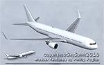
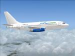
SkySpirit2010 Boeing 767-300 PAX Paint Kit
(Category: FS Design > Aircraft Paintkits)
86.42Mb (643 downloads)
FS2004/FSX SkySpirit2010 Boeing 767-300 PAX Paint Kit. SkySpirit2010 767-300 v5. Model features High resolution textures, dynamic flexing wings, body gear steering, nose gear steering, rudder lock, ground spoilers, low speed aileron locks at high speed, fully animated control surfaces, fully independent suspension, trim animation, opening passenger doors, animated tilting bogies, rolling wheels, animated thrust reversers with reverser block doors, detailed textures, full night lighting, crash affects, ground service vehicles and more. Model Designer Hiroshi Igami/Yosuke Ube. Flight Dynamics Designer Warren C. Daniel. Paintkit by Philip Foglar
Posted Apr 27, 2019 02:37 by chrisE
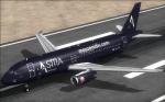
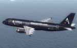
SMS A320 IAE Astra Textures
(Category: FSX > Payware)
5.92Mb (643 downloads)
This is an Astra Airlines Airbus, for the payware Overland SMS Airbus A320 IAE model. Textures only.
Posted May 17, 2015 00:56 by Dimitrios Moschos
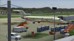
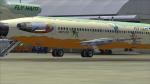
Fly Haiti Boeing 727-200 N29YV
(Category: FS2004 > Civil Jets)
70.48Mb (643 downloads)
Fly Haiti Boeing 727-200 N29YV is base at Port Au Prince Airport and fly by Guajira Airlines
crew on fs2004. Model by Vistaliners and texture bu Yankyvictor.
Posted Nov 27, 2014 22:22 by YANKYVICTOR
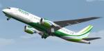
FSX/FS2004 Binter Canarias "La Geria" Boeing 787-8 (EC-FKQ) - Fictional Textures
(Category: FS2004 > Civil Jets)
9.72Mb (643 downloads)
Textures for the excellent TDS (Tenkuu Developers Studio) Boeing 787-8 model, in Binter Canarias "La Geria" livery, EC-FKQ (fictional). Texture only. The textures are saved in 32bit format for quality graphics. Its features are Opening doors & Cargo doors, detailed textures, accurate paint, dynamic shine & effects, dynamic flexing wings that respond to turbulence, fully independent suspension, trim animation, gear steering, accurate flight dynamics, spoiler animation, crash effects, reflective cockpit windows, transparent navigation light lenses and many more. For support visit Tenkuu Developers Studio's Facebook page: https://www.facebook.com/groups/266322650175225/
Posted Sep 10, 2013 07:36 by Stefan Bree / FSRepaintsGER, Tenkuu Developers Studio
Venezolana Boeing 737-232/Adv YV268T Textures
(Category: FS2004 > Civil Jets)
1.49Mb (643 downloads)
Boeing 737-232/Adv (cn 23099/1035) with new Venezolana(RAVSA)livery. Textures extensively reworked only for the Tinmouse II Project Boeing 737-200.
By Juan Ernesto Oropeza
Required files:
required file
Posted Nov 2, 2012 12:15 by Juan Ernesto Oropeza
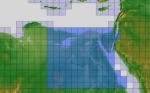
ASTER GDEMv2 30m mesh for Egypt pt4/6
(Category: FSX > Terrain Mesh)
95.93Mb (643 downloads)
There are six parts of this mesh to download as separate files.
ASTER GDEM Version 2 is a 30 metre definition DEM, its better than the version 1 data that ERSDAC, of Japan and NASA originally released, but it does have its limitations.
GDEM has been obtained from a satellite that uses stereoscopic infrared scanning cameras, this brings with it problems in the resultant data.....where it sees the tops of trees, buildings etc, as the ground terrain.
If you look at the jpg image with the terrain type errors shown as a graph, you will see that the only 'safe' terrain to use this data with - in FSX - is scrubland, or desert terrain.
Its hopeless in defining the terrain in places like Europe - with all the artificial structures, (buildings) and different types of woodland, so any mesh I create from this data won't include areas like that....it will be more desert type terrain, and scrubland.
I won't be doing Greenland because something about the ice around Greenland, (or any other land mass with ice) it creates false data.
It does give enough fine data to reveal railway lines, and some roads though.
This mesh has been made for FSX only.
Grateful thanks to ERSDAC, and NASA for making this data freely available to the public.
ASTER GDEM
Copyright (c) 2009 - 2011 Earth Remote Sensing Data Analysis Center (ERSDAC) All rights reserved.
Posted Feb 15, 2012 10:57 by Wayne Evans
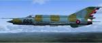
FSX MiG-21MF Cuban Textures: FAR665
(Category: FSX > Military)
5.03Mb (643 downloads)
Textures only for Ivan Jurcaga's FSX MiG-21MF. Represents MiG-21 serial 665, which sports an exotic blue/green camo pattern.
Required files:
required file
Posted Oct 23, 2011 06:17 by Owen Fentimen
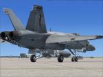
VRS Superbug NSAWC 114 ona Line Textures
(Category: FSX > Payware)
2.43Mb (643 downloads)
VRS Superbug NSAWC 114 CONA LINE textures.
Requires the payware VRS Superbug
repaint By Hornet202 Enjoy
Posted Aug 1, 2011 21:29 by Chris Hammons
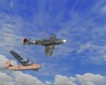
MAW P-38 North Africa set Historical HH 060
(Category: CFS3 > Missions & Campaigns)
0.04Mb (643 downloads)
P-38 North Africa set Historical:
Hauptmann Werner Schroer, Staffelkapitan 8./JG 27, Rhodes, 1943
*There are two sets of missions included*
A standard set for faster, newer computers..
And a Lite set for the older machines, Less objects and aircraft involved.
You have been moved to the Mediterranean, we are holding against Many Allied groups.. The Americans have moved in and are making life hard for the Luftwaffe.. You Must stem this tide..
Each mission is different for the other..
No two missions will fly the same, each time.
The random factors built into the
CFS3 game engine, allow for dynamic outcomes..
These are dedicated to Major Magee Thanks for your kind support and wonderful Aircraft..
I Hope all will enjoy these missions.
HouseHobbit
Posted Mar 27, 2011 13:55 by HouseHobbit
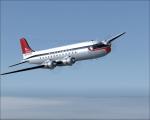
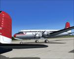
Northwest DC-4 Textures
(Category: FSX > Vintage)
1.36Mb (643 downloads)
FSX Northwest Orient textures for the JBK DC-4-1009 V.3 by Jens Kristensen. These textures represent Northwest's final livery for the DC-4 about 1958.
Textures by Gary Harper.
Required files:
required file
Posted Mar 22, 2011 21:37 by Gary Harper