


All Time Popular > Page 3801
FS2004
Viking 1 Hunting Clan Textures only.
(Category: FS2004 > Props)
0.99Mb (605 downloads)
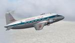
FS2004
Viking 1 Hunting Clan Textures only.
G-AHPB is seen here in the penultimate Hunting Clan livery which
went on to become the famous red tail scheme. After being retired
by it's last operator Autair it became one of three used as
a coffee bar in Holland. On the death of it's owner the three
aircraft were scattered and this one went first to Germany then
to Switzerland for preservation painted as D-BABY. Requires
the FSDS Viking model by Rick Piper (here):
Repaint by Garry Russell. 1MB
Posted Jun 23, 2008 14:26 by archive
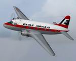
FS2004
Viking 3B Eagle Airways (final) Textures only
(Category: FS2004 > Props)
0.93Mb (605 downloads)
FS2004
Viking 3B Eagle Airways (final) Textures only. Wearing
a new Eagle livery that was to evolve into the most remembered
of all the Eagle liveries, that of British Eagle is G-AJPH
probably the most important British aeroplane to be almost
totally ignored it's place in history. Built as the jet powered
"Nene" Viking it was only ever intended to be a
proof of concept experimental machine. As such it was the
worlds first pure Jet airliner when it undertook a series
of passenger flights. After that work was finished it was
rebuilt as a standard Viking 1B for service with Eagle,later
being converted to a 3B. It was broken up in 1962.Requires
the FSDS Viking model by Rick Piper (here):
Repaint by Garry Russell. 953K
Posted Jun 23, 2008 14:26 by archive

American
Airline F100 V5
(Category: FS2000 > Civil Jets)
1.07Mb (605 downloads)
American
Airline F100 V5 This Fokker 100 is an update of the previous
versions, that include new 3D engines, full moving parts (except
tail), 16 parts sided fuse and engines, 3D cockpit, 3D pilots,
night lightnings, 512*512 textures and ... a fully FS2000 flight
model. No need to have the previous versions to use it. Visual
model by Pascal Linder(FFG). Flight model by Hervé SORS. 1.1MB
Posted Jun 23, 2008 14:37 by archive
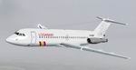
FS2004
BAC One-Eleven 476 Loganair Textures only
(Category: FS2004 > Civil Jets)
0.56Mb (605 downloads)
FS2004
BAC One-Eleven 476 Loganair Textures only.
Although in the UK the type 475 was a rarity, G-AZUK certainly
tried to make up for it by appearing just about anywhere. April/May
1989 saw it in service with Baltic where it acquired the bands
on the forward fuselage. That summer saw it in service with
Loganair with only the logo painted out on the fin and Loganair
titles replacing those of Baltic. The lack of Loganair paint
was understandable as it was hired on an almost monthly basis
only to cover for the late delivery of ordered BAe ATP. It went
on to serve with RyanAir with only that carrier’s titles and
logo on this basic scheme. Requires the BAC One-Eleven 475HK
model by David Maltby
here. Repaint Garry Russell. 577K
Posted Jun 23, 2008 14:30 by archive
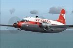
Vickers Viking AVIAMEER Textures
(Category: FS2004 > Vintage)
2.54Mb (605 downloads)
This Vickers Viking is in the livery of Belgian operator AVIAMEER and it was the sole airplane of that company.
They were founded in October 1957 but had to cease operations already in the summer of 1960.
AVIAMEER flew general charter flights and inclusive tours within Europe and the Middle East and had it's home base at the airport of Antwerp, Deurne.
Needed file: FSDS Vickers Viking by Rick Piper
Required files:
required file
Posted Jun 28, 2010 07:16 by Jaap de Baare
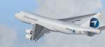
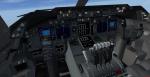
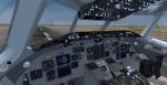
FSX/P3D Boeing 747-400F Challenge Airlines package
(Category: FSX > Civil Jets)
82.17Mb (604 downloads)
FSX/P3D Boeing 747-400F Challenge Airlines package. Challenge is a Belgian airline that started flying in 2019 and is based at Liege Airport. Challenge currently have 2 Boeing 747-400F flying to the USA, China and European countries.
High quality Project Opensky Boeing 747-400f FSX native model with the much improved Boeing 747 internal model (VC) from Alejandro Rojas Lucenda (Manual included). Model includes ground cargo servicing, stairs (FSX - Go to Views - Instrument Panel -Posky Utility. P3D go to Vehicle - Instrument Panel -).
Added 747 sounds, edited views, panel.
Thank you to Project Opensky/Skyspirit/TDS for their fantastic contribution to the worldwide flight simulation community.
Also includes the Boeing 747 VC textures upgrade. Added wing views.
Textured and assembled for P3D v5 by Chris Evans. Should also work in FSX and previous P3D versions.
Posted Apr 25, 2022 06:45 by chris evans
FSND McDonnell Douglas MD-83 | Gray Cockpit
(Category: FSX > Civil Jets)
4.05Mb (604 downloads)
This version of the FSND MD-83 gives you the opportunity of a different color scheme in your cockpit. Requires the FSND MD-83 Freeware addon.
Required files:
required file
Posted Jan 28, 2018 15:07 by Tayler Forster

FSDS T6 North American Quad Package Texture Fix
(Category: FSX > Props)
3.66Mb (604 downloads)
Fix for my bad spelling mistake on the wing
of the Aeroshell T6. Just replace old texture folder with new one. I'm of for a overdue
visit to the opticians!
Posted Apr 10, 2016 12:33 by Stephen Browning
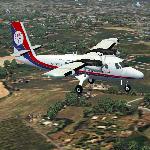
FSX/FS2004 DHC6 Dan-Air Met Textures
(Category: FS2004 > Props)
1.99Mb (604 downloads)
Textures for the Premaircraft Premier Aircraft Design, Project Globe Twotter DHC-6 Long Nose Twin Otter.
Towards the end of Dan-Air's operations before the British Airways takeover, many of the HS748 Link City routes were operated by Metropolitan Airways DHC6-300 aircraft. This is a depiction of G-BELS in DA/Metro colours. Should work in both the FS2004 and FSX versions
Required files:
required file
Posted Feb 10, 2016 13:46 by Kit Yardley
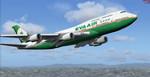
Boeing 747-400 Eva Air
(Category: FS2004 > Civil Jets)
13.31Mb (604 downloads)
Boeing 747-400 Eva Air. model by Project Opensky. Textures by RyanC
Posted Jan 28, 2016 11:14 by chrisE