



All Time Popular > Page 4346

FSX Japan Airlines Airbus A350-900
(Category: FSX > Civil Jets)
10.42Mb (427 downloads)
FSX Japan Airlines Airbus A350-900 AGS V6.
New Night lights reflection.
New Animated Ground Servicing.
New static displays.
New winglets.
New wing root.
New landing / taxi soft light beams.
New 2D panel.
Model design and paint by Camil Valiquette. ( CamSim )
Posted Nov 2, 2019 01:45 by Camil Valiquette

GOBD, Dakar, Senegal
(Category: FSX > Scenery)
2.33Mb (427 downloads)
ADEX based scenery GOBD, Dakar in Senegal
Posted Sep 20, 2018 19:15 by Sergey Stoyanov


V1 Buzz Bomb for x-plane 4.65
(Category: X Plane > Military)
0.03Mb (427 downloads)
The V-1 was developed at Peenemunde Army Research Center by the Nazi German Luftwaffe during the Second World War. During initial development it was known by the codename "Cherry Stone". The first of the so-called Vergeltungswaffen series designed for terror bombing of London
Posted Mar 8, 2015 06:00 by Next day plane
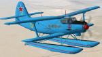
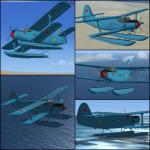
FS2004/FSX Antonov AN-2V URSS Navy Textures
(Category: FSX > Props)
2.45Mb (427 downloads)
URSS Navy colours repaint for AN-2V Floatplane. FS2004/FSX. This is a repaint in URSS Navy colours of Tim Conrad's wonderful AN-2V 'annushka' floatplane.
These are textures only.
Required files:
required file
Posted Dec 25, 2012 22:29 by Enrique Medal
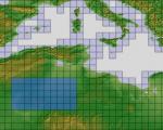
ASTER GDEMv2 30m mesh North Africa Pt9 incl Algeria.
(Category: FSX > Terrain Mesh)
230.92Mb (427 downloads)
There are Eighteen (18) parts of this mesh to download as separate files.
ASTER GDEM Version 2 is a 30 metre definition DEM, its better than the version 1 data that ERSDAC, of Japan and NASA originally released, but it does have its limitations.
GDEM has been obtained from a satellite that uses stereoscopic infrared scanning cameras, this brings with it problems in the resultant data.....where it sees the tops of trees, buildings etc, as the ground terrain.
If you look at the jpg image with the terrain type errors shown as a graph, you will see that the only 'safe' terrain to use this data with - in FSX - is scrubland, or desert terrain.
Its hopeless in defining the terrain in places like Europe - with all the artificial structures, (buildings) and different types of woodland, so any mesh I create from this data won't include areas like that....it will be more desert type terrain, and scrubland.
I won't be doing Greenland because something about the ice around Greenland, (or any other land mass with ice) it creates false data.
It does give enough fine data to reveal railway lines, and some roads though.
This mesh has been made for FSX only.
Grateful thanks to ERSDAC, and NASA for making this data freely available to the public.
ASTER GDEM
Copyright (c) 2009 - 2011 Earth Remote Sensing Data Analysis Center (ERSDAC) All rights reserved.
ASTER GDEM is a product of METI and NASA.
Posted Apr 17, 2012 03:16 by Wayne Evans
-2.jpg-thumb.jpg)
FSX Flight Plans for Current Low Altitude Military Training Routes for the US Territories of Guam and Puetro Rico
(Category: FS Navigation > Flight Simulator Navigation)
1.56Mb (427 downloads)
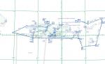
FSX Flight Plans for current low altitude military training route for the US Territories of Guam and Puetro Rico.
This package includes 9 individual flight plans for IFR, VFR and Slow Speed Routes. These are great routes for B-52, F-111, B-1B, B-2 A6, A4, Vulcan and any fighter or bomber enthusiasts. Of course you can fly the route with any aircraft of your choice. Also included in this package are two spectacular gauges by Karol Chlebowski for TFR flying and Pave Tack which ncludes many advanced features for bombing,navigation and reconnaissance. these two gauges will greatly enhance your ability to fly these challenging routes and are a great companion of the flight
plans. Another option is to download Version 2.1 of my mini panel which has all this functionality and more.
Posted Sep 16, 2011 03:21 by Bill McClellan

TRV RB-66
(Category: CFS2 > Post WW2 Aircraft)
13.12Mb (427 downloads)
The TRV RB-66B is a complete conversion of the FS2004 aircraft by Virtavia (virtavia.com). This includes the original textures. The 2D and DVC have been re-gauged as close to the original as available CFS2 gauges will allow. The DP, CFG and AIR files and the
pilot figure (SID) are by myself. Sound is aliased to Lear45, which is included. Like most large aircraft, careful use of pitch (elevator) trim must be exercised on takeoff, for cruise and landing. The aircraft is unarmed except for her tail turret.
Posted Mar 12, 2011 00:31 by Tom Sanford, Tango_Romeo
Asheville, NC
(Category: FSX > Scenery)
0.02Mb (427 downloads)
Asheville, NC upgrade from stock FSX airport using satellite imaging and my knowledge of the airport. David Hinson
Posted Sep 23, 2010 09:25 by David Hinson

GZR_TARGET
ISLAND FOR CFS II.
(Category: CFS2 > Scenery)
0.43Mb (427 downloads)
GZR_TARGET
ISLAND FOR CFS II. The Island has a 500m concrete square target.
It is marked with a grid with 25 m intervals. It has a center mast
for alignment. Near to GZR 2001 and GZR Remote. You can enable or
disable in scenery menu. By Ric Charlebois-GZR Frenchy. 442K
Posted Jun 10, 2008 11:30 by archive

CFS1-Campaign-Aussi
Jungle base
(Category: CFS1 > Missions & Campaigns)
1.85Mb (427 downloads)
CFS1-Campaign-Aussi
Jungle base. Made with CFS mission editor version 3.03 By
A.F.Scrub. 1.9MB
Posted Jun 10, 2008 11:32 by archive