


All Time Popular > Page 4472
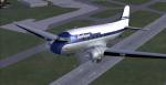
Awesum4sum DC-3 Southeast Airlines Textures
(Category: FSX > Props)
4.19Mb (379 downloads)
Southeast Airlines linked cities across Tennessee from 1958 until 1961 flying DC-3s purchased from United and two Convair 240s.
Southeast Airlines textures for the FSX default DC-3 aircraft by Microsoft/Aces and modified by James Eden and Jon Murchison.
These textures require AWESUM4SUM.zip modification to the default FSX DC-3
Textures by Gary Harper.
Required files:
required file
Posted Jul 13, 2013 14:43 by Gary Harper

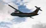
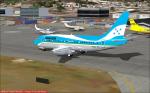
Flight 1 ATR72-500 Air Nostrum Textures
(Category: FSX > Payware)
7.35Mb (379 downloads)
Textures for the payware Flight 1 ATR72-500 Air Nostrum Reg: EC-LQV
Posted Mar 4, 2013 14:27 by Trino Rojas
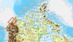
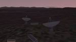
FSX Canadian CDED mesh above 60 degrees Lat 19 metre resolution Pt45, block 116.
(Category: FSX > Terrain Mesh)
152.31Mb (379 downloads)
As Raimondo Taburet hasn't processed the CDED files above 60 degrees latitude for Canada, well here are the ones I have processed.
There isn't any data available from geobase in some of the blocks above 60 degrees latitude, these are blocks: 15, 17, 18, 28, 108, 109, 118, 119.
See jpg for coverage.
Thanks go to Geobase (Copyright) Canada for the availability & public use of this data.
Posted May 20, 2012 03:43 by Wayne Evans
ASTER GDEMv2 30m mesh North Africa Pt6 incl Chad, Niger
(Category: FSX > Terrain Mesh)
215.66Mb (379 downloads)
There are Eighteen (18) parts of this mesh to download as separate files.
ASTER GDEM Version 2 is a 30 metre definition DEM, its better than the version 1 data that ERSDAC, of Japan and NASA originally released, but it does have its limitations.
GDEM has been obtained from a satellite that uses stereoscopic infrared scanning cameras, this brings with it problems in the resultant data.....where it sees the tops of trees, buildings etc, as the ground terrain.
If you look at the jpg image with the terrain type errors shown as a graph, you will see that the only 'safe' terrain to use this data with - in FSX - is scrubland, or desert terrain.
Its hopeless in defining the terrain in places like Europe - with all the artificial structures, (buildings) and different types of woodland, so any mesh I create from this data won't include areas like that....it will be more desert type terrain, and scrubland.
I won't be doing Greenland because something about the ice around Greenland, (or any other land mass with ice) it creates false data.
It does give enough fine data to reveal railway lines, and some roads though.
This mesh has been made for FSX only.
Grateful thanks to ERSDAC, and NASA for making this data freely available to the public.
ASTER GDEM
Copyright (c) 2009 - 2011 Earth Remote Sensing Data Analysis Center (ERSDAC) All rights reserved.
ASTER GDEM is a product of METI and NASA.
Posted Apr 11, 2012 08:18 by Wayne Evans
Boeing 737-2K6Adv SAHSA Honduras HR-SHA Textures
(Category: FS2004 > Civil Jets)
1.18Mb (379 downloads)
This work is dedicated to all the people who flew with SAHSA, and for all of us that would like to see the blue livery and the five stars flying again to and from Honduras.
SAHSA was the international airline of Honduras since 1945 thru 1994. It served several destinations in North, Central and South America from its hub in Toncontin International Airport in Tegucigalpa, Honduras. HR-SHA was received in October 1974, and was the first (and only) brand new Honduran 737-200, received a few months after TAN´s HR-TNR.
Required files:
required file
Posted Jan 4, 2012 21:04 by Oscar Elvir Vasquez
Monarch Bristol Britannia Textures
(Category: FSX > Vintage)
3.96Mb (379 downloads)
FSX Monarch Textures for the Bristol Britannia by Jens Kristensen. Requires Britanniax.zip for aircraft.
Textures by Gary Harper.
Required files:
required file
Posted Jan 19, 2011 18:24 by Gary Harper
FS2002/CFS2
Scenery -- Area B -- Railroad Valley, NV.
(Category: CFS2 > Scenery)
2.18Mb (379 downloads)
FS2002/CFS2
Scenery -- Area B -- Railroad Valley, NV.
This fictional scenery includes Aeroworks Flight Center #4 located
in Railroad Valley, Nevada and located 25 miles north of the fictional
Area A scenery (afc3v2jt.zip). The base acts as a weapons development
center and storage facility and has a 10,000 foot runway with ILS
approaches. The scenery is comprised almost entirely from custom designed
scenery macros. and works in conjunction with FS2002's AFD and shows
up on FS2002 GPS. Requires Airport 2.10 and VOD 3.0 textures. Scenery
and static aircraft by Jason L. Terry. 2.2MB
Posted Jun 10, 2008 11:30 by archive
CFS2
Scenery-Wales 3.75 Arc Second Mesh Terrain
(Category: CFS2 > Scenery)
0.72Mb (379 downloads)
CFS2
Scenery-Wales 3.75 Arc Second Mesh Terrain Enhaced mesh terrain
of Wales. Created using FsTrn and Microsoft Terrain SDK. (See also
NFATRN.ZIP and SEENGTRN.ZIP). By Daniel Hamblin. 753K
Posted Jun 10, 2008 11:30 by archive
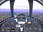
CFS
Panel for the P-80a Shooting Star
(Category: CFS1 > Panels)
0.73Mb (379 downloads)
CFS
Panel for the P-80a Shooting Star based on Illustrations in the
Pilot's Manual. Compass, fuel meter & ammo counter; Jerry Beckwith.
Homing device & GPS; Chuck Dome. Features Full Screen HUD & Crisp-O-Vision
gauges. By Mike Eustace . 767K
Posted Jun 10, 2008 11:32 by archive
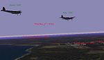
Resistance
Rescue
(Category: CFS1 > Missions & Campaigns)
0.09Mb (379 downloads)
Resistance
Rescue My first uploaded CFS 1 Mission.(Yes OK a bit late,
but I'm a slow starter.) Fly a Mosquito FBVI to destroy a Gestapo
HQ and a few other German assets. Stock CFS 1 aircraft except the
Mosquito which is included. By Terry Baldwin. 93K
Posted Jun 10, 2008 11:32 by archive