


All Time Popular > Page 4474
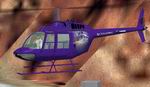
FS2002
Repaint of the Default FS2002 Bell 206B Texture only Repainted
in 'Simviation' House Colors
(Category: FS2002 > Helicopters)
1.25Mb (379 downloads)
FS2002
Repaint of the Default FS2002 Bell 206B Texture only Repainted
in 'Simviation' House Colors.
Repaint By Robert "Hawk". 1.3MB
Posted Jun 23, 2008 14:34 by archive
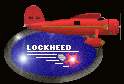
FS98
Aircraft and Panel Package VEGA PROJECT Part 0ne
(Category: FS98 > Vintage)
1.40Mb (379 downloads)
FS98
Aircraft and Panel Package VEGA PROJECT Part 0ne This bright
red Lockheed Vega 5B was flown by Amelia Earhart on two history-making
flights in 1932: the first solo flight by a woman across the
Atlantic and the first nonstop solo flight by a woman across
the United States.This package includes airplane,sounds and
panel.Original aircraft by Scott A. Dommin. Aircraft modifications
for FS98 and Vega instrument panel by J.L.Stubbs. 1.4MB
Posted Jun 23, 2008 14:20 by archive
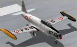
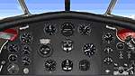
FS2000
Lockheed T33 A "Shooting Star"
(Category: FS2000 > Military)
1.46Mb (379 downloads)
FS2000
Lockheed T33 A "Shooting Star" This model is a reproduction
of the famous american aircraft trainer. Here is an example
textured to represent an aircraft of Italian Air Force "Scuola
Aviogetti Amendola" operative during 1959-60' The 3D model made
with FSDS, features full moving parts, airbrake , recessed wheel
wells, nose wheel steering and pilots in a virtual cockpit.
File contains also a panel. Visual Model by Massimo Taccoli.
Textures by Gerardo Taccoli Air and panel file by Bruce Thorson.
Original bitmap panel by Phil Perrot. 1.5MB
Posted Jun 23, 2008 14:36 by archive
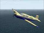
FS2000
Replacement textures for the default Mooney
(Category: FS2000 > Props)
0.12Mb (379 downloads)
FS2000
Replacement textures for the default Mooney. Livery yellow
& blue. By Prasong. 125K
Posted Aug 24, 2009 06:46 by archive
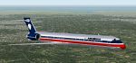
AeroMexico
(Fictional) MD-90-30 v4.0 For FS 2000
(Category: FS2000 > Civil Jets)
0.20Mb (379 downloads)
AeroMexico
(Fictional) MD-90-30 v4.0 For FS 2000. This aircraft is
painted in the colours of AeroMexico they do not have a MD90
but I decided to paint one. Animation: Bob Klemm/PFG, Dean Chamblee/PFG
FDE: Chris Grall/PFG. Original By Esa Kaihlanen & Repaint by
Mark Harrison. 206K
Posted Jun 23, 2008 14:36 by archive
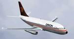
Orion
Airways 737-200 for FS2002.
(Category: FS2002 > Civil Jets)
2.15Mb (379 downloads)
Orion
Airways 737-200 for FS2002.
This is a repaint of the yeodesigns Gmax 737-200 v2 model in
the Orion Airways livery. This UK based airline regularly flew
holiday charter flights to europe during the 80's before being
bought by Britannia in 1988. This repaint depicts G-BKHO and
has been kept accurate as possible to the original and includes
a voicepack to add the Orion callsign to ATC. Repainted by Ricky
Sharma. 2.2MB
Posted Jun 23, 2008 14:34 by archive
FS2002
767-300ER Royal Brunei Airlines
(Category: FS2002 > Civil Jets)
1.23Mb (379 downloads)
FS2002
767-300ER Royal Brunei Airlines with VISIT BRUNEI sticker
FS2002 767-300ER Royal Brunei Airlines with VISIT BRUNEI sticker
repaint. Requires rb767er.zip to install. Original model by
Project Opensky. Painted by A. I. Hj. Jumat. 1.2MB
Posted Jun 23, 2008 14:34 by archive
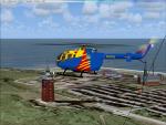
Bo-105 D-HFHV German Rescue Texture
(Category: FS2004 > Helicopters)
2.60Mb (379 downloads)
Bo-105 D-HFHV German Rescue textures only for the Bo-105 by Guther Kram
Required files:
required file
Posted Feb 17, 2010 07:04 by benimix
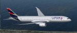

FSX/P3D Boeing 787-9 LATAM Brasil package
(Category: FSX > Civil Jets)
79.77Mb (378 downloads)
FSX/P3D Boeing 787-9 LATAM Brasil package. Based in Sao Paulo, LATAM Brasil is part of the LATAM Group and currently operates 1 Boeing 787-9 aircraft.
The high quality Boeing 787-9 and paint kit from TDS. The VC is the Erik Bender great adaption of the X-plane Mariano Gonzalez (MagKnight)'s 787 VC.
TDS high spec. native FSX Boeing 787-9 model. See Document to get the best out of the VC and FMC.
Textured, assembled and tested in P3D v5 by Chris Evans. Should also work in earlier P3D & FSX.
Posted Nov 17, 2025 13:59 by chris evans
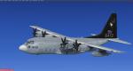
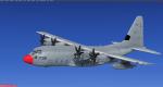
P3D/FSX Captain Sim KC-130 Repaint Pack
(Category: Prepar3d > Payware)
19.38Mb (378 downloads)
This is a Captain Sim KC-130 repaint pack. It will work in FSX or P3D but will require something more then drop in for FSX. Entries included for Stock KC-130 for FSX, P3D KC-130, and Scorches KC-130 mod.
The included night maps may or may not work as I did change some things on my model to make them user controlled. If used with Scorches mod they should work fine.
Credit goes to Captain Sim for the base KC-130 paint, the rest was modified by me, Delta. Do not reupload or repack!
Posted Jun 22, 2025 05:17 by Delta