


All Time Popular > Page 4517
FS2004
FS-COF Landclass for Puyallup Wa.
(Category: FS2004 > Scenery)
0.08Mb (366 downloads)
FS2004
FS-COF Landclass for Puyallup Wa. LC1s0.zip
This landclass is for the Puyallup South Hill area and surrounding
areas. It includes Lipoma Firs golf course on the south of 1sO,
thun feild. Also current building in the Orting valley. It also
extends west to Yelm and south to Eatonville and the hills.
. LC1s0.zip This landclass is for the Puyallup South Hill area
and surrounding areas. It includes Lipoma Firs golf course on
the south of 1sO, thun feild. Also current building in the Orting
valley. It also extends west to Yelm and south to Eatonville
and the hills. Bob LeSage. 81K
Posted Jun 23, 2008 14:25 by archive
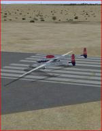
FS98
Travel Air "Mystery Ship" air racer
(Category: FS98 > Vintage)
0.09Mb (366 downloads)
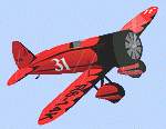
FS98
Travel Air "Mystery Ship" air racer the Travel Air Mystery
Ship was Flown by Doug Davis to first place in the 1929 Thompson
Trophy race beating the best the military had to offer. This
model has full moving parts and prop animation. By Paul Grubich.
93K
Posted Jun 23, 2008 14:19 by archive
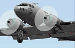
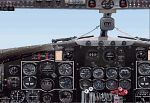
n
upgrade for FS2000 of the most authentic DC-3
(Category: FS2000 > Vintage)
11.56Mb (366 downloads)
An
upgrade for FS2000 of the most authentic DC-3 flight sim
package. New photo-real dual panel, quadrant, and overhead
panel. All new radios and auto pilot located on the overhead.
Features realistic starting system. Sound pack, start-up and
shutdown, recorded from actual DC-3. Real DC-3 flight dynamics.
Illustrated manual. Self-extracting archive for easy, automatic
installation. By Bill Rambow, Roy Chaffin, and Jan Visser.
12MB (!)
Alternative
download point.
Posted Jun 23, 2008 14:34 by archive

FS2000
and FS98 Boeing 727-200, Iberia.
(Category: FS98 > Civil Jets)
0.10Mb (366 downloads)
FS2000
and FS98 Boeing 727-200, Iberia. V.2.0 Full Moving Parts
(FMP) and Full Precision Design (FPD). Rudder, elevators, ailerons,
flaps, slats, Krueger flaps, spoilers, landing gear, undercarriage
open/close sequence, landing lights, steerable nose wheel, tail
skid, 12 sides fuselage and engines design, semi-photorealistic
textures, no huskitted engines, trasnparent windshield, and
much more! By Everardo Diaz. 108K
Posted Jun 23, 2008 14:22 by archive
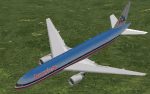
FS2000
American Boeing 777-200
(Category: FS2000 > Civil Jets)
0.28Mb (366 downloads)
FS2000
American Boeing 777-200. Features new High Quality & Night
lighting textures including the engine nacelles and full moving
parts. By OMC'99 from Camille Valiquette original. 287K
Posted Jun 23, 2008 14:37 by archive
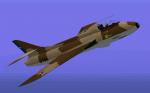
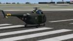
Hawker Hunter MK-71 (desert colors)
(Category: CFS1 > Modern Aircraft)
1.83Mb (366 downloads)
FS98/CFS Hawker Hunter MK-71 (desert colors).
Chilean Air Force - Fuerza Aerea de Chile.
This repaint depicts Chilean Air Force Hawker Hunter J-704 as it looked in 1978 when serving With Grupo Nº9 at Cerro Moreno airbase.
Original :Mike Hill
CFS chilean version with moving parts, new panel, damage profile and accurate colors on non textured parts: Edmundo Abad Feb. 2010.
Posted Mar 1, 2010 06:29 by Edmundo Abad

Update for FSX of the ERJ-140
(Category: FSX > Civil Jets)
22.52Mb (365 downloads)
This is an update for FSX of the ERJ-140 by Project Open Sky. I have given it the panel I used in the ERJ-135 update with a change to the background picture of the 2D panel; I have added the other 3 wheels and corrected, as necessary, any of the other 34 contact points; and I updated the flight dynamics.
Posted Jun 3, 2021 15:29 by Bob Chicilo
ALPHA Sikorsky S-55 adapted
(Category: Prepar3d > Helicopters)
45.62Mb (365 downloads)
Adaptions to Virtavia freeware Sikosrky S-55.
I could not resist to make some adadptions to this great helicoptor although already posted on this site,
This is the whole aircraft and comes with:
- New sound set.
- More liveries, converted to DDS DXT5 format.
- CockpitSounds with dedicated new XML profile.
- Fixed Radio gauge.
- Better lights.
- Slightly improved VC.
For more Info: see WhatIsThis.txt
For all credits: see ALPHA_Sikorsky_S-55_FSX.txt in the Docs folder.
For previewing screenshots preview this archive.
Tested in Prepar3D v4.5
Posted Jan 30, 2021 15:11 by Flanker256
Rutan Global Flyer mission
(Category: FSX > Missions)
0.34Mb (365 downloads)
This is meant to be a small portion of the solo flight around the world made in this Rutan Scaled Composites&FS-WowAir global_flyer from Salina Mun airport in Salina and fly to Kansas City Intl airport in Kansas City, USA.
Aircraft is a FS2004 aircraft from Simviation. It seems to fly well in FSX.
Posted Oct 8, 2017 12:35 by Don Olsson
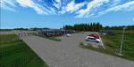
FSX/P3D Scenery - Skive Lufthavn, EKSV, Denmark
(Category: FSX > Scenery)
45.16Mb (365 downloads)
FSX Scenery-- Skive Airport EKSV
Danish VFR airport 10 km southeast of
Skive city, in the middle of Jutland in
Denmark. Airport has lighted asphalt runway
so can be used 24 hours.I have designed it
with photoreal background, with summer
and winter seasons. It has animated wind-
socks and wind gauges. All objects are
designed in FSDS except for a few ones.
By Otto Knudsen
Posted May 9, 2017 07:23 by Otto Knudsen