


All Time Popular > Page 4541

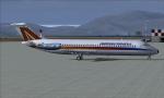
Sky Simulations DC-9 Aermediterranea Textures
(Category: FS2004 > Payware)
1.05Mb (359 downloads)
FS9/FSX Aermediterranea McDonnell Douglas DC-9-32, registration I-ATIQ, ver. 1.0. Textures only for the payware Sky Simulations DC9
Posted Apr 19, 2010 18:29 by Stefano Meneghini

Boeing 747-300 JAL "Resocha"
(Category: FS2004 > Civil Jets)
21.35Mb (358 downloads)
FS2004 JAL Boeing 747-300 PW, registration JA8183, in Reso'cha livery. Model by Project OpenSky. Repaint by AJ Nikoley.
Posted May 7, 2021 16:27 by Farlaens123
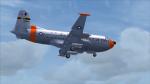
FSX/P3D USAF Douglas C-124C MATS 20956 Textures
(Category: FSX > Military)
4.74Mb (358 downloads)
This is a repaint of the Douglas C-124C in USAF colors. The freeware Douglas C-124C for FSX by Jens Kristensen (JBK) is needed for this repaint. This repaint depicts USAF C-124C of the Military Air Transport Service - MATS. Serial: 52-0956 of the 9th Air Transport Squadron (ATS). It was used in the South Polar Expedition in 1958. On retirement, it was shipped to the Boneyard at Arizona (MASDC) as CQ325 on Dec 17, 1972. Textures are 32bit DDS. This repaint was tested on FSX-SE. It should also work on FSX, and P3Dv1-4.
Required files:
required file
Posted Nov 12, 2019 09:46 by Ted Giana
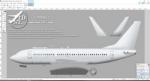
FS2004/FSX TDS Boeing 737-700/700F/C40 Paint Kit
(Category: FS Design > Aircraft Paintkits)
5.83Mb (358 downloads)
FS2004/FSX TDS Boeing 737-700/700F/C40 Paint Kit, developed by Tenkuu Developers Studio (TDS).
Posted Apr 27, 2019 04:39 by chrisE
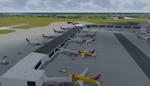
Louis Armstrong New Orleans Intl. Airport
(Category: Prepar3d > Scenery)
7.02Mb (358 downloads)
Louis Armstrong New Orleans Intl. Airport for P3D. Originally created for FSX, this airport has been converted to work in P3D. Several improvements have been made to the default airport. The default terminal buildings have been replaced with buildings created in FSDS; aircraft gates have been correctly coded using Airport Design Editor 1.76.6582; a new airport vehicle network has been built; extra fuel trucks have been added throughout the airport; the tower view has been changed to display from the roof of the control tower; all taxiway designators are correct and all taxiway signs are correctly placed and named; there is the option to open both runways to AI traffic; the FedEx and UPS cargo areas are displayed; and Jim Dhaenen's excellent ramp lights are also included. Please refer to the README FIRST.txt file to insure proper installation of all files. Created by Patrick Finch
Posted Apr 2, 2018 01:32 by Uploader
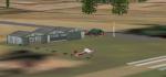
FSX Scenery - Firestorm Ranch
(Category: FSX > Scenery)
4.97Mb (358 downloads)
Firestorm Ranch serves as a headquarters for Firestorm Airshows, a solo aerobatic display flying the Aeroworks ARX-5R Coyote (ARX5R_jt.zip). It's layout caters to training and flying aerobatic maneuvers and practicing for airshows. It is located on public lands in Carrizozo, NM just north of White Sands. It has it's own solar farm and water tower along with all manner of general aviation maintenance and hangars. It's 3500ft runway can handle airplanes up to and including a Learjet or DC-3. There is also a non-standard air racing course to the east on Cub Mountain, south of Carrizozo. Macro's by Joshua B. Nyhus and Jason L. Terry. Scenery by Austin K. Gardner
Posted Nov 20, 2015 22:19 by Austin Gardner
Dipolog, Philippines, AFCAD file
(Category: FSX > Scenery)
0.00Mb (358 downloads)
Upgraded version of the default Dipolog Airport, Philippines, in FSX
Posted Jun 3, 2015 05:24 by Jonathan
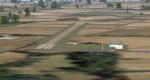
EKBR Braedstrup Denmark Scenery for fsx
(Category: FSX > Scenery)
0.29Mb (358 downloads)
This Danish Scenery for FSX contains EKBR Braestrup airfield in Denmark. Scenery is made with Airport Design Editor and Fsx Sdk Opt. Contains runway, gps fix, and buildings.
Posted Mar 29, 2014 13:55 by Henrik Hansen
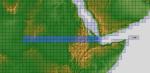
ASTER GDEMv2 30m mesh for Sudan & the Horn of Africa pt5
(Category: FSX > Terrain Mesh)
185.24Mb (358 downloads)
There are Eleven (11) parts of this mesh to download as separate files.
ASTER GDEM Version 2 is a 30 metre definition DEM, its better than the version 1 data that ERSDAC, of Japan and NASA originally released, but it does have its limitations.
GDEM has been obtained from a satellite that uses stereoscopic infrared scanning cameras, this brings with it problems in the resultant data.....where it sees the tops of trees, buildings etc, as the ground terrain.
If you look at the jpg image with the terrain type errors shown as a graph, you will see that the only 'safe' terrain to use this data with - in FSX - is scrubland, or desert terrain.
Its hopeless in defining the terrain in places like Europe - with all the artificial structures, (buildings) and different types of woodland, so any mesh I create from this data won't include areas like that....it will be more desert type terrain, and scrubland.
I won't be doing Greenland because something about the ice around Greenland, (or any other land mass with ice) it creates false data.
It does give enough fine data to reveal railway lines, and some roads though.
This mesh has been made for FSX only.
Grateful thanks to ERSDAC, and NASA for making this data freely available to the public.
ASTER GDEM
Copyright (c) 2009 - 2011 Earth Remote Sensing Data Analysis Center (ERSDAC) All rights reserved.
ASTER GDEM is a product of METI and NASA.
Posted Mar 17, 2012 09:36 by Wayne Evans
Boeing 747 Madonna Textures
(Category: FSX > Civil Jets)
1.45Mb (358 downloads)
FSX default Boeing 747 with the singer 'Madonna' pictures pasted on to the default textures. Textures only.
Posted Dec 28, 2011 17:57 by Johnny Soto