


All Time Popular > Page 4593
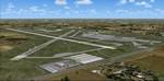
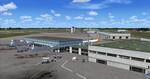
KCID, Eastern Iowa Airport, USA
(Category: FSX > Scenery)
3.02Mb (343 downloads)
KCID, Eastern Iowa Airport, USA, for FSX.
New setup of another airport I came across in one of my virtual flights. It is located 06 miles SW of Cedar Rapids, Iowa.
Tim van Ringen
Posted Apr 28, 2018 05:42 by uploader
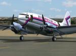
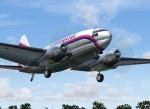
FS2004/FSX Curtiss C-46 Commando Aeropostal YV-C-AMN Textures
(Category: FS2004 > Props)
2.56Mb (343 downloads)
Curtiss C-46 Commando, registration YV-C-AMN, cargo role, wearing the colors of Linea Aeropostal Venezolana (Aeropostal), with the Mateo Manaure artist scheme design, 1970. Textures fully reworked only for the Tom Gibson, Greg Pepper and Libardo Guzman Curtiss
C-46 Commando.
By Juan Ernesto Oropeza.
Required files:
required file
Posted Dec 13, 2015 20:10 by Juan Ernesto Oropeza
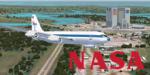

NASA-Vomit Comet Textures
(Category: FSX > Civil Jets)
8.80Mb (343 downloads)
The Weightless Wonder or more commonly known as the Vomit Comet. This is a repaint for Alejandro Rojas Lucena's FSX-SP2 Boeing 707-420 in NASA livery N931NA. You must have a copy of the B707 in order to work. Thanks Alejandro for allowing me to post.
Required files:
required file
Posted Sep 11, 2015 22:17 by David Robles
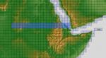
ASTER GDEMv2 30m mesh for Sudan & the Horn of Africa pt4
(Category: FSX > Terrain Mesh)
182.33Mb (343 downloads)
There are Eleven (11) parts of this mesh to download as separate files.
ASTER GDEM Version 2 is a 30 metre definition DEM, its better than the version 1 data that ERSDAC, of Japan and NASA originally released, but it does have its limitations.
GDEM has been obtained from a satellite that uses stereoscopic infrared scanning cameras, this brings with it problems in the resultant data.....where it sees the tops of trees, buildings etc, as the ground terrain.
If you look at the jpg image with the terrain type errors shown as a graph, you will see that the only 'safe' terrain to use this data with - in FSX - is scrubland, or desert terrain.
Its hopeless in defining the terrain in places like Europe - with all the artificial structures, (buildings) and different types of woodland, so any mesh I create from this data won't include areas like that....it will be more desert type terrain, and scrubland.
I won't be doing Greenland because something about the ice around Greenland, (or any other land mass with ice) it creates false data.
It does give enough fine data to reveal railway lines, and some roads though.
This mesh has been made for FSX only.
Grateful thanks to ERSDAC, and NASA for making this data freely available to the public.
ASTER GDEM
Copyright (c) 2009 - 2011 Earth Remote Sensing Data Analysis Center (ERSDAC) All rights reserved.
ASTER GDEM is a product of METI and NASA.
Posted Mar 17, 2012 08:52 by Wayne Evans
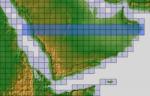
ASTER GDEMv2 30m mesh for Arabian Peninsula Pt4b
(Category: FSX > Terrain Mesh)
49.90Mb (343 downloads)
There are Twenty parts of this mesh to download as separate files.
ASTER GDEM Version 2 is a 30 metre definition DEM, its better than the version 1 data that ERSDAC, of Japan and NASA originally released, but it does have its limitations.
GDEM has been obtained from a satellite that uses stereoscopic infrared scanning cameras, this brings with it problems in the resultant data.....where it sees the tops of trees, buildings etc, as the ground terrain.
If you look at the jpg image with the terrain type errors shown as a graph, you will see that the only 'safe' terrain to use this data with - in FSX - is scrubland, or desert terrain.
Its hopeless in defining the terrain in places like Europe - with all the artificial structures, (buildings) and different types of woodland, so any mesh I create from this data won't include areas like that....it will be more desert type terrain, and scrubland.
I won't be doing Greenland because something about the ice around Greenland, (or any other land mass with ice) it creates false data.
It does give enough fine data to reveal railway lines, and some roads though.
This mesh has been made for FSX only.
Grateful thanks to ERSDAC, and NASA for making this data freely available to the public.
ASTER GDEM
Copyright (c) 2009 - 2011 Earth Remote Sensing Data Analysis Center (ERSDAC) All rights reserved.
ASTER GDEM is a product of METI and NASA.
Posted Mar 7, 2012 12:36 by Wayne Evans
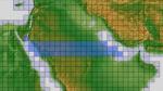
ASTER GDEMv2 30m mesh for Arabian Peninsula Pt2b
(Category: FSX > Terrain Mesh)
67.68Mb (343 downloads)
There are Twenty parts of this mesh to download as separate files.
ASTER GDEM Version 2 is a 30 metre definition DEM, its better than the version 1 data that ERSDAC, of Japan and NASA originally released, but it does have its limitations.
GDEM has been obtained from a satellite that uses stereoscopic infrared scanning cameras, this brings with it problems in the resultant data.....where it sees the tops of trees, buildings etc, as the ground terrain.
If you look at the jpg image with the terrain type errors shown as a graph, you will see that the only 'safe' terrain to use this data with - in FSX - is scrubland, or desert terrain.
Its hopeless in defining the terrain in places like Europe - with all the artificial structures, (buildings) and different types of woodland, so any mesh I create from this data won't include areas like that....it will be more desert type terrain, and scrubland.
I won't be doing Greenland because something about the ice around Greenland, (or any other land mass with ice) it creates false data.
It does give enough fine data to reveal railway lines, and some roads though.
This mesh has been made for FSX only.
Grateful thanks to ERSDAC, and NASA for making this data freely available to the public.
ASTER GDEM
Copyright (c) 2009 - 2011 Earth Remote Sensing Data Analysis Center (ERSDAC) All rights reserved.
ASTER GDEM is a product of METI and NASA.
Posted Mar 7, 2012 11:26 by Wayne Evans
CFS2 Carrier Mod: The Essex and the Enterprise: A Little More Room for Takeoff
(Category: CFS2 > Misc)
0.42Mb (343 downloads)
I personally think that the Grumman F6F, with Emergency War Power and full flaps ought to be able to carry more ordinance on carrier missions. Specs say it can carry 4000 pounds of ammunitions. With a drop tank, 8 rockets, and 2 1000 lbs bombs the total is under 3000 lbs weight. This should be more than doable for this plane configured correctly. So what I did here was move the start point back to 1 or 2 feet from the end of the fantail. This only effects the CV-6 and CV-9. On the CV-6 the F6F can carry the 500 lbs Bombs/Rockets and Droptank. On the CV-9 The F6F can carry the 1000's.
Posted Dec 18, 2011 07:05 by vincent farnham
PFD for FIP Patch
(Category: FS Gauges > FS Gauges)
0.00Mb (343 downloads)
PFD for FIP Patch. Correction for the PDF gauge for the FIP. I missed an information in installation instruction. In SaiFlightSimX.xml instruction, instead of File="pfdvge.xml" read File="Gauges\pfdvge.xml"
Posted May 25, 2011 03:42 by philippe verhaege
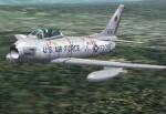

TR_F-86H 1st TFS, 413th TFW, 1957 Textures
(Category: CFS2 > Post WW2 Aircraft)
0.66Mb (343 downloads)
This is an original set of textures by Bub, AKA Bob McGee, representing an aircraft of the 1st TFS, 413th TFW, 1957.
Required files:
required file
Posted Jan 26, 2011 15:08 by Tom Sanford, Tango_Romeo
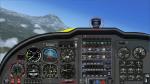
Legacy Widescreen Panel Update
(Category: FSX > Panels)
0.13Mb (343 downloads)
How to easily add 3 possibly missing gauges
Required files:
required file
Posted Nov 27, 2010 05:19 by Jean-Luc Peters