



All Time Popular > Page 4801


Default C172 Royal Blue Texture
(Category: FSX > Props)
34.07Mb (293 downloads)
This is my first repaint. It is for the default Cessna 172 SP Skyhawk. This is a complete aircraft folder that includes a white with royal blue trim texture for Skyhawks with the default steam gauge & Garmin G1000 panels.
Posted Apr 20, 2017 00:13 by David Shearer
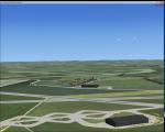
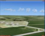
RAF Tarrant Rushton, UK, 1944
(Category: FSX > Scenery)
1.18Mb (293 downloads)
RAF Tarrant Rushton was a Royal Air Force station near the village of Tarrant Rushton east of Blandford Forum in Dorset, England from 1943 to 1947. It was used for glider operations during World War II and later revived for civilian operations. It is currently disused, though some buildings survive.
Horsa gliders from Tarrant Rushton left for France on the eve of D-Day, to begin Operation Tonga with an action that would later become known as Pegasus Bridge. Among the glider pilots was Jim Wallwork, on a Horsa nicknamed Lady Irene. The Tarrant Rushton gliders landed in occupied France shortly after midnight. Wallwork's aircraft was the first to touch down, but it landed heavily: the force of the impact catapulted both Wallwork and his co-pilot John Ainsworth through the front of the cockpit. Although stunned, this made them the first Allied troops to touch French soil on D-Day.
Other gliders were later flown from the airfield to Arnhem to take part in Operation Market Garden. During the closing stages of WWII, aircraft were used for SOE operations.
Posted Apr 22, 2016 10:45 by Terry Boissel

FS2004 Scenery-Russia-Mari El
(Category: FS2004 > Scenery)
2.29Mb (293 downloads)
FS2004 Scenery-Russia-Mari El
UWKC-Krasnogorka, UWKJ-Yoshkar-Ola (Pavlovo), XWKD-Yoshkar-Ola (Danilovo), ZA57-Kazin, ostrov, ZA5A-Khlebnikovo, ZA63-Kozikovo, ZA6T-Kuz'mino, ZA7Z-Mar'yino, ZA89-Mikryakovo, ZA9B-Novaya Sloboda, ZB01-Yurino, ZC6W-Toybekovo, ZC7X-Noviy Tor'yal, ZCJ2-Yurino-1, ZDS3-Shirokovo, ZE3F-Mari-Bilyamor, ZE3U-Kosolapovo, ZE45-Kuchka, ZE9W-Sernur, ZED9-Russkiy Kukmor, ZEE0-Ivanovka, ZEE1-Bol'shoy Vil'yal, ZEM2-Onuchino, ZEP7-Mit'kino, ZEP8-Kolyanur, ZEP9-Yuledur, ZEQ0-Mari-Turek, ZET2-Kuzhener, ZEV6-Yushkovo, ZEZ1-Elasy, ZF2Q-Nizhniy Rushener
Posted Dec 7, 2015 02:24 by Andrey Anta
RAF Melbourne, UK
(Category: FSX > Scenery)
0.03Mb (293 downloads)
RAF Melbourne was a Royal Air Force station typical of the expansion period of the Second World War. Located 5
miles to the South-west of Pocklington, Yorkshire, England. The nearest village is Seaton Ross.
East Common just outside the village of Seaton Ross was requisitioned for use as a grass airfield in November
1940. In late 1940 the airfield was used by Armstrong Whitworth Whitleys of 10 Squadron as a relief landing ground
for RAF Leeming. The airfield soon closed for re-development as a standard Bomber Command airfield with three
concrete runways and three hangars.
The first user of the re-built airfield was again 10 Squadron but by this time operating the Handley Page Halifax
four-engined heavy bomber, little time was wasted before the aircraft were used on operational sorties from
Melbourne. The squadron continued with operation until March 1945 and lost 109 aircraft on operations.
Melbourne was unusually equipped with FIDO fog dispersant system. This made the airfield popular diversion
airfield for other squadrons returning from operations to Yorkshire.
In May 1945 the airfield was transferred to RAF Transport Command and 575 Squadron moved in with the Douglas
Dakota. The squadron only stayed for a few months operating transport flight to and from continental Europe. With
the departure of the Dakota a number of specialised Flights used the airfield for six months but by the middle of
1946 the airfield was no longer used for flying.
Source: Wikipedia
Posted Dec 9, 2015 20:57 by Terry Boissel

Tuskegee Airmen Part 4
(Category: CFS2 > Missions & Campaigns)
125.49Mb (293 downloads)
Part IV of the Tuskegee Airmen campaign package! This is an effort to chronicle the flying history of the Tuskegee Airmen, who began their combat life as the 99th Fighter Squadron, and who later became the 332nd Fighter Group. Starting in April, 1943, this campaign package, split into four parts, covers one hundred and six missions from their beginning in April, 1943 to their end in May, 1945. The total length of the campaign is chopped into four smaller campaigns because of the limits of AI aircraft.
Within this package, you'll find the scenery folders, texture files, & GSL files needed for the campaign. The amount of files required necessitated this fourth package.
My absolute deepest gratitude to A. Talbot, and the aircraft builders, skin artists, scenery and weapons builders without whom this project could not have been completed.
Posted Nov 15, 2015 15:08 by Leland Lesher


Russia-Yaroslavl region airports
(Category: FS2004 > Scenery)
14.16Mb (293 downloads)
Russia-Yaroslavl region
HA2Q-Levashovo, UUBX-Yaroslavl' (Levtsovo), UUMJ-Breytovo, UUQA-Gavrilov Yam (Agat), XUDA-Karachikha, ZA1Q-Bolshevo, ZA3F-Fat'yanovo, ZA7M-Lyubim, ZA8V-Nikol'skoye, ZA9U-Oparino, ZAB5-Mel'nitsa, ZAE2-Poshekhon'ye, ZAQ4-Tatishchev Pogost, ZAW1-Protasyevo, ZB0N-Vasilyevo, ZBT1-Gologuzovo, ZCG1-Romanovo, ZDK2-Mar'yino, ZDK4-Karash, ZEA0-Votchitsevo, ZET5-Kalita
Posted Jun 5, 2015 14:49 by Andrey Anta
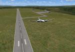
CHILE - Araucania
(Category: FSX > Scenery)
0.00Mb (293 downloads)
New Airport La Araucania Chile adds to V.12 Juan Lucero
Posted Mar 10, 2015 15:01 by Juan Lucero

Airbus A320-200 SAAF Textures
(Category: FSX > Civil Jets)
9.55Mb (293 downloads)
South African Air Force (SAAF) textures only for the Project Airbus A320-200 . This is a fictious livery. Textures by Jacques Louw.
Posted Aug 13, 2013 00:52 by Jacques Louw
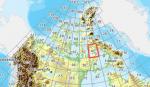
FSX Canadian CDED mesh above 60 degrees Lat 19 metre resolution Pt13, block 47.
(Category: FSX > Terrain Mesh)
116.41Mb (293 downloads)
As Raimondo Taburet hasn't processed the CDED files above 60 degrees latitude for Canada, well here are the ones I have processed.
There isn't any data available from geobase in some of the blocks above 60 degrees latitude, these are blocks: 15, 17, 18, 28, 108, 109, 118, 119.
See jpg for coverage.
Thanks go to Geobase (Copyright) Canada for the availability & public use of this data.
Posted May 17, 2012 03:39 by Wayne Evans
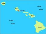
FSX Hawaii Airfield Locator
(Category: FS Navigation > Flight Simulator Navigation)
0.63Mb (293 downloads)
This download adds airfield markers and ICAO id's found in FSX, and overlays them on Google Earth.
This file is for Hawaii, USA.
There is also a separate file with a list of basic airfield location details.
i.e: EGBB Birmingham Airport. Birmingham. N52* 27.23' W1* 44.88' alt325
Other locator files to follow
by Carl Vokes
Posted Feb 5, 2012 14:37 by carl vokes