


All Time Popular > Page 4827
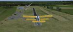
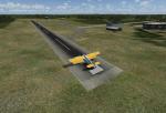
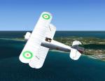
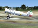
UK Farmstrips FTX 'L-P' Pack
(Category: FSX > Scenery)
125.26Mb (278 downloads)
UK Farmstrips FTX 'L-P' Pack.
Designed for use with ORBX FTX EU ENGLAND Scenery - probably works ok on default FSX to some degree. Base file and split into sections. 75 Farmstrips in all. List of fields:
X2LA Laindon,
X7LF Lane Farm,
X3LE Lark Engine,
X7LP Lleweni Parc,
X2LB Lower Botrea,
X2FK Lyminge,
X4LD Lymm Dam,
X2MR Manor Farm,
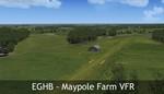
EGHB Maypole Farm,
X3CU Milson,
X7NC Nantclwyd,
X4NM North Moor,
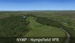
NYMP Nympsfield,
X2OH Old Hay,
X2OS Oldbury,
X2OG Orange Grove,
X4PT Pear Tree Farm,
X2PF Pent Farm.
INSTALL BASE FILE 1st.
Based on the work of:
UK Farmstrips by Gerry Winskill
Essex Airstrips 011 by Pete Chapman. Author: Palyarmerc.
Posted Apr 1, 2017 07:12 by admin
RAF Bodney, UK
(Category: FSX > Scenery)
1.18Mb (278 downloads)
Originally built as an RAF Bomber Command station the airfield was grass-surfaced and located on slightly rolling land with a hard surface perimeter track.
Initially it was used by aircraft of No. 21 Squadron RAF and No. 82 Squadron RAF (No. 2 Group) Bomber Command. They carried operations over France and later the Netherlands and even Norway. Their Bristol Blenheim IVs were joined on occasions by, in May 1941, 90 Squadron evaluating its new Boeing Fortress Mk 1s some Handley Page Hampdens for mining operations. 90 Squadron suffered heavy casualties and the use of the Fortress I was discontinued. Towards October 1942, the Blenheims were changed to Lockheed Venturas but the squadron moved on to RAF Methwold before the Venturas were operational.
RAF Bodney was transferred to the United States Army Air Forces in the summer of 1943. Placed under the jurisdiction of VIII Fighter Command of Eighth Air Force, it was primarily the home of the 352d Fighter Group, the "Blue Nosed Bastards of Bodney". The unit briefly moved to Belgium in January 1945 due to the Battle of the Bulge, although it returned in April. It was closed after the 352d returned to the United States in November.
Source: Wikipedia
Posted Jan 9, 2016 08:37 by Terry Boissel
RAF Metheringham, UK
(Category: FSX > Scenery)
0.02Mb (278 downloads)
Station Timeline
Squadron
Notes
October 1943 Station opened.
November 1943 No.106 Sqn Operating the Avro Lancaster. The squadron disbanded at the station on the 18th February
1946.
September 1944 No.1690 BDT Operating the Supermarine Spitfire, Hawker Hurricane, Miles Martinet. The Bomber
Defence Training Flight left Metheringham on the 4th June 1945.
June 1945 No.467 (RAAF) Sqn Operating the Avro Lancaster. The squadron disbanded at the station on the 30th
September 1945.
October 1945 No.189 Sqn Operating the Avro Lancaster. The squadron disbanded on the 20th November 1945.
March 1946 Station ceased flying and put on Care and Maintenance.
March 1946 No.93 MU The Maintenance Unit left Metheringham in December 1950.
1951 RAF Metheringham closed.
1961-2 The airfield is sold-off
Posted Dec 12, 2015 18:50 by Terry Boissel
Russia - Perm Region Airports
(Category: FS2004 > Scenery)
4.26Mb (278 downloads)
Russia-Perm Region Airports
H620-Bol. Sosnova, ZA7H-Perm' (Lugovskoye), ZB6O-Nizhneye Gorodishche, ZCB0-Myl'niki, ZCW2-Karazel'ga, ZE21-Aleksandrovsk
Posted Mar 18, 2015 13:09 by Andrey Anta
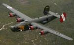
B-24J Textures
(Category: CFS1 > Aircraft)
0.06Mb (278 downloads)
This are B-24j Tweak Textures FOR DEFAULT CFS1 B-24j.
Posted Sep 17, 2013 22:11 by 64FULCRUMFREAK

FSX Oil Rig Locator Update 3
(Category: FS Navigation > Flight Simulator Navigation)
4.08Mb (278 downloads)
This update adds the instructions for installing the oilrig icon to Google Earth.
Icon courtesy of NDBC Observation (Google Earth)
This update replaces FSX_oil_rig_locator_update_2.
It adds the 'Google image store file' that l forgot to include in the last update.
Now the "oil rig icon" install instructions should make more sense.
I am dreadfully sorry for the oversight.
Tested on Windows XP and Windows 7.
This download adds markers for the oil rigs found in FSX, and overlays them on Google Earth.
If they have them, it also gives, name, ADF and DME freq.
Also the tidying "My places" in Google Earth, file.
Other locator files to follow.
by Carl Vokes
Posted Mar 11, 2013 21:43 by carl vokes
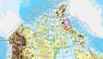
FSX Canadian CDED mesh above 60 degrees Lat 19 metre resolution Pt9, block 38.
(Category: FSX > Terrain Mesh)
41.32Mb (278 downloads)
As Raimondo Taburet hasn't processed the CDED files above 60 degrees latitude for Canada, well here are the ones I have processed.
There isn't any data available from geobase in some of the blocks above 60 degrees latitude, these are blocks: 15, 17, 18, 28, 108, 109, 118, 119.
See jpg for coverage.
Thanks go to Geobase (Copyright) Canada for the availability & public use of this data.
Posted May 16, 2012 15:37 by Wayne Evans
AF Scrub Persian Fury
(Category: CFS2 > Aircraft)
2.27Mb (278 downloads)
With this beauty we close the Furies Series.
Posted Apr 2, 2012 08:05 by Pepe Rezende
VRS Superbug VX-23 Updated CAG Textures
(Category: FSX > Payware)
2.34Mb (278 downloads)
VRS Superbug VX-23 Salty Dogs updated CAG
textures Requires the Payware VRS Superbug
enjoy repaint by Hornet202
Posted Jul 28, 2011 15:14 by Chris Hammons
MTO_NAG r13_August 15th 1944
(Category: CFS3 > Missions & Campaigns)
0.01Mb (278 downloads)
For ETO V1.40 or higher. First of all, thanks to Bob 'rbp71854' who has made the mission template and gave me permission to use it. He has done 99% of the boring job and without him, this mission would never have been the same and so immersive.
Overview:
2./NAGr 13, Cuers, august 15th 1944. Alarm, ALARM!! Allies have initiated an amphibious and airborne assault in southern France, HQ requires informations immediately to prepare a counterattack. Confusion is complete, report where the major landings operations are and try to determine where is the airborne assult by spotting gliders on ground. This is a high priority mission....
Posted Dec 11, 2010 14:02 by Led Zeppelin