


All Time Popular > Page 4831
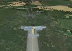
RAF Little Rissington, UK
(Category: FSX > Scenery)
0.02Mb (277 downloads)
RAF Little Rissington (ICAO: EGVL) is an RAF aerodrome and former RAF station in Gloucestershire, England. It was once home to the Central Flying School, the Vintage Pair and the Red Arrows.
Built during the 1930s, the station was opened in 1938 and closed in 1994. The married-quarters and main technical site were sold in 1996 (the former becoming the village of Upper Rissington), but the aerodrome has been retained by the Ministry of Defence and remains active along with the southern technical sites, under the operational control of HQ No.2 Flying Training School at RAF Syerston.
It is now home to 637 Volunteer Gliding Squadron as the primary military unit, who provide elementary flying training for Combined Cadet Force and Air Training Corps cadets. The airfield is also used by the forces as a relief landing ground, training area and parachute dropping area. In previous years, the Royal Air Force estate has been used as a film set, including The Avengers, part of the ice chase in Die Another Day, and the Thunderbirds film
Souce: Wikipedia
Posted Dec 6, 2015 08:25 by Terry Boissel
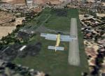
RAF Dunholme Lodge, UK
(Category: FSX > Scenery)
0.01Mb (277 downloads)
RAF Dunholme Lodge was a Royal Air Force station located between the parishes of Welton and Dunholme in
Lincolnshire, England.
The grass airfield was first used by the Royal Air Force during 1941 and 1942 for use by Handley Page Hampden
aircraft from nearby RAF Scampton, and was officially opened as a RAF Station in September 1942 as part of RAF
Bomber Command with the building of three hard runways.
The main occupier of the station was 44 Squadron, with the Avro Lancaster four-engined heavy bomber, which moved
in from RAF Waddington in May 1943 and stayed until it moved to RAF Spilsby in September 1944.
In November 1944 flying operations ceased due the proximity of other stations which did not allow night flying. At
the end of the war 120 Lancasters had been lost on operations from Dunholme Lodge.
From 1948 the site was host to motorcycle and car racing until 1959 when the base was reopened as an active RAF
station when it became an active Bloodhound surface-to-air missile station with 141 Squadron.The Squardron in 1964
and the station finally closed in 1964.
Source Wikipedia
Posted Dec 6, 2015 06:18 by Terry Boissel
Russia-Oryol region airports
(Category: FS2004 > Scenery)
19.58Mb (277 downloads)
FS2004 Scenery-Russia-Oryol region
UUOR-Orel (Yuzhniy), XUOE-Orel (Pugachevka), ZA9V-Orel (Severniy), ZAN7-Stal'noi Kon', ZAR9-Topki, ZC3H-Dobry, ZC3J-Boytsovskiy, ZC53-Lavrovo, ZC64-Nikol'skoye, ZC6X-Pen'shino, ZC6Y-Navesnoye, ZC70-Kromy, ZC71-Verkhov'ye, ZC72-Znamenskoye, ZC73-Shablykino, ZC75-Taldykino, ZE1E-Dolgoye, ZE3P-Khvorostyanka, ZE3Q-Bolkhov, ZE3R-Bunino, ZE3T-Kolpny, ZE99-Livny, ZE9A-Pokrovskoye, ZEE9-Glebovo, ZEF0-Podbelevets, ZEF1-Dubovaya Roshcha, ZEK9-Lyubanovo
Posted Sep 15, 2015 16:55 by Andrey Anta
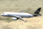
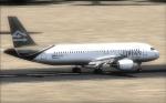
SMS A320 CFM Libyan Textures
(Category: FSX > Payware)
7.17Mb (277 downloads)
Libyan Airlines Airbus A320 repaint, for Overland SMS Airbus A320 CFM model. Textures only.
Posted Jun 21, 2015 03:39 by Dimitrios Moschos
Graf Ignatievo Air Force Base LBPG Bulgaria
(Category: FSX > Scenery)
3.99Mb (277 downloads)
Graf Ignatievo AFB does not exist in FSX and also the on the some navcharts. Note that the real NAVAIDS frequencies could be different from those presented in the scenery. Read the notifications enclosed.
Posted Aug 1, 2013 13:12 by Sergey Stoyanov
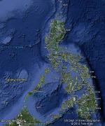
FSX Philippines Airfield Locator
(Category: FS Navigation > Flight Simulator Navigation)
2.67Mb (277 downloads)
Tested on Windows XP and Windows 7.
This download adds airfield markers and ICAO id's found in FSX, and overlays them on Google Earth.
This file is for the Philippines.
There is also a seperate file with a list of basic airfield location details.
i.e: EGBB Birmingham Airport. Birmingham. N52* 27.23' W1* 44.88' alt325.
Also the tidying "My places" in Google Earth, file.
Other locator files to follow.
by Carl Vokes
Posted Sep 7, 2012 14:34 by carl vokes
Vindicator British Aircraft Update
(Category: CFS3 > Aircraft)
0.01Mb (277 downloads)
Updated xdp files for the two Britsh versions of the Vindicator. Corrects entered and left service dates.
Required files:
required file
Posted Jul 5, 2012 22:35 by Rob stevenson (Capt. Winters)
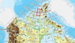
SX Canadian CDED mesh above 60 degrees Lat 19 metre resolution Pt25, block 69.
(Category: FSX > Terrain Mesh)
45.92Mb (277 downloads)
As Raimondo Taburet hasn't processed the CDED files above 60 degrees latitude for Canada, well here are the ones I have processed.
There isn't any data available from geobase in some of the blocks above 60 degrees latitude, these are blocks: 15, 17, 18, 28, 108, 109, 118, 119.
See jpg for coverage.
Thanks go to Geobase (Copyright) Canada for the availability & public use of this data.
Posted May 17, 2012 12:37 by Wayne Evans
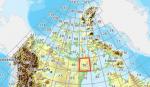
FSX Canadian CDED mesh above 60 degrees Lat 19 metre resolution Pt17, block 56.
(Category: FSX > Terrain Mesh)
159.31Mb (277 downloads)
As Raimondo Taburet hasn't processed the CDED files above 60 degrees latitude for Canada, well here are the ones I have processed.
There isn't any data available from geobase in some of the blocks above 60 degrees latitude, these are blocks: 15, 17, 18, 28, 108, 109, 118, 119.
See jpg for coverage.
Thanks go to Geobase (Copyright) Canada for the availability & public use of this data.
Posted May 17, 2012 09:41 by Wayne Evans
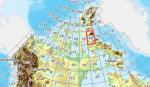
FSX Canadian CDED mesh above 60 degrees Lat 19 metre resolution Pt14, block 48.
(Category: FSX > Terrain Mesh)
123.77Mb (277 downloads)
As Raimondo Taburet hasn't processed the CDED files above 60 degrees latitude for Canada, well here are the ones I have processed.
There isn't any data available from geobase in some of the blocks above 60 degrees latitude, these are blocks: 15, 17, 18, 28, 108, 109, 118, 119.
See jpg for coverage.
Thanks go to Geobase (Copyright) Canada for the availability & public use of this data.
Posted May 17, 2012 04:44 by Wayne Evans