



All Time Popular > Page 5446

Parry Sound CNK4
(Category: Prepar3d > Scenery)
9.08Mb (98 downloads)
Parry Sound CNK4 scenery for Prepar3D. This is a self-contained scenery package for enhancing the Parry Sound CNK4 appearance. The native CNK4 is rather poor, but the real Parry Sound is a fairly busy airport, located in the Ontario "Cottage Country" only a few kilometres from the town of Parry Sound, on Lake Huron. Please note that P3D's terrain is full of towns and farms that don't exist, including in the area of this airport, but I didn't do anything about it. The package is simple to install, just unzip and locate the folder somewhere convenient, then "add" it to the scenery library. If you have problems installing, send me an e-mail. All objects are created with gmax. You can do anything you want to it, so as long as you don't sell my objects, in whole or in part. If you need any of the gmax files, just send me an e-mail. My e-mail address is in the zip. Made by Fern Marques, static aircraft by Dave P. March 2017. Thanks.
Posted Mar 4, 2017 12:31 by Fern Marques
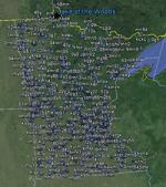
FSX Minnesota Airfield Locator
(Category: FS Navigation > Flight Simulator Navigation)
2.55Mb (98 downloads)
Tested on Windows XP and Windows 7.
This download adds airfield markers and ICAO id's found in FSX, and overlays them on Google Earth.
This file is for Minnesota.USA.
There is also a seperate file with a list of basic airfield location details.
i.e: EGBB Birmingham Airport. Birmingham. N52* 27.23' W1* 44.88' alt325.
Also the tidying "My places" in Google Earth, file.
Other locator files to follow.
by Carl Vokes
Posted Jul 15, 2013 10:29 by carl vokes

FSX Micronesia Airfield Locator
(Category: FS Navigation > Flight Simulator Navigation)
2.43Mb (98 downloads)
Tested on Windows XP and Windows 7.
This download adds airfield markers and ICAO id's found in FSX, and overlays them on Google Earth.
This file is for Micronesia.
There is also a seperate file with a list of basic airfield location details.
i.e: EGBB Birmingham Airport. Birmingham. N52* 27.23' W1* 44.88' alt325.
Also the tidying "My places" in Google Earth, file.
Other locator files to follow.
by Carl Vokes
Posted Apr 22, 2013 12:20 by carl vokes

FSX Louisiana Airfield Locator
(Category: FS Navigation > Flight Simulator Navigation)
2.56Mb (98 downloads)
Tested on Windows XP and Windows 7.
This download adds airfield markers and ICAO id's found in FSX, and overlays them on Google Earth.
This file is for Louisiana.USA.
There is also a seperate file with a list of basic airfield location details.
i.e: EGBB Birmingham Airport. Birmingham. N52* 27.23' W1* 44.88' alt325.
Also the tidying "My places" in Google Earth, file.
Other locator files to follow.
by Carl Vokes
Posted Feb 17, 2013 12:18 by carl vokes

FSX Estonia Airfield Locator
(Category: FS Navigation > Flight Simulator Navigation)
2.56Mb (98 downloads)
Tested on Windows XP and Windows 7.
This download adds airfield markers and ICAO id's found in FSX, and overlays them on Google Earth.
This file is for Estonia.
There is also a seperate file with a list of basic airfield location details.
i.e: EGBB Birmingham Airport. Birmingham. N52* 27.23' W1* 44.88' alt325.
Also the tidying "My places" in Google Earth, file.
Other locator files to follow.
by Carl Vokes
Posted Nov 1, 2012 15:22 by carl vokes

Justflight Duchess Black and Red Textures
(Category: FSX > Payware)
3.54Mb (98 downloads)
Textures only for the payware Justflight Beechcraft Duchess in Black colors with red stripes. Enjoy and Happy flying!
Posted Aug 18, 2012 00:57 by Lloyd Horton

7.80Mb (98 downloads)
Air Zermat Icaro EC-135 textures for the freeware FS2004 Icaro EC-135.
Required files:
required file
Posted Nov 9, 2011 11:14 by benimix - Benedikt Fröhlich

FS2004 Flight Plan for OB-96 Fort Worth Texas
(Category: FS Navigation > Flight Simulator Navigation)
0.46Mb (98 downloads)
FS2004 Flight Plan for OB-96 Fort Worth Texas IFR high speed low altitude military training route. This is the fifteenth in a series of FS2004 flight plans I have uploaded. This route goes through mostly flat and rolling terrain in Texas, Oklahoma and Louisiana. This route has two different sets of targets. These are great routes for B-52, F-111, B-1B, B-2 A6, A4, Vulcan and any fighter or bomber enthusiasts. Of course you can fly the route with any aircraft of your choice. Included in this package is a gauge by Karol Chlebowski for TFR flying at very low altitude. This gauge will greatly enhance your ability to fly these challenging routes and is a great companion of the flight plans. Another option to download Version 2.0 of my FS2004 mini panel which has all this functionality and more.
Posted Jul 27, 2011 22:32 by Bill McClellan

FS2002/2004 Geneve, Switzerland Soaring Scenery
(Category: FS2004 > Gliders and Ultralites)
0.07Mb (98 downloads)
FS2002/2004
Geneve, Switzerland Soaring Scenery
This file add some thermals to default Microsoft scenery for
Geneve(LSGG),Switzerland: By Francisco Vargas. 68K
Posted Jun 23, 2008 14:18 by archive

Pilatus
PC-12
(Category: FS98 > Panels)
(98 downloads)
Pilatus
PC-12, Photorealistic. File size1853493. V Leightower
Posted Jun 23, 2008 14:21 by archive