


All Files > Page 1664
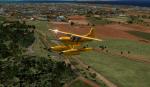
The Curse of the Temples
(Category: FSX > Missions)
12.86Mb (2075 downloads)
This is not a Mission!!!...A first time in FSX it is!!!!!. First you will Listen to instructions, then you will --Read a Short Story about the Adventure Max Rex got into by following a beautiful woman in an expedition to Burma back in the 1930s.--In it you will find the routes they took and you get a map to plot them--then and only then will you find the mysterious Temples and the final outcome of the expedition....I hope you enjoy the story and the flights...For experienced bush pilots only.
Posted Jul 5, 2012 23:27 by Gera Godoy Canova
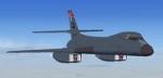
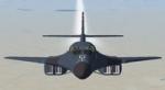
Views for the Alphasim B-1B Lancer Package
(Category: FSX > Military)
0.10Mb (3313 downloads)
2 set of views ( defined by camera definitions in the aircraft.cfg file )
for the beautiful Rockwell B-1B Lancer by Alpha Simulations (
now Virtavia ). First set is my usual views ( same level ).
Second set places cameras at a higher level.
Up to 11 cameras pointing at the aircraft, total of 4 views in the virtual cockpit.
See Read me.txt file for very easy installation procedures.
And finally two more files - Available.pdf and Top 20.pdf for informations
about my "camera definitions" packages.
Required files:
required file
Posted Jul 5, 2012 23:24 by Marc Renaud
Vindicator British Aircraft Update
(Category: CFS3 > Aircraft)
0.01Mb (279 downloads)
Updated xdp files for the two Britsh versions of the Vindicator. Corrects entered and left service dates.
Required files:
required file
Posted Jul 5, 2012 22:35 by Rob stevenson (Capt. Winters)
Vindicator French Aircraft Update
(Category: CFS3 > Aircraft)
0.36Mb (245 downloads)
One missing texture and two updated xdp files for French versions. see readme for instructions.
Required files:
required file
Posted Jul 5, 2012 21:17 by Rob Stevenson (Capt. Winters)
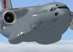

Area51 C-17 ZZ177 "Red 10" Tail Textures
(Category: FS2004 > Payware)
5.60Mb (1792 downloads)
FS2004 Repaint for the payware Area51 simulations C-17 Globemaster, depicting ZZ177 of 99 Squadron RAF as it appeared at many airshows through 2011.
Texture by Gary J. Scott
Posted Jul 5, 2012 20:12 by Gary J. Scott
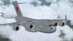

Area51 C-17 ZZ177 "Red 10" Tail Textures
(Category: FSX > Payware)
4.99Mb (1844 downloads)
Repaint for the Area51 simulations C-17 Globemaster, depicting ZZ177 of 99 Squadron RAF as it appeared at many airshows through 2011.
Texture by Gary J. Scott.
FSX Conversion by my friend Andy Nott (AGN Textures).
Posted Jul 5, 2012 20:06 by Gary J. Scott
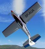
FS2004 Zlin Z-50L
(Category: FS2004 > Props)
0.59Mb (1290 downloads)
FS2004 Zlin Z-50L
By Peter,Piotr Sabadasz.
Fixed prop and FD
by George Csillag
Posted Jul 5, 2012 17:44 by George Csillag
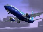
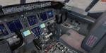
Boeing 737-900 Multi Package (with tail View)
(Category: FSX > Civil Jets)
107.60Mb (16675 downloads)
FSX Boeing 737-900 Mutli livery package - with comprehensive Alejandro Rojas Lucena/FSND VC. Liveries: Continental, Boeing Dreamliner, Alaska, KLM, Factory unpainted, Posky. This model includes Working wipers (right mouse click on switch)
with rain effect. Switches for LCD Screens, EICAS, PFD, MFT.
Autobrake switch. Opening pilots window. Cabin Lights switch.
Realistic FMC. Ground Proximity Warning System (GPWS), More
Realistic night textures. Model features High resolution textures,
Dynamic flexing wings, Body gear steering, Nose gear steering,
Rudder lock, Ground spoilers, Low speed aileron locks at high speed,
Fully animated control surfaces, Fully independent suspension, Trim
Animation, Opening Passenger Doors, Animated tilting bogies, Rolling
wheels, Animated thrust reverser's with reverser block doors,
Detailed textures, Full night lighting, Crash affects, Ground
Service Vehicles And more. Model Designer Hiroshi Igami. Flight
Dynamics Designer Warren C. Daniel. Reworked with a tail view!
Posted Jul 4, 2012 23:12 by Peter D
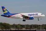
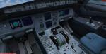
Spirit Airlines Airbus A320 Package
(Category: FSX > Civil Jets)
59.03Mb (6500 downloads)
Spirit Airlines Airbus A320-200. Project Airbus A320 model with added A321 VC and custom Airbus sounds.
Posted Jul 4, 2012 23:06 by Peter D
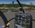
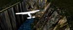
Hana Heli-Training Obstacle Course v3.0
(Category: FS2004 > Scenery)
91.91Mb (901 downloads)
Hana Airport is a regional airport of the State of Hawaii on the east shore of the island of Maui, 3 NM northwest of the unincorporated town of Hana. The airport covers 119 acres and has one runway. It is primarily a commuter facility used by unscheduled air taxis and general aviation. This scenery is intended as a single / multiplayer helicopter obstacle course where heli pilots can meet to compete, show off, and share their helo skills. Since birdseye (Timm Turner) already did a neat scenery called Hana_Scenery_PHHN (see link below), we decided (with Timm's permission) to convert PHHN to a full helicopter training area.
Makes a great place for helo pilots to gather and to practice their perfect skills, and other pilots challenge! Keep an eye-out for Hot Air Balloon that's cruising around an altitude of 3000 feet (don't forget to wave at them! .) Another unique thing about this scenery is the neighboring islands (Honolulu Intl, Hickam AFB, Bellows AFB, Lanai City, Kahului, Molokai, etc). If you get frustrated during your heli obstacle course training, just take a heading of 275 degrees, and relax at one of the neighboring islands. We also added an Easter Egg - If you set your FS calendar to July 21st, you'll see a large ridge fire up in the hills. Load Jordan Moore's Erickson S64E ( http://www.hovercontrol.com/) & try your skills at water bombing!
Posted Jul 4, 2012 21:27 by Bob Ferguson