


All Files > Page 1668
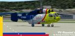
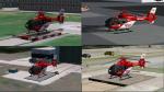
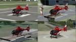
AlphasimKa-32 Heliswiss LZ-KBH Textures
(Category: FS2004 > Payware)
3.14Mb (440 downloads)
Ka-32 Heliswiss LZ-KBH s for the payware Alphasim Fs2004/FsX KA32. Texture by Jose Armando Yanez YV-Repaint's
Posted Jun 29, 2012 11:39 by Jose Armando Yanez
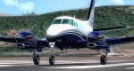
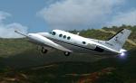
Carendo King C90 Private textures
(Category: FSX > Payware)
24.92Mb (657 downloads)
Private textures for the payware Carendo King C90 in Venezuela Reg. YV-374CP. Textures only.
Posted Jun 29, 2012 11:30 by Trino Jose Rojas Mora
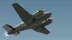
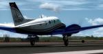
Carendo King C90 ARBV-0201 Textures
(Category: FSX > Payware)
29.17Mb (249 downloads)
FSX Armada Bolivinara Venezuela textures for the payware Carendo King C90
Posted Jun 29, 2012 11:13 by Trino Jose Rojas Mora
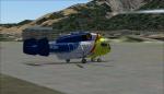
DRF Texture Pack for ICARO EC-135 Package
(Category: FS2004 > Helicopters)
89.80Mb (860 downloads)
DRF (German Air rescue) texture pack for the Icaro EC-135 package. Included: Christoph 11, 27, 36,37, 38, 41, 43, 44, 45, 46, 49, 53, 60, 80 Current identifiers June 2012. Icaro EC-135 base pack required.
Required files:
required file
Posted Jun 28, 2012 21:05 by benimix - Benedikt Fröhlich
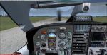
FSX Acceleration TBM 700 VC Texture Update
(Category: FSX > Props)
4.27Mb (2718 downloads)
These textures fix the glass and VC rain for FSX Acceleration in the TBM 700 from the French Design team lead by Michel Migaud and Cyril Breton and available on simviation. The VC rain textures will work for other FS9 imported aircraft that blue out when it rains.
Required files:
required file
Posted Jun 28, 2012 14:37 by John Hauck
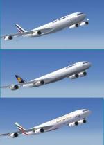
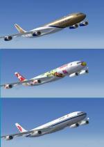
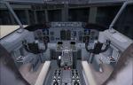
Airbus A340 3-5-6 Mega Package
(Category: FSX > Civil Jets)
191.94Mb (34624 downloads)
Tom Ruth A340-300, -500 , -600 Airbus A340 mega package including multiple airlines, with added FMC, altitude callouts, autoland. Liveries include: Airbus Industrie, Lufthansa, Air France, Hainan, Air China, China Southern, China Eastern, TAP, Virgin, KLM, Sabena, SAA Star Alliance, SAA, Thai, Swiss, Qatar (old and new), Iberia, Emirates, Cathay, Turkish, Eva Air, Arik Air, TAM, Etihad, Gulf, Finnair. See files for credits. Bry Hardee altitude call outs - Garrett Smith FMC - AutoLand. Original models and VC's by Thomas Ruth.
Posted Jun 28, 2012 10:25 by T.Marson
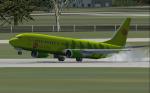
Boeing 737-465 Siberia S7 Airlines Package
(Category: FSX > Civil Jets)
18.02Mb (4670 downloads)
In the first half of the 1990s, Siberia Airlines was a medium-sized regional airline, like many others created from former Aeroflot divisions. Operations were mainly focused on domestic flights from Novosibirsk. By the end of the decade, however, the airline started an aggressive expansion plan in the Russian domestic market.
Model FS2004 default updated for FSX. (inc. VC) Textures by ricardo_tv.
Posted Jun 28, 2012 08:38 by ricardo_tv
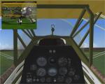
Spike's P6-E Hawk with Engine Fire Effects
(Category: FS2004 > Vintage)
27.81Mb (1039 downloads)
P6-E Hawk with added engine flames by spike 2012.
Other mods include: gyro sound, prop dust, engine smoke, engine flames, extra switches (lights, fuel pump and carb heat) and fixed ignition switches.
Prop and wheel dust by Nick. Original model by A.F.Scrub.
Posted Jun 28, 2012 03:57 by Spike
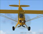
Spike's Piper J-3 Cub with Engine Fire Effects
(Category: FSX > Props)
7.44Mb (1718 downloads)
Spike's Piper J-3 Cub with Engine Fire Effects. Original Piper cub by Microsoft.
Texture fix by Tony Gould.
Updated with Spike's EngineFire and exhaust FX 2012.
Posted Jun 28, 2012 01:59 by Spike
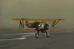
Spike's Stampe SV4 with Engine Fire Effects
(Category: FS2004 > Vintage)
4.21Mb (975 downloads)
Eric Dante's Stampe SV4 updated with Spike's Engine Fire and exhaust FX 2012 effects.
Posted Jun 28, 2012 01:23 by Spike