


All Files > Page 1686
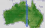
ASTER GDEMv2 30m mesh for Australia Pt9
(Category: FSX > Terrain Mesh)
161.76Mb (411 downloads)
There are Nineteen (19) parts to download for GDEMv2 of Australia.
ASTER GDEM Version 2 is a 30 metre definition DEM, its better than the version 1 data that ERSDAC, of Japan and NASA originally released, but it does have its limitations.
GDEM has been obtained from a satellite that uses stereoscopic infrared scanning cameras, this brings with it problems in the resultant data.....where it sees the tops of trees, buildings etc, as the ground terrain.
If you look at the jpg image with the terrain type errors shown as a graph, you will see that the only 'safe' terrain to use this data with - in FSX - is scrubland, or desert terrain.
Its hopeless in defining the terrain in places like Europe - with all the artificial structures, (buildings) and different types of woodland, so any mesh I create from this data won't include areas like that....it will be more desert type terrain, and scrubland.
I won't be doing Greenland because something about the ice around Greenland, (or any other land mass with ice) it creates false data.
It does give enough fine data to reveal railway lines, and some roads though.
This mesh has been made for FSX only.
Grateful thanks to ERSDAC, and NASA for making this data freely available to the public.
ASTER GDEM
Copyright (c) 2009 - 2011 Earth Remote Sensing Data Analysis Center (ERSDAC) All rights reserved.
ASTER GDEM is a product of METI and NASA.
Posted Jun 2, 2012 02:58 by Wayne Evans
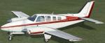
FSX default Beech B58 Baron Tire Fix
(Category: FSX > Props)
1.59Mb (616 downloads)
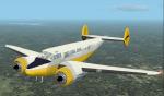
All of my FSX default Beech B58 Barons have always worked fine
except for one. The white one with red stripes (as shown in
the enclosed screenshot) has always had black tires while standing
still on the ground, then the tires change to completely white while
rolling on the ground, then they change back to their proper black once
airborn. If this also happens to you while flying your white and red
striped default Baron, this fix may work for you. Easy installation.
By Tom Tiedman
Posted Jun 1, 2012 18:58 by Tom Tiedman
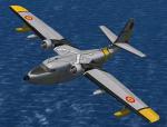
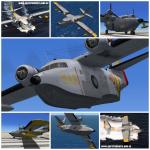
FSX SAR Textures only for the Virtavia (Alphasim) HU-16 Albatross
(Category: FSX > Payware)
1.81Mb (431 downloads)
This represents an aircraft assigned to Spanish Air Rescue's Service (SAR: Servicio Aéreo de Rescate), a part of spanish Air Army. Textures only for the payware Aphasim HU-16 Albatross.
Posted Jun 1, 2012 16:48 by Enrique Medal
FS2002/2004 Beech C45 Aloha Air
(Category: FS2004 > Props)
15.96Mb (1307 downloads)
The Beechcraft Expeditor done up in two liveries: a tourist airline, and a private owner scheme. Also included are a set of blank textures for your own repaints. Original Aircraft by F. Giuli, sound package by Chuck Dome and other sources, repaints by Don Brynelsen.
Posted Jun 1, 2012 13:15 by Don Brynelsen
737-800 Black Panel Gauge Updated
(Category: FSX > Panels)
2.85Mb (5551 downloads)
Changes the default blue of the B737-800 gauges to black. Fixes the backup ADf-VOR and changes the Autopilot and speed brake light colours,(reasons for change in colour back to green = the red lights that were created, didn't fit the Panel correctly) same with speed brake
Posted Jun 1, 2012 12:13 by Fabian Irimiea
Durban International Airport, Sth Africa
(Category: FSX > Scenery)
0.02Mb (554 downloads)
FADN Durban, Sth Africa airport upgrade. By Michael Adkin.
Posted Jun 1, 2012 10:43 by Michael Adkin
Cape Town International Airport, Sth Africa
(Category: FSX > Scenery)
0.02Mb (1300 downloads)
Cape Town International Airport in South Africa upgraded to include more real details. By Michael Adkin.
Posted Jun 1, 2012 10:41 by Michael Adkin

Boeing 777-200LR Delta Airlines
(Category: FS2004 > Civil Jets)
21.12Mb (4886 downloads)
Boeing 777-200LR Delta Airlines. Model by Project Opensky.
Posted Jun 1, 2012 09:24 by uploader
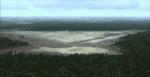
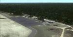
Mackall Army Airfield, NC, Photo Scenery
(Category: FSX > Scenery)
73.06Mb (1161 downloads)
Mackall Army Airfield, NC. Camp Mackall is an active U.S. Army training facility located in eastern Richmond County and northern Scotland County, North Carolina, south of the town of Southern Pines. The facility is in close proximity to and is a sub-installation of Fort Bragg (home to the XVIII Airborne Corps, the 82nd Airborne Division and the U.S. Army Special Operations Command Headquarters).
Scenery Description
This scenery includes the following:
- Mackall Army Airfield (KHFF)
o Custom models and textures for airport objects
o High-detail ground poly
o High resolution satellite imagery color corrected for seasonal changes
o Water and blend mask on the imagery for a perfect blend into the area
o The Airport Guys’ “TrueGlow” custom lighting effects
o Army base at Camp Mackall
o Taxiway signage
o Runway 11-29 is now open to reflect the repaving done in late 2011
o No frame rate impact
- Luzon Drop Zone
o Dirt landing strip approximately 1 NM southeast of Mackall AAF
o High resolution satellite imagery for the Luzon DZ
o Used for Army “Care Package” training drops. By The Airport Guys
Posted Jun 1, 2012 06:50 by uploader
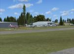
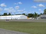
Potomac Airfield (KVKX), Maryland
(Category: FSX > Scenery)
30.44Mb (800 downloads)
FSX Potomac Airfield (KVKX), also known as Potomac Airport or Potomac Airpark, is a privately-owned, public-use airport located in the community of Fort Washington, Maryland (MD), just outside of Washington, D.C. Along with College Park Airport and Washington Executive Airport/Hyde Field, it is located in the Flight Restricted Zone (FRZ) in the center of the Washington, D.C. Air Defense Identification Zone. Pilots are required to apply for a special security clearance before they are permitted to fly into these airports. Potomac Airfield is also home to Buckley Aviation where you can learn aerobatics. By Christopher G. Clawson.
Posted Jun 1, 2012 06:29 by uploader