


All Files > Page 1691
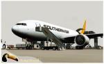
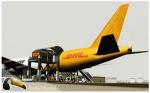
Boeing 777-200LRF Southern Air/DHL
(Category: FS2004 > Civil Jets)
19.47Mb (3403 downloads)
Project Opensky Boeing 777-200LRF Southern Air/DHL Cargo. In early 2011, Southern Air entered into a multiple year contract with DHL Aviation; by utilizing the 777's fuel efficiencies, long range and cargo capabilities, SAI was able to augment DHL's overnight express package delivery service through hubs in Cincinnati, Bahrain, Hong Kong and Anchorage, increasing package delivery options provided by DHL to its customers.
Posted May 27, 2012 03:51 by uploader
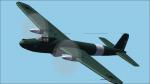
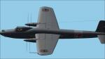
F Giulli MB902
(Category: CFS2 > Aircraft)
22.21Mb (391 downloads)
An extremely unorthodox design, the all-metal MB.902 mounted two 1475 h.p. FIAT R.A.I050 R.C.58 Tifone (license-built DB 605A) twelve-cylinder vee engines buried in the fuselage and driving twin contra-rotating airscrews in the wings by extension shafts.
Posted May 27, 2012 02:37 by Pepe Rezende
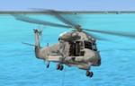
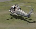
Views for the Kaman SH-2G Seasprite
(Category: FSX > Helicopters)
0.10Mb (1697 downloads)
Views ( defined by camera definitions in the aircraft.cfg file )
for the beautiful Kaman SH-2G Seasprite. Original model by Adrian Brausch & Nigel Booth.
VC modified by MaDRich.
8 cameras pointing at the aircraft and a total of 5 views in the 3D cockpit.
See Read me.txt file for very easy installation procedures.
One camera definitions.txt file for all models
And finally two more files - Available.pdf and Top 20.pdf for informations
about my "camera definitions" packages.
Required files:
required file
Posted May 27, 2012 02:21 by Marc Renaud
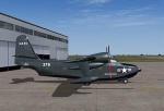
Grumman HU-16 Albatross Package 2.1.
(Category: FS2004 > Props)
88.10Mb (5244 downloads)
Grumman HU-16 Albatross Package 2.1.
The flight model is the most significant change. The flight model has been enhanced by the use of Jerry Beckwith's AirWrench.
The performance of the Albatross is now much closer to the parameters published for it. I've also adjusted the contact points for the hull. Includes VC and 2d panel.
Please make sure you adjust the fuel and payload before flying. This is a very heavy aircraft, and will be very sluggish if you attempt flight wtih full tanks and a full payload.
I've also added a few liveries, and modified several others. The colors and lettering of the U.S. Navy versions have been revised. The font the Navy uses is USN Long Beach. The paint colors are accurate now as well. You will also find new spin prop textures.
I've also slightly revised the original U.S. Air Force HU-16B and two of the U.S. Coast Guard liveries.
New for this release: U.S. Navy VXE6 UF-1L triphibian that served in the Antarctic, Chalk's G-111 and two new private liveries.
Greg Pepper, Michael Verlin.
Posted May 27, 2012 01:08 by uploader
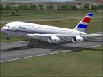
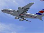
Lacsa Costa Rica Airbus A380
(Category: FS2004 > Civil Jets)
1.95Mb (3285 downloads)
Lacsa livery on the Robert Versluys
Airbus A380.
Lacsa 80s version.
Posted May 26, 2012 23:29 by Alberto Thomas
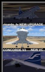
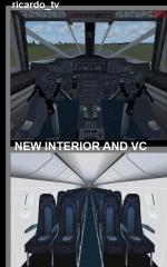
FSX PM2 Concorde Redux Package
(Category: FSX > Civil Jets)
139.53Mb (45309 downloads)
PM Concorde Package revised edition for FSX. The Concorde was the only successful supersonic jetliner for 27 years, made by the British and French engineers who made the most beautiful airplane in the world. Since 1976 started, before Tu-144, it became more popular to be the fastest in human history. At the same time there appeared other rivals like the Boeing 747, just because it takes more passenger in 8Hrs when Concorde 300-400 passenger in 7.30 Hrs in 4 flights. Original model created by the FS France Team. In this Pack are the following Airlines: Prototype, Air France (new/old/Pepsi), British Airways (new/old/former), Alitalia, Finnair, Hawaiian, KLM, Lufthansa, Qantas & Singapore Airlines. New Interior cabin & exterior textures making flying the Concorde more realistic with wing and smoke effects. Happy Hero maker: D
Posted May 26, 2012 02:39 by ricardo_tv
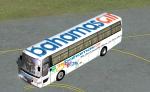
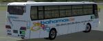
Hama 1000 Airport Transit Bus Bahamasair Textures
(Category: FSX > Misc)
0.37Mb (1928 downloads)
Hama 1000 airport bus with a fictional livery for Bahamasair. Original credits to Mitsuya Hamaguchi for model with ricardo_tv update.
Required files:
required file
Posted May 25, 2012 21:15 by nickthatch12
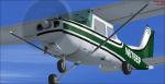
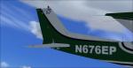
Cessna 172 N676EP Textures
(Category: FSX > Props)
5.92Mb (556 downloads)
Textures only for the default Cessna 172 in the fictional N676EP. It is a green Cessna 172 with some black. The livery and the tail number is fictional. There are instructions on how to install in the readme file. By Tyler Lawrence.
Posted May 25, 2012 18:41 by Tyler Lawrence
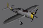
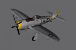
FSX P47 Static Plane Scenery Design Object
(Category: FS Design > Scenery Design Objects)
0.69Mb (551 downloads)
This is the Republic P47 Static plane for FSX. The plane comes in a library and also as a model. The P47 can be placed in any FSX scenery by any object placement tool. The P47 comes in one model (US Silver). The P47 was made in GMax by Guy Diotte and the texture also by Guy Diotte.
Posted May 25, 2012 18:36 by Guy Diotte
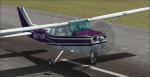
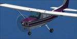
Cessna 172 N971JR Textures
(Category: FSX > Props)
5.84Mb (401 downloads)
Textures only for the default Cessna 172 in the fictional N971JR. It is a purple Cessna 172 with some black. The livery and the tail number are fictional. There are instructions on how to install in the readme file. By Tyler Lawrence.
Posted May 25, 2012 18:36 by Tyler Lawrence