


All Files > Page 932
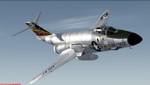
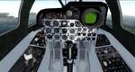
FSX/P3D McDonnell F-101 1-str Package
(Category: FSX > Military)
65.80Mb (4196 downloads)
FSX/P3D McDonnell F-101 1-str Package. This is an updating of Henk Schuitemaker's FSX conversion of the freeware Alphasim/Virtavia F-101A/C and RF-101A/C models. It contains updated textures for F-101A/C, 81st TFW repaints, plus a set of RF-101 textures. Individual spec panels have been added and alpha channels enabled on the models. The texture sets have been revised to give a more realistic metallic finish where appropriate. The package has been tested in FSX Acceleration and P3D by Dave Quincey, Henk and Jens-Ole Kjolberg
Posted Jul 13, 2016 06:59 by uploader
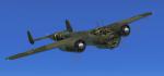
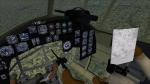
FSX Dornier Do-17z Upgrade
(Category: FSX > Vintage)
11.44Mb (1669 downloads)
FSX Dornier Do-17z Upgrade. The new build WWII warbird has a complete virtual cockpit with crew and FSX-compatible gauges. Eleven cameras and weapon effects are configured. The model is made by Chris Lampard, the 2D panel is made by Lobo, the virtual cockpit with crew by Mark Shelley and FSX-configuration by Erwin Welker
Posted Jul 13, 2016 05:41 by Erwin Welker
.jpg-thumb.jpg)
.jpg-thumb.jpg)
FSX Added Views For IOWA-Class Battleships
(Category: FSX > Misc)
0.22Mb (450 downloads)
FSX Added views for the IOWA-Class Battleship package from Dave Carroll. Requires "icbdc01.zip". Eightteen camera views let you explore the huge ship, from the bow to the stern, from the upper observation station to the control station in front of the rear deck. Just copy and paste my camera definitions somewhere into the aircraft.cfg. Camera configuration by Erwin Welker
Required files:
required file
Posted Jul 13, 2016 03:05 by Erwin Welker
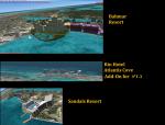
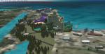
Nassau Bahamas Landmarks 3
(Category: FSX > Scenery)
5.40Mb (1310 downloads)
The 3rd Chapter to Nassau Bahamas' Local Scenery. This file includes the new Bahmar Resort, Sandals Resort, the RIU hotel, Atlantis Cove Hotel and surrounding scenery that was left out of the previous atlantis landmark file..
Posted Jul 12, 2016 15:11 by Shawn Penn
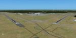
Jacksonville International Airport KJAX, Florida
(Category: FSX > Scenery)
9.81Mb (1038 downloads)
Jacksonville International Airport is a Class C airport in Jacksonville Florida. It's the primary airport with Airline service in Jacksonville. Jacksonville itself is the largest city in the US continuous 48 when measured by land area. Over the past 10 years it has seen extensive renovations making the default very different from reality. Art Poole updated the airport adding the New Terminal, and various custom made buildings. But its been some years since Art's scenery and the airport has seen even more construction. This scenery will update Art Poole's scenery to the airports current state. This scenery is self contained and requires no additional downloads. Special features includes a custom AFCAD, extensive use of GP objects, Updated Instrument approaches (Including RNAV-Y Approaches), Custom Lighting, And several other features. Updated by CountryFlyboy
Posted Jul 12, 2016 14:53 by CountryFlyboy
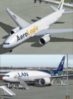
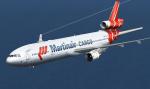
FSX/P3D Boeing 777-200F LAN Cargo & AeroLogic twin aircraft package
(Category: FSX > Civil Jets)
83.83Mb (3583 downloads)
Boeing 777-200F LAN Cargo & AeroLogic twin aircraft package. Model by Project Opensky. Models include VC's with FMC, ground servicing and more.
Posted Jul 12, 2016 03:18 by Hannes Nemitz
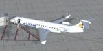
FSX Bombardier CRJ 700 Brit Air
(Category: FSX > Civil Jets)
11.13Mb (1287 downloads)
Everyone knows this very popular, fast and comfortable aircraft. Original design by Project Skyworks. VC modifications, panels for wide and standard screen, GPWS callout, gauges by Philippe Wallaert. See instructions in the readme.txt file. Enjoy!
Posted Jul 11, 2016 12:13 by Philippe Wallaert
FSX/FS2004 McDonnell Douglas MD-11CF Martinair Cargo PH-MCP
(Category: FSX > Civil Jets)
45.86Mb (3973 downloads)
This pack contains: SMS overland model of the Md-11PW. Also contains: VC / FMC / High quality textures of the PH-MCP. Martinair's last MD-11. Also contains custom PW4000 sounds. Repainted by Mees Jansen
Posted Jul 11, 2016 11:09 by Mees Jansen
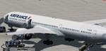
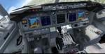
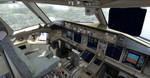
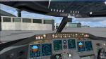
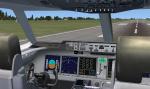
FSX/P3D Boeing 787-10 Air France Package
(Category: FSX > Civil Jets)
93.87Mb (4151 downloads)
FSX/P3D Boeing 787-10 Air France package with enhanced VC.
Air France is currently (2016) negotiating a previous order for 14 Boeing 787 jetliners.
The high detail native FSX Boeing 787-10 from TDS will be enjoyed by many more people who do not know how to install a VC into a FSX native model. Model includes ground servicing, fuel truck, cargo, etc. Now the 787-8 has the nearest VC I can find -- the 737-800. The layout of the 787 cockpit is not a million miles away from the advanced 737-800.
The VC is the Alejandro Rojas Lucena/FSND fantastic revised Boeing 737-800 VC model blended with Ken Wiggington's revisions for the default B737 VC to make it more resemble a 787. This VC model includes Working wipers (right mouse click on switch) with rain effect. Switches for LCD Screens, EICAS, PFD, MFT. Autobrake switch. Opening pilots window. Cabin Lights switch. Realistic FMC. Ground Proximity Warning System (GPWS), More Realistic night VC textures. There are custom Boeing sounds included for that extra realism.
I added the great textures by Alejandro Magadan.
Model is not modified in any way. The VC added and aircraft.cfg edited to allow correct VC views.
Manuals included. See VC docs to get the best out of the VC and FMC.
Assembled and prepared for Prepar3d/FSX by Chris Evans.
Posted Jul 11, 2016 09:22 by chris evans
FSX/Prepar3D Scenery - Santa Barbara del Zulia-SVSZ, Venezuela package
(Category: FSX > Scenery)
58.42Mb (1140 downloads)
FSX/Prepar3D Scenery - Santa Barbara del Zulia-SVSZ
The "Miguel Urdaneta Fernandez" National Airport serves the cattle town of Santa Barbara del Zulia,
located south of Lake Maracaibo in Zulia state. Serves air link between South Lake region
and the capital of Zulia state, Maracaibo.
Photo-terrain area improved with Autogen files.
Only compatible with versions to FSX or P3Dv1v2v3.x.
Also includes a friendly Auto-Install.
By David Maldonado
Posted Jul 10, 2016 11:42 by David Maldonado