


All Files > Page 933
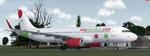
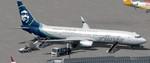
Airbus A320 VivaAerobus
(Category: FSX > Civil Jets)
55.41Mb (2752 downloads)
Airbus A320 VivaAerobus XA-VAA y XA-VAK twin livery. Vivaaerobus is a Mexican low cost carrier part owned by Irish airline Ryanair. Textures by Luis Enrique R. Matricula. Model by Project Airbus. 2d panel only - NO VC. (use F10 to see default A321 2d panel)
Posted Jul 10, 2016 04:48 by Luis Enrique R
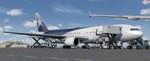
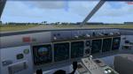
P3D/FSX Boeing 767-300 Latam/Lan Package
(Category: FSX > Civil Jets)
65.38Mb (4105 downloads)
P3D/FSX Boeing 767-300 Latam/Lan package with advanced VC. Winglet and non winglet models included.
Chile based airline Latam (formerly Lan) currently (2016) operate 23 Boeing 767-300ER aircraft.
Native FSX B767-300ER model by Skyspirit
with advanced 737-800 VC added. Includes utility for ground services, cargo, stairs, etc (FSX find it under - Views/P3D Vehicle - Instrument panel - - Posky Utility)
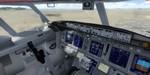
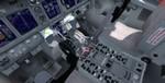
The fabulous freeware native FSX Boeing 767-300ER from Skyspirit will be enjoyed by many more people who do not know how to install a VC, views, exits, Utilities etc into a FSX native model. The layout fof the 767 cockpit is not a million miles away from the advanced 737-800.
The VC is the Alejandro Rojas Lucena/FSND fantastic revised Boeing 737-800 VC model. This VC model includes Working wipers (right mouse click on switch) with rain effect. Switches for LCD Screens, EICAS, PFD, MFT. Autobrake switch. Opening pilots window. Cabin Lights switch. Realistic FMC. Ground Proximity Warning System (GPWS), More Realistic night VC textures. There are custom Boeing sounds included for that extra realism. Jetways also edited (Ctrl j). Exits and views corrected for FSX/P3d.
I have added the superb textures by Philip Folgar and added 767 sounds for more realism.
Model is not modified in any way.
See VC docs to get the best out of the VC and FMC.
Packaged for P3D/FSX by Chris Evans.
Posted Jul 9, 2016 08:35 by chris evans
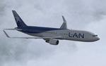
Boeing 767-300 Lan Airlines
(Category: FS2004 > Civil Jets)
18.35Mb (1450 downloads)
Boeing 767-300 Lan Airlines. Model features High resolution textures, Dynamic flexing wings, Nose gear steering, Rudder lock, Ground spoilers, Low speed aileron locks at high speed, Fully animated control surfaces, Fully independent suspension, Trim Animation, Opening Passenger Doors, Animated tilting bogies, Rolling wheels, Animated thrust reverser's with reverser block doors, Detailed textures, Full night lighting, Crash affects, Ground Service Vehicles And more. Model Designer Hiroshi Igami/Yosuke Ube. Flight Dynamics Designer Warren C. Daniel. Textures by Philip Foglar. Livery by Philip Foglar.
Posted Jul 9, 2016 07:22 by chris evans
FSX/Prepar3D Boeing 737-900ER Alaska Airlines 'Boeing 100 Years' Package
(Category: FSX > Civil Jets)
70.97Mb (3885 downloads)
FSX/Prepar3D Boeing 737-900ER Alaska Airlines 'Boeing 100 Years' Package with enhanced VC.
Alaska currently (2016) operate 153 Boeing 737-900ER and this special livery was delivered as part of Boeing celebrating it's 100th birthday in 2016.
Boeing 737-900ER Model by TDS/ Tenkuu Developers Studio
with advanced 737-800 VC added. Includes utility for ground services, Passenger bus, cargo, stairs, refuelling truck etc (find it under - Views - Instrument panel - Util /or in P3D - Vehicle - Instrument panel)
The wonderful native FSX Boeing 737-900 from TDS will be enjoyed by many more people now, assembled in one tested and ready to fly package.
The VC is the Alejandro Rojas Lucena/FSND fantastic revised Boeing 737-800 VC model. This VC model includes Working wipers (right mouse click on switch) with rain effect. Switches for LCD Screens, EICAS, PFD, MFT. Autobrake switch. Opening pilots window. Cabin Lights switch. Realistic FMC. Ground Proximity Warning System (GPWS), More Realistic night VC textures. There are custom Boeing sounds included for that extra realism.
I have added the photoreal textures by Joe Shimmel.
Model is not modified in any way. VC added and aircraft.cfg edited to allow correct VC views.
TDS wonderful native FSX Boeing 737-900ER model. See VC docs to get the best out of the VC and FMC.
Assembled and prepared for FSX/P3D by Chris Evans.
Posted Jul 8, 2016 08:01 by chris evans
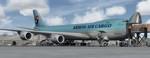
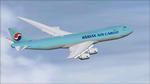
P3D/FSX Boeing 747-8F Korean Air Cargo package
(Category: FSX > Civil Jets)
35.19Mb (2792 downloads)
P3D/FSX Boeing 747-8F Korean Air Cargo package with enhanced VC.
As of 2016, Korean Air Cargo operate 6 Boeing 747-8F aircraft with a further 4 on order.
Project Opensky native FSX Boeing 747-8F assembled and upgraded for FSX with the developed B747 VC (3d virtual cockpit) from Alejandro Rojas Lucenda (Manual included). This is the Project Opensky FSX native Boeing 747-800F model, and includes ground cargo servicing, stairs (FSX - Go to Views/P3D go to Vehicle - Instrument Panel -Posky Utility), opening nose section and more.
Custon sounds included.
Thank you to Project Opensky for their contributions to the worldwide community of flight simulation. I have included the superb textures by Mathieu Vos.
Also includes the Boeing 747 VC textures upgrade. This give a much clearer 747 interior virtual cockpit look.
Assembled and edited for FSX by Chris Evans.
Posted Jul 7, 2016 13:36 by chris evans
Boeing 747-8F Korean Air Cargo
(Category: FS2004 > Civil Jets)
19.38Mb (699 downloads)
Boeing 747-8F Korean Air Cargo package. Model by Project Opensky. Textures by Mathieu Vos.
Posted Jul 7, 2016 12:04 by chrisE
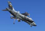
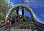
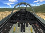
FSX VFW Fokker VAK-191B VTOL-Fighter Bomber
(Category: FSX > Military)
21.20Mb (3117 downloads)
FSX/Acceleration VFW Fokker VAK-191B VTOL fighter bomber prototype. Great Britain, Italy and Germany began 1961 a common develepment of a VTOL fighter project. Some years later the three countries seperated the common development and continiued in different projects. Germanys VAK-191B made its first flight in 1971, Germany's parallel supersonic project EWR VJ-101 made its first flight in 1963, Italys Fiat G.95 supersonic project was abandoned in 1986 and Britains Hawker P.1127 led via the Kestrel finally to the Harrier; the only one which went into production. Today the VAK-191B is displayed in the Deutsche Museum Munich at the historical airport Oberschleissheim together with the VTOL supersonic fighter prototyp EWR VJ-101 and the VTOL-transporter prototype Do-31E3. My package provides the VAK-191B prototype and the proposed fighter bomber with weapons and a fictional camo paint scheme. The FS model has 59 moving parts and has an excellent and easy to fly VTOL flight behavior. The VTOL option comes from the great RCB-gauges from Rob Barendregt. This is a whole airplane with 2D-panel and VC, regarding to the original instrument panel. FSDS 3.5 model and panel by Erwin Welker.
Posted Jul 7, 2016 03:41 by Erwin Welker
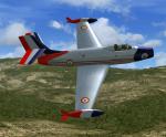
FS2004/FSX Dassault MD.450 Ouragan
(Category: FSX > Military)
9.58Mb (1888 downloads)
FS2004/FSX Dassault MD.450 Ouragan
The Dassault MD.450 "Ouragan" (meaning "Hurricane") became France's first
home-grown operational, jet-powered, military combat fighter, eventually being
produced in several hundred examples during her active tenure. While not a
wholly exceptional "fighter" when compared to her contemporaries, the type
served particularly well in the fighter-bomber role and saw extensive combat
actions with India, El Salvador and Israel. GMAX mdl by A.F.Scrub
Posted Jul 6, 2016 15:19 by A.F.Scrub
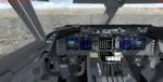
FSX/P3D Boeing 787-10 American Airlines Package
(Category: FSX > Civil Jets)
67.50Mb (6246 downloads)
FSX/P3D Boeing 787-10 American Airlines with enhanced VC.
American Airlines have (2016) 22 Boeing 787-900 on order but no 787-10 - although they may in the furture.
Model by TDS/ Tenkuu Developers Studio
with advanced 737-800 VC added.
The high detail native FSX Boeing 787-10 from TDS will be enjoyed by many more people who do not know how to install a VC into a FSX native model. Model includes ground servicing, fuel truck, cargo, etc. Now the 787-8 has the nearest VC I can find -- the 737-800. The layout of the 787 cockpit is not a million miles away from the advanced 737-800.
The VC is the Alejandro Rojas Lucena/FSND fantastic revised Boeing 737-800 VC model. This VC model includes Working wipers (right mouse click on switch) with rain effect. Switches for LCD Screens, EICAS, PFD, MFT. Autobrake switch. Opening pilots window. Cabin Lights switch. Realistic FMC. Ground Proximity Warning System (GPWS), More Realistic night VC textures. There are custom Boeing sounds included for that extra realism.
I added the hi def. textures by Triadi Sudarmawan.
Model is not modified in any way. The VC added and aircraft.cfg edited to allow correct VC views.
Manuals included. See VC docs to get the best out of the VC and FMC.
Assembled and prepared for Prepar3d/FSX by Chris Evans.
Posted Jul 6, 2016 10:06 by chris evans
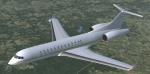
FSX Bombardier BD 700 Global Express
(Category: FSX > Civil Jets)
11.32Mb (2446 downloads)
This business jet is a hight speed and long range aircraft. First flight in 1996. Based on model by Thinus Pretorius. VC, 2D panel for wide and standard screen, GPWS callout by Philippe Wallaert. See instructions for installation in the readme.txt file. Credits: Thinus Pretorius for his excellent model.
Posted Jul 5, 2016 10:21 by Philippe Wallaert