


All Files > Page 1556
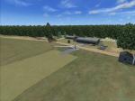
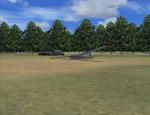
EDBQ-Bronkow, Germany
(Category: FSX > Scenery)
0.34Mb (545 downloads)
Bronkow(EDBQ), Germany. Bronkow is a light aviation and gliding airfield in Germany with grass strips. Improvement over the default FSX Bronkow.
Posted Dec 23, 2012 09:33 by Felix
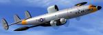
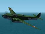
EC-121 Warning Star Textures
(Category: FSX > Military)
3.20Mb (693 downloads)
EC-121 Warning Star textures for Danny Garnier's FSX update of the Alphasim RC-121D, as an EC-121D of the 551st. AEW & C Wing, Otis AFB, Massachusetts.
Required files:
required file
Posted Dec 23, 2012 05:01 by Michael E. Roberts
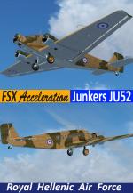
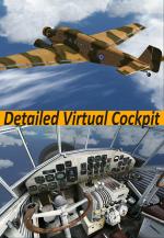
FSX Acceleration Junkers Ju-52 RHAF Package
(Category: FSX > Vintage)
30.62Mb (7125 downloads)
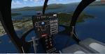
FSX Acceleration Junkers Ju-52 RHAF package. Three Ju-52 aircraft were delivered in June 28 1938 to supplement the existing 4 Ju G24he's of the First Hellenic Airways (EEES) fleet. With the outbreak of War in 1940 they were send to the Royal Hellenic Air Force as transporters. Painted in camouflage colors (Light earth dark green) and bearing roundels on the underside of the wing and fuselage. Model by O.Fischer, featuring detailed virtual cockpit, 2d panel and sound. Repaint for FSX by Hellenic Aircraft/Yiannis Katehis Tsetsas.
Posted Dec 23, 2012 02:47 by YIANNIS KATEHIS TSETSAS
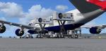
LSG Sky Chef Posky 747 Ground Services Textures
(Category: FSX > Civil Jets)
0.34Mb (2330 downloads)
LSG Sky Chefs catering truck textures for the Air Service trucks on Project Opensky Boeing 747 models. Works in any Project Opensky B747 with the 'Os_ct*' in the textures folder. LSG Sky Chefs operates world wide therefore is seen at almost every major airport. Add some realism to your gate! Only for -Project Opensky B747 400 and 800 series models.
Posted Dec 23, 2012 00:32 by Andy A
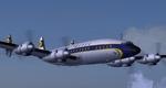
Lockheed L-1649A Starliner
(Category: FS2004 > Vintage)
14.87Mb (4995 downloads)
FS2004 Lockheed L-1649A Starliner
The Starliner was the final developement of
the Lockheed Constellation series with
extended range for non-stop transatlantic
service. Complete Aircraft with improved
visual model and flight dynamics. Complete
manual and performance charts. Ver. 4.0. By
Volker Böhme, Luis Pallas, Bill Tyne and
Stefan Werner. Textures by Tim Scharnhop.
Posted Dec 22, 2012 15:34 by uploader
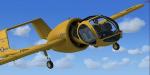
Edgley Optica Package
(Category: FSX > Props)
27.11Mb (7635 downloads)
The Optica, designed by John Edgley and built by Brooklands Aerospace, had an unusual configuration with a fully glazed forward cabin seating three across. Full animations, 3D gauges and Baked Textures. By Craig Richardson @ www.Classicwings.net Flight Model by Pam Brooker.
Posted Dec 22, 2012 12:41 by uploader
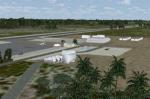
Inagua - The Bahamas (MYIG)
(Category: FSX > Scenery)
0.74Mb (1116 downloads)
Inagua - The Bahamas (MYIG). MYIG is the southernmost airport in the Bahamas. At nearby Matthew Town is the Morton Salt Company's main facility - Inagua's main industry. The scenery includes custom scenery objects; placement of library objects and landclass changes. The airport is also moved to it's proper location. Scenery is based on Google Earth and Microsoft Bing imagery and photos taken locally, and it is optimized for use with or without UTX-TAC. By: Art Poole
Posted Dec 22, 2012 12:28 by art poole
Bloch MB131C French Bomber
(Category: FS2004 > Vintage)
15.79Mb (1390 downloads)
FS2004/2002/CFS2 Bloch MB131C
The Bloch 131 was developed from the Bloch 130.01 Guynemer prototype. It flew in July 1934 and was completely redesigned,with a glazed nose and tall single fin and rudder, and powered by two 708kW Gnome-Rhone 14N radial engines. A retractable undercarriage was fitted. Armament comprised 7.5mm machine-guns in nose, dorsal turret and ventral positions. One hundred and thirty-nine production Bloch 131 were built for the Armee de l'Air in the RB4 category as four-crew machines intended for bombing and reconnaissance. The first six aircraft were delivered by June 1938, the rest by September 1939. Most went to Reconnaissance Groupes, suffering heavy losses at the beginning of the 'Phoney War' period. From October 1939 the type was used only for occasional night missions and for training. The max bomb load in various combinations was 800kg. Following France's capitulation, the Vichy regime used surviving Bloch 131s for target-towing. This is Alain Breton old mdl reworked by A.F.Scrub for CFS2/FS8/FS9 flightsims.
Posted Dec 22, 2012 11:41 by A.F.Scrub
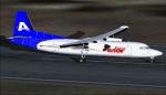
Fokker 50 Avior Regional Concepto
(Category: FS2004 > Props)
11.12Mb (1882 downloads)
FS2004 Avior Regional Fokker 50 Concepto. Model by DreamWings, textures by Jose Blanco.
Posted Dec 22, 2012 09:54 by Jose Blanco
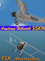
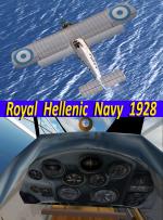
FSXA Armstrong Withworth Siskin RHN Package
(Category: FSX > Vintage)
12.59Mb (1305 downloads)
FSX Acceleration Armstrong Withworth Siskin RHN package. The specific repaint resembles an ATLAS type Armstrong-Withworth that was buid by the Hellenic Aircraft Industries(Later KEA) at 1928 ordered by the Royal Hellenic Navy Air Service. The Hellenic ATLAS had differences from the British type such as the motor, wing structure slats, etc. They had codes M101-M112 and light blue roundels on the wings. All painted with aluminum paint and black. Unit: 12 aircraft: Naval Air Service [until 1930]as Naval-Army cooperation,RHAF. [after 1930] Model by: A.F.Scrub with all moving parts, full virtual cockpit, 2D panel, gun effects & sound. All 32 bit DDS5 semi-transparent textures. I have added the missing glass texture and fixed the prop disk transparency for Acceleration. Modifications & repaint for FSX by Hellenic Aircraft/Yiannis Katehis Tsetsas.
Posted Dec 22, 2012 01:44 by YIANNIS KATEHIS TSETSAS