


All Files > Page 1558
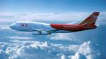
Boeing 747-400 Oasis Hong Kong
(Category: FSX > Civil Jets)
59.74Mb (5830 downloads)
Boeing 747-400 in Oasis Hong Kong. Oasis Hong Kong Airlines Limited was a long-haul low-cost airline based in Hong Kong. It operated scheduled services to London Gatwick Airport and Vancouver International Airport from its hub, Hong Kong International Airport. This was a great livery. Shame it's still not with us, lasted only two years. Default 747 VC included. Model by Project Opensky. Painted by Stephen Browning.
Posted Dec 19, 2012 18:25 by Stephen Browning
FSX Airbus A310-300 North Central Airlines Textures
(Category: FSX > Civil Jets)
4.23Mb (1072 downloads)
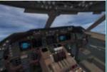
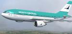
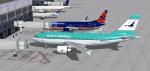
FSX Airbus A310-300 textures for 'what if' North Central
Airlines was still in business. Updated new livery N22157, for the
wonderful Thomas Ruth A310-300, which you must have previously
installed in FSX. Includes cfg entries for either GE and/or PW
engines. Screenshots enclosed. Easy installation.
By Tom Tiedman.
Required files:
required file
Posted Dec 19, 2012 18:17 by Tom Tiedman
FSX Added Views for the Avia-56 Amphibious Floatplane
(Category: FSX > Props)
0.25Mb (583 downloads)
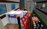
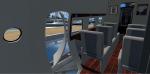
FSX added views for Avia-56 from Milton Shupe, Nigel Richards, John Smith, and James Banks with help from SOH members (Requires Requires Av56ms.zip). The camera definitions provides 4 aircraft- and 4 cabin views. They show the best spots for the detailed interior for the passenger- and especially for the amazing cargo-version. I have lifted the rear contact points for water of the Amphibium. Please check it out. Configuration by Erwin Welker
Required files:
required file
Posted Dec 19, 2012 07:14 by Erwin Welker
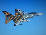
F-16 Viper BAF Tigermeet 2012 Textures
(Category: FSX > Military)
4.48Mb (2456 downloads)
The Belgain Tigermeet 2012 colorscheme. Textures only. Requires Kirk Olsson's Viper updated for FSX. Textures made by: Mees Jansen.
Required files:
required file
Posted Dec 19, 2012 02:27 by Mees Jansen
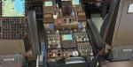
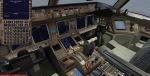
Boeing 777-223ER American Airlines Oneworld N796AN with new Virtual Cockpit
(Category: FSX > Civil Jets)
76.65Mb (9113 downloads)
Boeing 777-223ER American Airlines Oneworld N796AN with new Virtual Cockpit and FMC for FSX.
Boeing 777-223ER American Airlines Oneworld N796AN. Includes revised VC and FMC (via Views-Instrument panel). Model features are Opening doors & Cargo doors, detailed textures, accurate paint, dynamic shine & effects, dynamic flexing wings that respond to turbulence, fully independent suspension, trim animation, gear steering, accurate flight dynamics, spoiler animation, reflective cockpit windows, crash effects, animated tilting bogies, full night lighting, ground service vehicles when cargo
door open, (FSX - Go to Views - Instrument Panel -Posky Utility), detailed virtual cockpit and more. Model, VC model by Project Opensky and professionally textured by Xudeva Irribarra. Mods for FSX by Chris Evans. See FMC docs. FMC needs to be set in Flight Planning in FSX. (you cannot enter into the FMC direct)
Posted Dec 19, 2012 02:01 by Chris Evans
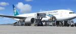
Boeing 777-200ER Air New Zealand with new VC
(Category: FSX > Civil Jets)
74.83Mb (7043 downloads)
Boeing 777-200ER Air New Zealand with new Virtual Cockpit and FMC for FSX.
Boeing 777-200/ER Air New Zealand . Includes revised VC and FMC (via Views-Instrument panel). Model features are Opening doors & Cargo doors, detailed textures, accurate paint, dynamic shine & effects, dynamic flexing wings that respond to turbulence, fully independent suspension, trim animation, gear steering, accurate flight dynamics, spoiler animation, reflective cockpit windows, crash effects, animated tilting bogies, full night lighting, ground service vehicles when cargo
door open, (FSX - Go to Views - Instrument Panel -Posky Utility), detailed virtual cockpit and more. Model, VC model by Project Opensky and professionally textured by Ryan Gabuyo. Mods for FSX by Chris Evans. See FMC docs. The FMC needs to be set within the FSX flightplan.
Posted Dec 18, 2012 14:01 by Chris Evans
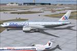
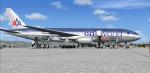
American Airlines Oneworld Boeing 777-200/ER
(Category: FS2004 > Civil Jets)
27.02Mb (2093 downloads)
American Airlines Oneworld Boeing 777-200/ER Registration "N791AN" Painted on SkySpirit2012 Boeing 777-200/ER aircraft. The textures are saved in 32bit format for quality graphics. Its features are Opening doors & Cargo doors, detailed textures, accurate paint, dynamic shine & effects, dynamic flexing wings that respond to turbulence, fully independent suspension, trim animation, gear steering, accurate flight dynamics, spoiler animation, reflective cockpit windows, crash effects, animated tilting bogies, full night lighting, ground service vehicles when cargo
door open, transparent navigation light lenses and many more.
Thanks for downloading & Happy flying.
Carlos Eduardo Salas
Posted Dec 18, 2012 13:32 by Chris E
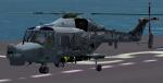
FSX textures for Alphasim Westland Future Lynx Navy helicopters
(Category: FSX > Military)
4.74Mb (1332 downloads)
FSX texture repaint for Alphasim Westland Future Lynx Navy helicopters (Lynxupdate.zip required) in a special "Black Cat" paintscheme. The model differs a little to the real one. My repaint is for the Navy versions. Reworked camera definitions are included. Repaint by Erwin Welker.
Required files:
required file
Posted Dec 18, 2012 12:21 by Erwin Welker
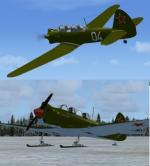
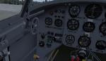
1947 Yak-18 "Max" Package
(Category: FSX > Vintage)
21.17Mb (2699 downloads)
1947 Yak-18 "Max", reworked beta for FSX only.
Models & textures by SWingman, 2D-gauges by Wishmaster (Mikhail Mityn)
Special thanks to Kirill Konovalov and Don Bodenstedt.
Posted Dec 18, 2012 12:10 by uploader
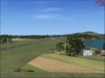
Donegal Airport, Ireland
(Category: FSX > Scenery)
1.05Mb (797 downloads)
Donegal Airport, Ireland. Improvement over the default FSX Donegal.
Posted Dec 18, 2012 11:57 by uploader