


All Files > Page 1597
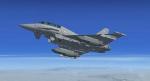
Eurofighter Typhoon Package
(Category: FS2004 > Military)
43.08Mb (14066 downloads)
Eurofighter Typhoon is a highly advanced, extremely maneuverable attack aircraft manufactured by a European consortium of several concerns. Said to have "carefree handling" by its manufacturers, the aircraft incorporates advanced avionics, weapons systems, and control systems. Ex payware from Virtuavia/Alphasim with custom VC, sounds and multiple models.
Posted Oct 27, 2012 04:02 by alphasim
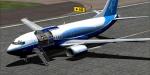
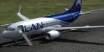
Boeing 737 Mega-Package Vol.4 / 737-BBJ, -BBJ2, AEW&C, C-40 & P-8
(Category: FSX > Civil Jets)
321.59Mb (19757 downloads)
(Corrected Version) Project Opensky Volume 4 of the Boeing 737 Mega-Package for Flight Simulator X. It includes the advanced 737NG Panel from Alejandro Lucena including GPWS, FMC, AutoBrake and several more systems, 4 Boeing 737 models created by the Project Opensky team (containing the 737-BBJ, 737-BBJ2, 737 AEW&C, C-40 and P-8 Poseidon), CFM International CFM56-7B sounds created by Emil Serafino, 16 High-Quality Liveries divided the already mentioned 737 variants, Read-Me file with easy installation instructions and more details about this package. For a more detailed Description, Images, and other great packages at: -fsxluchoals.blogspot.com-
Posted Oct 27, 2012 00:57 by Luis Quintero
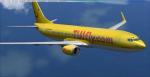
Boeing 737 Mega-Package Vol.3 / 737-700C, -800 & -900
(Category: FSX > Civil Jets)
361.63Mb (21014 downloads)
(Corrected Version) Project Opensky/Alejandro Lucena Volume 3 of the Boeing 737 Mega-Package for Flight Simulator X. It includes the advanced 737NG Panel and Virtual Cockpit from Alejandro Lucena including GPWS, FMC, AutoBrake and several more systems (VC available just in the -800 and -900) , 10 Boeing 737 models created by the Project Opensky team (containing the 737-700C, 737-800 and 737-900), CFM International CFM56-7B sounds created by Emil Serafino, 41 High-Quality Liveries divided the already mentioned 737 variants, Read-Me file with easy installation instructions and more details about this package. For a more detailed Description, Images, and other great packages at: -fsxluchoals.blogspot.com-
Posted Oct 26, 2012 22:47 by Luis Quintero

FS2004/FSX Boeing 777-200 Textures
(Category: FS2004 > Civil Jets)
18.92Mb (1343 downloads)
FS2004/FSX Boeing 777-200 Textures for the Project Opensky Boeing 777-200ER. Scoot airlines is a Singapore-based low-cost long-haul airline. It operates flights on medium and long-haul routes from Singapore, initially to Australia and China, using Boeing 777 aircraft obtained from its parent company, Singapore Airlines. Photoreal textures in 32 bit format for the model freeware Project Opensky Boeing 777-200 Version 2 (model not included ). Repaint be Manuel Jose.Contact Ground.Happy flights.
Posted Oct 26, 2012 21:56 by Manuel Jose Larrahondo Burgos
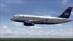
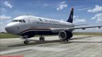
Airbus 319 IAE US Airways
(Category: FS2004 > Civil Jets)
22.80Mb (2969 downloads)
Airbus A 319 IAE engines in US Airways livery. Complete aircraft included. Model by Project Airbus.
Posted Oct 26, 2012 20:29 by LUIS CASTRO
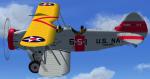
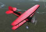
Berliner Joyce OJ-2
(Category: FSX > Vintage)
15.64Mb (2191 downloads)
The Berliner Joyce OJ-2 was designed as both a land based and sea plane based scout plane. They were originally delivered with wheels and then later converted to floats. This is a native FSX Acceleration project which includes both the land and sea based versions. The liveries are for VS-5B and VS-6B which were assigned to US Navy heavy cruisers.The P & W R-985 sound file is by Mike Hambly. The VC is animated and has back lighted instruments for night ops.
Posted Oct 26, 2012 17:57 by Paul Clawson
Boeing 737 Mega-Package Vol.2 / 737-600 & -700
(Category: FSX > Civil Jets)
496.91Mb (10638 downloads)
(Corrected Version) Project Opensky/Alejandro Lucena Volume 2 of the Boeing 737 Mega-Package for Flight Simulator X. It includes the advanced 737NG Panel and Virtual Cockpit from Alejandro Lucena including GPWS, FMC, AutoBrake and several more systems, 8 Boeing 737 models created by the Project Opensky team (containing the 737-600 and 737-700), CFM International CFM56-7B sounds created by Emil Serafino, 78 High-Quality Liveries divided the already mentioned 737 variants, Read-Me file with easy installation instructions and more details about this package. For a more detailed Description, Images, and other great packages at: -fsxluchoals.blogspot.com-
Posted Oct 25, 2012 23:09 by Luis Quintero
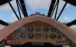
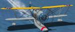
The Vintage Wings of Canada 1928 WACO ATO Taperwing
(Category: FSX > Vintage)
17.09Mb (4162 downloads)
This is the freeware Golden Age Simulations WACO CTO Mailwing in the livery of the 1928 WACO ATO Taperwing of the Vingate Wings of Canada, registration number CF-BPM. The package includes the original model and basic texture by Golden Age Simulations, the sound pack by Tim Dement, the corrected flight dynamics (for the ATO Taperwing, powered by the Wright J6-9 Whirlwind engine), as well as the new livery and panel staff. The Vingate Wings of Canada 1928 WACO ATO Tapering CF-BPM was manufactured in 1929 at The Advanced Aircraft Co., Troy, Ohio (serial number - CN A-65). Originaly powered by Wright J-5 engine, the plane later was upgraded
to J-6 with Hamilton Standard propeller.
VC panel, livery and flight dynamics by Vladimir Gonchar
Posted Oct 25, 2012 22:47 by Vladimir Gonchar
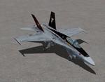
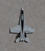
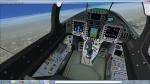
Views 2.0 for the FSX Acceleration Boeing F/A-18A
(Category: FSX > Military)
0.10Mb (2017 downloads)
This package contains 2 sets of camera views ( defined by camera definitions in the aircraft.cfg file ) for
the beautiful Boeing F/A-18A Hornet by Microsoft available only in the Acceleration expansion Pack.
Version 1.1 is actually based on my original package but with more views and some slight mods
to some parameters.
Version 2.0 is based on version 1.1 but some of the cameras are place at a higher level.
Three new views : top-down zoomable view of the aircraft. 2 VC "Over the shoulder" views.
See Read me.txt file for very easy installation procedures.
Camera definitions sets are included in 2 separate text files.
And finally two more files - Available.pdf and Top 20.pdf for informations
about my "camera definitions" packages.
Posted Oct 25, 2012 22:14 by Marc Renaud
Boeing 737 Mega-Package Vol.1 / 737-200, -200Advanced, -300, -400 & -500
(Category: FSX > Civil Jets)
319.43Mb (35125 downloads)
(Corrected Version) TinMouse/Vistaliners Volume 1 of the Boeing 737 Mega-Package for Flight Simulator X. It includes the advanced 737NG Panel from Alejandro Lucena including GPWS, FMC, AutoBrake and several more systems, 9 Boeing 737 models created by the Vistaliners and TinMouse teams (containing the 737-200, 737-200 Advanced and 737 Classic family), Pratt & Whitney JT8D-200 and CFM International CFM56-7B sounds created by Adam Murphy and Devyn Silverstein, 89 Liveries divided the already mentioned 737 variants, Read-Me file with easy installation instructions and more details about this package. Does not include a Virtual Cockpit. For a more detailed Description, Images, and other great packages at: -fsxluchoals.blogspot.com-
Posted Oct 25, 2012 21:49 by Luis Quintero