


All Files > Page 1598
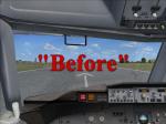

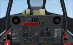
FSX Boeing 737-800 Cockpit Textures Upgrade
(Category: FSX > Civil Jets)
25.81Mb (4824 downloads)
B737-800 FSX VC cockpit textures upgrade. This package contains textures that will make the default FSX B737-800 cockpit textures appear in full resolution and with more color and details.
VC repaint by:
Enrique Cornejo
Posted Oct 25, 2012 21:41 by Enrique Cornejo
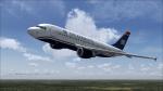
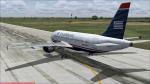
Airbus 319 114 US Airways
(Category: FS2004 > Civil Jets)
22.76Mb (1389 downloads)
Airbus A 319-114 IN "US Airways" livery. Complete aircraft included. Model by Project Airbus. Textures by Luis Castro.
Posted Oct 25, 2012 19:39 by LUIS CASTRO
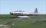
Republic F-84G Thunderjet
(Category: FSX > Vintage)
19.16Mb (2981 downloads)
Jens B. Kristensens great Republic F-84G Thunderjet, now flyable in FSX-Acceleration. All credits go to him!! Six liveries, updated panel with full working VC (all necessary gauges included), smoke and afterburner effects for fun. Enjoy!
Posted Oct 25, 2012 18:13 by erik hertzberger


A320 Thomas Cook Textures
(Category: FSX > Civil Jets)
13.45Mb (2353 downloads)
Thomas Cook textures for the Project Airbus A320. Textures by Christopher Nield. Requires any full Project Airbus A320 adapted for FSX.
Required files:
required file
Posted Oct 25, 2012 07:49 by Dillon
FSX ASTER_imp GDEMv2 30m mesh for Iceland.
(Category: FSX > Terrain Mesh)
87.09Mb (1135 downloads)
"imp" means imperfect, as other mesh I have already processed is of areas that have very little vegetation cover - over the land, or has large urban areas.
This "imp" mesh will include some slight discrepancies of altitude (in the case of forested areas - by a magnitude sometimes of +15 metres-depending on how tall the trees are, in the jungle or forest canopy) over urban areas, or areas with a lot of vegetation cover - due to the limitations of the ASTER satellites infra red scanning cameras, and the software used to process the DEM data.
Areas where there is little vegetation cover, or non urban areas, the terrain should have truer values.
But I feel this ASTER DEM data is so good - why let it all go to waste - especially flying over lovely Pacific islands?
So you FSX users out there will have to take all this into account when using this mesh.
Grateful thanks to ERSDAC, and NASA for making this data freely available to the public.
ASTER GDEM
Copyright (c) 2009 - 2011 Earth Remote Sensing Data Analysis Center (ERSDAC) All rights reserved.
ASTER GDEM is a product of METI and NASA.
Posted Oct 25, 2012 03:51 by Wayne Evans
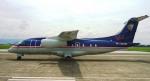
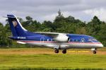
Royal Star Aviation Fairchild Dornier 328 Jet
(Category: FS2004 > Civil Jets)
25.44Mb (4521 downloads)
PREMIER AIRCRAFT DESIGN
Royal Star Aviation Fairchild-Dornier Do328JET for FS2004 (FS9).
A 32 seat twin turbofan regional airliner. All new model with full moving parts, doors with airstair and animated pilots. Accurate and pleasant flight dynamics. Fully modelled interior. Full documentation including manuals and check/ref lists. Custom panel and VC with digital (glass cockpit) gauges. Complete package for FS2004.
Copyright 2010 by Premier Aircraft Design
Email contact: support@premaircraft.com
Model & Master Textures: Jean-Pierre Brisard
Panel design and XML gauge programming Jean-Pierre Brisard
Flight Dynamics Bob May
Royal Star Repaint Gerard G. Olvis
Pushback/taxi speed gauge Rob Barendregt
Multi Function Navigation Dispay Ken Mitchell
Various gauges Steve Southey & Doug Dawson
File packaging & PAD webmaster Bob May
Visit: http://www.royalstaraviation.com.ph/
Royal Star Aviation commercial aircraft (helicopter & fixed wing) charters. They secured their Certificate of Public Conveyance and Necessity from the Civil Aeronautics Board (CAB) on October 6, 1995 and Air Operator Certificate on September 15, 1998. Based in Ninoy Aquino International Airport (RPLL), General Aviation, Pasay City, Philippines.
Posted Oct 25, 2012 03:42 by Gerard G. Olvis
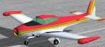
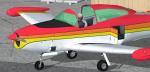
FSX North American Navion Rangemaster red-orange-yellow N7532T Textures
(Category: FSX > Props)
2.95Mb (380 downloads)
FSX North American Navion Rangemaster (not a true Rangemaster
cabin model, but a Navion "B"? canopy/cockpit version with tip tanks).
Red-Orange-Yellow N7532T repaint textures only. For the Schwertfeger-Leaming
(RFS Design) freeware Navion ((Navion_v2.zip), which you must have
previously installed in FSX. Your choice of a 4x3 or widescreen 2D panel
(or fly both), includes a simicon to lower the 2D panel for excellent
over the nose visibility (like the default Skyhawk has), and green tinted
glass. also includes a VC. Screenshots included. Easy Installation.
By Tom Tiedman.
Required files:
required file
Posted Oct 24, 2012 18:47 by Tom Tiedman
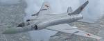
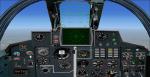
Tupolev Tu-128 Fiddler
(Category: FSX > Military)
11.02Mb (2868 downloads)
I updated Dimitri Samborski and Oleg Tchernikov,s FS2004 Tu-128 Fiddler by adding Jan Moravec's Su-15 2D panel, Aaron R. Swindle,s Skysong Soundworks Soviet Mig-21 Fighter Soundpackage, texture thumbnail, afterburner and sonic boom effects. Has a 2D panel and non working VC.
Posted Oct 24, 2012 09:19 by Michael E. Roberts
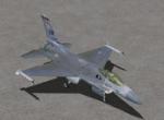
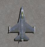
Views 2.0 for the Lockheed Martin F-16 Fighting Falcon
(Category: FSX > Military)
0.12Mb (3251 downloads)
This package contains 2 sets of camera views ( defined by camera definitions in the aircraft.cfg file ) for
the beautiful Lockheed Martin F-16 Fighting Falcon also called Viper by KIRK OLSSON which was
upgraded for FSX by BOB CHICILO.
For easy installation use the "Re-packaged F-16" pack by Soaring Falcon
which includes the Thunderbird version of the F-16.
Version 1.1 is actually based on my original package but with more views and some slight mods
to some parameters.
Version 2.0 is based on version 1.1 but some of the cameras are place at a higher level.
Three new views : top-down zoomable view of the aircraft. 2 VC "Over the shoulder" views.
These views can be added without modifications to the Kirk Olsson's F-16 Thunderbird also upgraded for FSX by Bob Chicilo.
See Read me.txt file for very easy installation procedures.
Camera definitions sets are included in 2 separate text files.
And finally two more files - Available.pdf and Top 20.pdf for informations about my "camera definitions" packages.
Required files:
required file
Posted Oct 23, 2012 21:28 by Marc Renaud
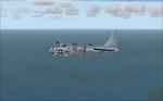
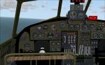
Consolidated PB4Y Privateer
(Category: FSX > Vintage)
20.35Mb (3416 downloads)
Consolidated PB4Y Privateer, 2 liveries, original CFS2-model by Krzysztof Malinowski, now flyable in FSX-Acceleration. Working VC, all necessary gauges included. Enjoy!
Posted Oct 23, 2012 20:54 by erik hertzberger