


All Files > Page 1621
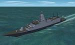
Royal Navy Type 26 Global Combat Ship for CFS2
(Category: CFS2 > Misc)
0.50Mb (409 downloads)
A re-modeled Type 26 Frigate for use in CFS2 as an AI ship. Based on 2012 press release images she is very different to my previous Type 26 release. Fully landable and sinkable. Includes sample mission and SDK (FSDS source files and textures for editing).
Posted Sep 16, 2012 10:39 by Mark Walsh
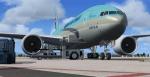

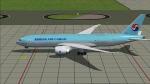
Boeing 777-200LRF Korean Air Cargo Package
(Category: FSX > Civil Jets)
33.63Mb (8257 downloads)
Boeing 777-200LRF General Electric 90-110B1L Korean Air Cargo with VC edited by Danny Garnier to include FSX compatible gauges.
High quality model by Skyspirit/Project Opensky. .
Includes Posky utility to open cargo doors and stairs. (FSX- Views - Instrument panel - Posky_Util)
Thanks to the SkySpirit2010 and Project Opensky team for really great models.
You do so much to promote our great hobby of virtual flying.
Textures by Mathieu Vos
Modified for FSX by Chris Evans.
Posted Sep 16, 2012 09:49 by chris evans
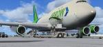
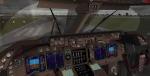
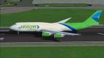
Boeing 747-800 Boeing 747-8F Arrow Cargo with Advanced VC
(Category: FSX > Civil Jets)
34.05Mb (4977 downloads)
Project Opensky - Boeing 747-800 Boeing 747-8F Arrow Cargo for FSX with Advanced VC. Updated aircraft.cfg file to fix takeoff issue.
Assembled and edited for FSX by Chris Evans. Thank you to Skyspirit for their wonderful models. Beautiful BA Air Cargo repaint by Mathieu Vos. With Enhanced VC from Alejandro Rojas Lucenda.
Skyspirit FSX native Boeing 747-8 Cargo model upgraded using the vastly improved Boeing 747 VC from Alejandro Rojas Lucena/FSND (See panel docs for details). VC includes FMC, EICAS, MFD with control panel, GPWS, working wipers, cabin lights, fire suppression, avionics switch, fuel crossfeed, landing lights switches, taxi light switch, engine generators, APU generator, battery switch, starter switches, de-ice switch, general lights switches. Beautiful Skyspirit 747-800 cargo model with complex features and ground service vehicles (press shift e 2, shift e 3, etc. ). To use jetway press Ctrl J.
Also includes the Boeing 747 VC textures upgrade by Jason A. Lee. This give a much clearer 747 interior virtual cockpit look.
Assembled and edited for FSX by Chris Evans.
Zip preview for larger pictures.
See panel docs and images for VC details and controls!
Posted Sep 16, 2012 07:22 by chris evans
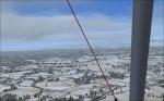
Hokkaido Winter Wonderland!!
(Category: FSX > Missions)
3.40Mb (1505 downloads)
Hokkaido Winter Wonderland (A Fsx Mission!!)
It's a gorgeous day in Hokkaido and you feel like taking your trike flying before meeting family in the local "onsen" (thermal spa)!!
Very good luck to you sir!!
Posted Sep 16, 2012 05:39 by Mr. Pierre G Shlimon
SkySpirit 2011 - Boeing 747-8F Arrow Cargo
(Category: FS2004 > Civil Jets)
18.52Mb (1449 downloads)
SkySpirit 2011 - Boeing 747-8F Arrow Cargo. Model by Project Opensky. Repaint by Mathieu Vos.
Posted Sep 16, 2012 05:10 by Chris Evans
Boeing 777-200LRF Korean Air Cargo
(Category: FS2004 > Civil Jets)
18.66Mb (2815 downloads)
Boeing 777-200LRF General Electric 90-110B1L Korean Air Cargo. Model by Skyspirit. Repaint by Mathieu Vos
Posted Sep 16, 2012 05:07 by Chris Evans
Antonov An-8 Updated Package
(Category: FSX > Props)
32.37Mb (3506 downloads)
I updated Alexander Sklyar's AI Antonov AN-8 to work in FSX.
I added the Samdim An-12 2D panel and sound, along with thumbnail textures. No VC panel.
Posted Sep 16, 2012 02:34 by Michael E. Roberts
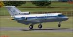
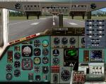
Yakovlev Yak-40 Corporate Updated Package
(Category: FSX > Civil Jets)
19.05Mb (7641 downloads)
I made Yaroslav S. Pankratiev's AI Yak-40 flyable using Philippe WALLAERT's Tu-154 2D panel and FS Audio Team's JT8D sound package.
Included are textures for The Interior Ministry of Russian Federation, The Beriev Design Bureau, The MiG Design Bureau, RusJet, The Sukhoi Design Bureau, and The Yakovlev Design Bureau. Texture thumbnails included. No VC.
Posted Sep 16, 2012 01:08 by Michael E. Roberts
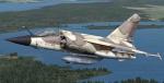
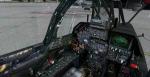
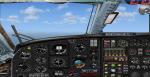
Gmax Mirage F1 Package V2
(Category: FSX > Military)
50.67Mb (20840 downloads)
Gmax Mirage F1 Package V2. Updated with new canopy fixes and VC/panel edits for FSX. This is a Gmax rework of Kirk Olssen payware quality Mirage F1V2.0. It is a complete package with a VC and 2d panel, sounds and With their permission, I've also included the gauges from Romain Lucas and Laurent Lucas's SUPER ETENDARD. There are 4 F1 versions within this package (VR cockpits are all CR models). They are the F1C, F1AZ, F1CR and F1CT. I've added all new textures, a new custom soundset and added many Gmax features to improve realism. One of the major improvements to this plane is the addition of an ALL NEW more realistic looking Virtual cockpit. There are 4 loadout configurations and 4 paint schemes. In the F1C models you can view the entire aircraft from the VRcockpit. Allowing for great Active Camera shots. I've included 3 Active Camera preset files for this purpose.
Thank you to the vast talent of Kirk Olssen and the guys at http://www.mirage4fs.com/
Previous version had 22,000 downloads.
Original FS9 model with panel modified for FSX by Danny Garnier
Posted Sep 15, 2012 15:20 by Garnier D
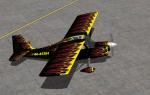
FS2004/FSX LIC Decathlon 'Flames' Textures
(Category: FSX > Props)
1.74Mb (291 downloads)
Textures only for Long Island Classics Decathlon in fictional flames textures. Enjoy and happy flying! works in both fsx and 2004.
Posted Sep 15, 2012 12:47 by Lloyd Horton