


All Files > Page 1623
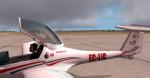
Aerosoft Katana EC-LIC Textures
(Category: FSX > Payware)
11.73Mb (350 downloads)
EC-LIC textures for the payware Aerosoft Katana. Registrations 8203 and 8203 from high-resolution photographs.
Posted Sep 14, 2012 02:33 by Trino Rojas

A Week at Oshkosh Mission Pack
(Category: FSX > Missions)
59.43Mb (5759 downloads)
A week at Oshkosh AirVenture is an 8-mission pack for all Microsoft Flight Simulator X versions, reproducing events at Oskosh Air Ventures 2010. Missions of various difficulty levels will lend you unforgettable enjoyment. The eight missions configure a complete story with loads of effects, sounds, cameras, aircraft, objects, AI, RC models, high-quality scripts, and totally original adventures in the FSX mission world. All missions include rewards and all charts, maps, and diagrams in the original FSX-mission format. For a few hours you will feel like just another participant in Oshkosh AirVenture 2010.
Posted Sep 13, 2012 15:13 by Jose Ariño (Virtual Flight Design )
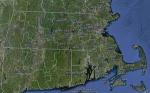
FSX Massachusetts Airfield Locator
(Category: FS Navigation > Flight Simulator Navigation)
2.62Mb (118 downloads)
Tested on Windows XP and Windows 7.
This download adds airfield markers and ICAO id's found in FSX, and overlays them on Google Earth.
This file is for Massachusetts.USA.
There is also a seperate file with a list of basic airfield location details.
i.e: EGBB Birmingham Airport. Birmingham. N52* 27.23' W1* 44.88' alt325.
Also the tidying "My places" in Google Earth, file.
Other locator files to follow.
by Carl Vokes
Posted Sep 13, 2012 15:00 by carl vokes

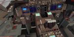
Boeing 747-800F British Airways World Cargo for FSX with Advanced VC
(Category: FSX > Civil Jets)
37.78Mb (5177 downloads)
Project Opensky - Boeing 747-800F British Airways World Cargo for FSX with Advanced VC.
Assembled and edited for FSX by Chris Evans. Thank you to Skyspirit for their wonderful models. Beautiful BA Air Cargo repaint by Mathieu Vos. With Enhanced VC from Alejandro Rojas Lucenda.
Skyspirit FSX native Boeing 747-8 Cargo model upgraded using the vastly improved Boeing 747 VC from Alejandro Rojas Lucena/FSND (See panel docs for details). VC includes FMC, EICAS, MFD with control panel, GPWS, working wipers, cabin lights, fire suppression, avionics switch, fuel crossfeed, landing lights switches, taxi light switch, engine generators, APU generator, battery switch, starter switches, de-ice switch, general lights switches. Beautiful Skyspirit 747-800 cargo model with complex features and ground service vehicles (press shift e 2, shift e 3, etc. ). To use jetway press Ctrl J.
Also includes the Boeing 747 VC textures upgrade by Jason A. Lee. This give a much clearer 747 interior virtual cockpit look.
Assembled and edited for FSX by Chris Evans.
Zip preview for larger pictures.
See panel docs and images for VC details and controls!
Posted Sep 13, 2012 12:03 by chris evans
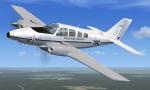
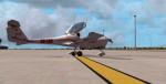
FSX BE-58/UB-58 Uruguay Air Force Texture V2
(Category: FSX > Props)
5.37Mb (672 downloads)
Repaint of the default FSX BE-58 Beechcraft Baron. Corrected textures for the Uruguayan Air Force (Fuerza Aerea Uruguaya-FAU) BE-58/UB-58. The actual aircraft does not have black rubber de-iceing boots on the wings and tail so they have been removed here. The bitmap is also cleaned up to improve the looks. Technical corrections by Enrique Medal Paves. Repainted by R.E. Wyman.
Posted Sep 13, 2012 01:04 by R.E. Wyman
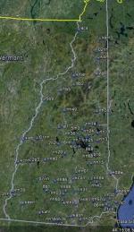
FSX New Hampshire Airfield Locator
(Category: FS Navigation > Flight Simulator Navigation)
2.48Mb (106 downloads)
Tested on Windows XP and Windows 7.
This download adds airfield markers and ICAO id's found in FSX, and overlays them on Google Earth.
This file is for New Hampshire. USA.
There is also a seperate file with a list of basic airfield location details.
i.e: EGBB Birmingham Airport. Birmingham. N52* 27.23' W1* 44.88' alt325.
Also the tidying "My places" in Google Earth, file.
Other locator files to follow.
by Carl Vokes
Posted Sep 12, 2012 21:18 by carl vokes
A2A Airport, Manchester, Vermont
(Category: FSX > Scenery)
0.04Mb (369 downloads)
A2A Airport is a custom airport, set near a lake in Manchester Vermont.
The airport was built with the guys at A2A in mind, and the A2A Community to use for flyins, and get togethers.....
NOTE. This does not by any means, mean that you cannot fly in in what ever aircraft you like to fly.....
Posted Sep 12, 2012 21:13 by Craig Teague
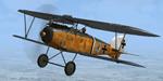
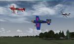
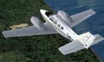
Albatros D.III (Oeffag), The Black Baron Textures
(Category: FSX > Payware)
10.33Mb (334 downloads)
Fictional scheme inspired by the Albatros D.Va replica from The Old Rhinebeck Collection. Note that the Oeffag D.III and Albatros D.Va were completly different planes :)
Posted Sep 12, 2012 20:56 by Lukasz Kubacki
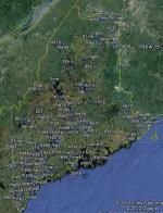
FSX Maine, USA, Airfield Locator
(Category: FS Navigation > Flight Simulator Navigation)
2.50Mb (134 downloads)
Tested on Windows XP and Windows 7.
This download adds airfield markers and ICAO id's found in FSX, and overlays them on Google Earth.
This file is for Maine. USA.
There is also a seperate file with a list of basic airfield location details.
i.e: EGBB Birmingham Airport. Birmingham. N52* 27.23' W1* 44.88' alt325.
Also the tidying "My places" in Google Earth, file.
Other locator files to follow.
by Carl Vokes
Posted Sep 12, 2012 08:34 by carl vokes
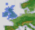
FSX ASTER_imp GDEMv2 30m mesh for British Isles
(Category: FSX > Terrain Mesh)
210.86Mb (4282 downloads)
"imp" means imperfect, as other mesh I have already processed is of areas that have very little vegetation cover - over the land, or has large urban areas.
This "imp" mesh will include some slight discrepancies of altitude (in the case of forested areas - by a magnitude sometimes of +15 metres-depending on how tall the trees are, in the jungle or forest canopy) over urban areas, or areas with a lot of vegetation cover - due to the limitations of the ASTER satellites infra red scanning cameras, and the software used to process the DEM data.
Areas where there is little vegetation cover, or non urban areas, the terrain should have truer values.
But I feel this ASTER DEM data is so good - why let it all go to waste - especially flying over lovely Pacific islands?
So you FSX users out there will have to take all this into account when using this mesh.
Grateful thanks to ERSDAC, and NASA for making this data freely available to the public.
ASTER GDEM
Copyright (c) 2009 - 2011 Earth Remote Sensing Data Analysis Center (ERSDAC) All rights reserved.
ASTER GDEM is a product of METI and NASA.
Posted Sep 12, 2012 05:32 by Wayne Evans