


All Files > Page 1689
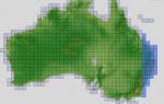
ASTER GDEMv2 30m mesh for Australia Pt1
(Category: FSX > Terrain Mesh)
146.95Mb (640 downloads)
There are Nineteen (19) parts to download for GDEMv2 of Australia.
ASTER GDEM Version 2 is a 30 metre definition DEM, its better than the version 1 data that ERSDAC, of Japan and NASA originally released, but it does have its limitations.
GDEM has been obtained from a satellite that uses stereoscopic infrared scanning cameras, this brings with it problems in the resultant data.....where it sees the tops of trees, buildings etc, as the ground terrain.
If you look at the jpg image with the terrain type errors shown as a graph, you will see that the only 'safe' terrain to use this data with - in FSX - is scrubland, or desert terrain.
Its hopeless in defining the terrain in places like Europe - with all the artificial structures, (buildings) and different types of woodland, so any mesh I create from this data won't include areas like that....it will be more desert type terrain, and scrubland.
I won't be doing Greenland because something about the ice around Greenland, (or any other land mass with ice) it creates false data.
It does give enough fine data to reveal railway lines, and some roads though.
This mesh has been made for FSX only.
Grateful thanks to ERSDAC, and NASA for making this data freely available to the public.
ASTER GDEM
Copyright (c) 2009 - 2011 Earth Remote Sensing Data Analysis Center (ERSDAC) All rights reserved.
ASTER GDEM is a product of METI and NASA.
Posted Jun 1, 2012 02:53 by Wayne Evans
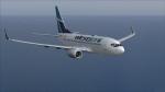
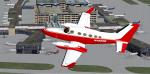
FS2004 Westjet 737 Pack
(Category: FS2004 > Civil Jets)
32.83Mb (4788 downloads)
This pack comes with all four Westjet 737s: 737-600, 737-700 with winglets, 737-800 with winglets and the 737-800 Care-Antee livery. All come with panels, wing views, sound, altitude callouts and of course, textures and models. Models by Project Open Sky. Sound pack by Kriss Armstrong recommended.
Posted May 31, 2012 23:25 by Ryan Klatt
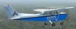
VFR Prop Hops Textures Pack 1
(Category: FSX > Props)
114.87Mb (461 downloads)
This package has a total of 13 texturs for various aircraft in FSX - default and downloadable. for the Virtual aviation group Vfr Prop Hops. We fly general aviation aircraft in group flights and special events on the VAT ME Server - http://www.vatmegroup.com/newsite/ See our website at www.vfrprophops.com - contact us at vfrprophops@gmail.com. We want all pilots who want to do real general aviation simulation. We follow FAA rules for VFR flight but we also use ILS approaches and other instrument flying. Flight plans are available in our personal TeamSpeak channel - sign up with us at www.vfrprophops.com for more information.
Posted May 31, 2012 16:42 by Vfr Prop Hops
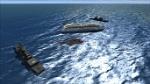
English Channel Rescue Scenery
(Category: FSX > Scenery)
0.00Mb (1446 downloads)
A ship is disabled in the English channel (between France and UK) Two navy ships are there to assist. Fly south from Manston in a chopper and bring survivors home.
Posted May 31, 2012 16:09 by petejg5

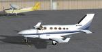
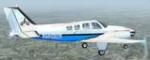
FSX Cessna 414A Chancellor blue and white N749W Textures
(Category: FSX > Props)
1.61Mb (1107 downloads)
An FSX blue and white N749W repaint texture for the Premier Aircraft Design
Cessna 414A Chancellor, which you must have previously installed in FSX.
Easy installation, screenshots enclosed. Repaint by Tom Tiedman.
Required files:
required file
Posted May 31, 2012 04:47 by Tom Tiedman

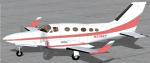
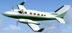
FSX Cessna 414A Chancellor red and white N4869R Textures
(Category: FSX > Props)
2.06Mb (1048 downloads)
An FSX red and white N4869R repaint texture for the Premier Aircraft Design
Cessna 414A Chancellor, which you must have previously installed in FSX.
Easy installation, screenshots enclosed. Repaint by Tom Tiedman.
Required files:
required file
Posted May 31, 2012 04:45 by Tom Tiedman
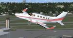
FSX Cessna 414A Chancellor pink, gray, and white N3768T Textures
(Category: FSX > Props)
1.70Mb (341 downloads)
An FSX pink, gray, and white N3768T repaint texture for the Premier Aircraft Design
Cessna 414A Chancellor, which you must have previously installed in FSX.
Easy installation, screenshots enclosed. Repaint by Tom Tiedman.
Required files:
required file
Posted May 31, 2012 04:42 by Tom Tiedman
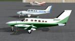
FSX Cessna 414A Chancellor green and white N7435Y Textures
(Category: FSX > Props)
1.54Mb (612 downloads)
An FSX green and white N7435Y repaint texture for the Premier Aircraft Design
Cessna 414A Chancellor, which you must have previously installed in FSX.
Easy installation, screenshots enclosed. Repaint by Tom Tiedman.
Required files:
required file
Posted May 31, 2012 04:40 by Tom Tiedman


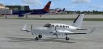
FSX Cessna 414A Chancellor red and white N7692J Texture
(Category: FSX > Props)
1.47Mb (534 downloads)
An FSX red and white N7692J repaint texture for the Premier Aircraft Design
Cessna 414A Chancellor, which you must have previously installed in FSX.
Easy installation, screenshots enclosed. Repaint by Tom Tiedman.
Required files:
required file
Posted May 31, 2012 04:38 by Tom Tiedman

FSX Cessna 414A Chancellor blank white Textures
(Category: FSX > Props)
1.50Mb (449 downloads)
An FSX blank white paintable repaint texture for the Premier Aircraft Design
Cessna 414A Chancellor, which you must have previously installed in FSX.
Easy installation, screenshots enclosed. Repaint by Tom Tiedman.
Required files:
required file
Posted May 31, 2012 04:34 by Tom Tiedman