


All Files > Page 1690

Quantas and ANA Color Schemes Boeing 747-400 Package
(Category: FSX > Civil Jets)
80.09Mb (3647 downloads)
I have converted some repaints made by Xudeva Irribarra for POSKY 747-4x series. However I were unable to find a proper aircraft that can work with FSX 747 original VC, so I took the winglet version of 747-400, and converted three awesome repaints to work with this aircraft.
This package contains: Quantas Wunala Dreaming, All Nippon Airways Ohana Jumbo Blue Winglets, All Nippon Airways Ohana Jumbo Grey Winglets. Package comes with 2D panel and VC in three colours (Grey, Blue and Brown). There is a small glitch with VC ligtning. Read 'Read Me' file for solution.I have converted some repaints made by Xudeva Irribarra for POSKY 747-4x series. However I were unable to find a proper aircraft that can work with FSX 747 original VC, so I took the winglet version of 747-400, and converted three awesome repaints to work with this aircraft.
Posted May 28, 2012 18:23 by Eggtooth
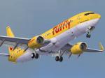
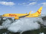
TUIfly Boeing 737-8K5 D-AHFV Textures
(Category: FS2004 > Payware)
10.57Mb (1459 downloads)
Boeing 737-8K5,(cn 30415/719), registration D-AHFV. TUIfly is the third bigger airline in Germany, wearing this very nice yellow livery. Textures only for the iFly 737-800 (payware package) model.
By Juan Ernesto Oropeza.
Posted May 28, 2012 17:32 by Juan Ernesto Oropeza
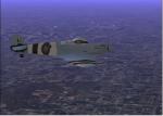
CFS1 Spitfire RAF Blue textures
(Category: CFS1 > Aircraft)
0.31Mb (168 downloads)
Here is a Blue Spitfire, Textures Only. Simply install the new textures. Made with Adobe Photoshop.
Posted May 28, 2012 14:59 by Howard Abilas
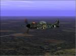
Fw190A Camouflage Textures
(Category: CFS1 > Aircraft)
0.13Mb (139 downloads)
Here is a green camouflage FW190A. Textures Only. Simply install the new textures. Made with Adobe Photoshop.
Posted May 28, 2012 14:55 by Howard Abilas

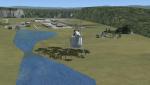
Vietnam Military Major Airport
(Category: FSX > Scenery)
1.57Mb (609 downloads)
Vietnam Military Major Airport. Fictional. Does not exist in real life. Created as a fun fictional place to fly.
Posted May 28, 2012 11:25 by Martin
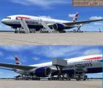
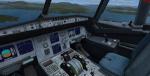
British Airways Boeing 777-200ER Package
(Category: FSX > Civil Jets)
32.96Mb (13119 downloads)
British Airways Boeing 777-200ER BA G-YMMD livery painted on Project Opensky's Boeing 777-200 VC model.
The textures are saved in 32bit format for quality graphics.
Includes VC edited by Danny Garnier.
Wonderful Boeing 777-200ER Trent VC model by Project Opensky.
Includes ground services (Views - Instrument Panel - Posky Utilities).
Textures by Daniel Alamilla.
Happy Flying!
Updated for FSX by Chris Evans
Posted May 28, 2012 08:42 by Chris Evans
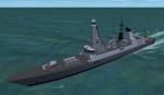
Royal Navy Type 45 (HMS Daring) Model Update
(Category: CFS2 > Misc)
0.04Mb (418 downloads)
A replacement model file for my Type 45 destroyer (RN_Type_45.zip) which corrects some of the texture mapping and transparency (or lack of) issues. It also updates/improves a few minor details.
Posted May 27, 2012 10:52 by Mark Walsh
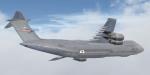

Area 51 C-5M Super Galaxy Textures
(Category: FSX > Payware)
2.70Mb (1253 downloads)
This is a repaint of the Area 51 Simulations C-5M Super Galaxy. This aircraft represents aircraft 90014, assigned to the 433d Airbase Wing at Lackland AFB, Kelly Field Annex.
Posted May 27, 2012 10:13 by KiltinSA

FSX Wizz Air A320-232
(Category: FSX > Civil Jets)
16.58Mb (7425 downloads)
FSX Wizz Air A320-232 IAE. A repaint of Project Airbus A320-200 IAE model in the colors of Wizz Air, registration HA-LPT. Coupled to the default A321 VC. Repainted by: Mohammed Al-Khalifa.
Posted May 27, 2012 06:36 by uploader
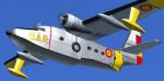
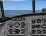
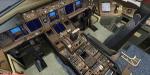
FS2004/FSX Texture & FSX Panel GRUMMAN HU-16 ALBATROS Spanish Air Force
(Category: FSX > Props)
5.61Mb (1330 downloads)
Livery of the HU-16 Spanish Air Army. It's an old texture adapted to the new version HU-16 Albatross FS2004/FSX (required) by Greg Pepper and Michael Verlin. I also include another FSX update for the panel, using original FSX gauges.
Required files:
required file
Posted May 27, 2012 05:38 by Enrique Medal