


All Files > Page 1696
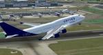
United Charter Boeing 747-400
(Category: FS2004 > Civil Jets)
12.09Mb (1810 downloads)
FS2004 United Charter Boeing 747-400. Registration N194UA. Model by Project Open Sky.
Posted May 21, 2012 06:24 by uploader
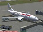
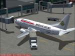
"Republica de Costa Rica" 737-300
(Category: FS2004 > Civil Jets)
1.42Mb (811 downloads)
"Republica de Costa Rica" 737-300. Model by Vistaliners.
Posted May 20, 2012 20:16 by Alberto Thomas
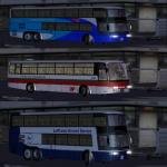
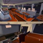
Driveable Airport Bus
(Category: FSX > Misc)
3.35Mb (14382 downloads)
Hama 1000 / 1001 Airport bus, improve movements and extra textures ( Lufthansa, Tap Portugal, Paintkit, Airport Ground Service ).
Includes driving cabin & interior. Made by Mitsuya Hamaguchi. Textures by ricardo_tv.
Posted May 20, 2012 18:59 by ricardo_tv
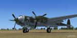
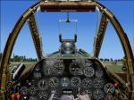
P-38 Fear The Reaper
(Category: FSX > Vintage)
13.93Mb (11633 downloads)
This is David C. Copley's P-38 Lightning Updated for Microsoft Flight Simulator X . This Aircraft Carries The Grim Reaper into Battle " Fear The Reaper " . This aircraft includes a 2D panel by Mel Mutter. VC/3D panel edited by RDG Aircraft works in FSX. Also included is War Emergency power effect. Updates and Textures By Mark " Fireball " Rooks of RDG Aircraft.
Posted May 20, 2012 18:07 by Mark Fireball Rooks
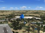
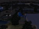
Fictional Resort in South Africa
(Category: FSX > Scenery)
0.56Mb (429 downloads)
Fictional Resort in South Africa. After installing into FSX look for airport id: SSWP. Zip preview for more pics.
Posted May 20, 2012 17:59 by Martin
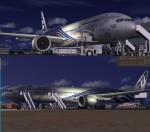
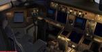
Boeing 777-300ER Experimental House Livery Package
(Category: FSX > Civil Jets)
55.25Mb (7146 downloads)
Boeing 777-346/ER N5017V. Boeing Experimental 777-300ER House livery. Painted on Project Opensky's Boeing 777-300 aircraft.
The textures are saved in 32bit format for quality graphics.
Includes VC edited by Danny Garnier. Real Boeing 777 sounds.
Wonderful Boeing 777-300ER GE VC model by Project Opensky.
Includes ground service (Views - Instrument Panel - Posky Utilities).
Textures by Abdullah Rahman.
Happy Flying!
Updated for FSX by Chris Evans
Posted May 20, 2012 16:25 by Chris Evans
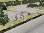
Namibia Oasis Landing Spot
(Category: FSX > Scenery)
0.00Mb (394 downloads)
THIS is a really relaxing place to land when you
are flying in the desert, and need a refreshment and to refill your plane!! It is situated in Namibia. Namibia in Africa. Look for airport ID: DONM. Happy Flying!!
Posted May 20, 2012 13:56 by Martin
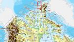
FSX Canadian CDED mesh above 60 degrees Lat 19 metre resolution Pt49, block 560. THIS IS THE LAST PART.
(Category: FSX > Terrain Mesh)
57.80Mb (430 downloads)
As Raimondo Taburet hasn't processed the CDED files above 60 degrees latitude for Canada, well here are the ones I have processed.
There isn't any data available from geobase in some of the blocks above 60 degrees latitude, these are blocks: 15, 17, 18, 28, 108, 109, 118, 119.
See jpg for coverage.
Thanks go to Geobase (Copyright) Canada for the availability & public use of this data.
Posted May 20, 2012 06:48 by Wayne Evans
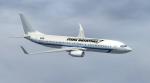
Stark Industries Business Jet Boeing 737-800 Textures
(Category: FSX > Civil Jets)
3.11Mb (1165 downloads)
Boeing 737-800 Stark Industries Business Jet textures for the default Boeing 737-800. Inspired by Stark Industries, a fictional defense and aeronautics technologies company created by Marvel comics, well-known from Iron Man comics and movies.
Posted May 20, 2012 05:45 by Luthfan Auzan Ramadhana
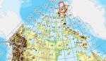
FSX Canadian CDED mesh above 60 degrees Lat 19 metre resolution Pt48, block 340.
(Category: FSX > Terrain Mesh)
235.92Mb (391 downloads)
As Raimondo Taburet hasn't processed the CDED files above 60 degrees latitude for Canada, well here are the ones I have processed.
There isn't any data available from geobase in some of the blocks above 60 degrees latitude, these are blocks: 15, 17, 18, 28, 108, 109, 118, 119.
See jpg for coverage.
Thanks go to Geobase (Copyright) Canada for the availability & public use of this data.
Posted May 20, 2012 05:29 by Wayne Evans