


All Files > Page 1706
STS Guidance MFD for Orbiter 2010
(Category: Space Orbiter > Orbiter Addons)
5.60Mb (2393 downloads)
This is the original package for the guidance MFD originally developed by R J Croy back in 2003. I have updated the software to work with Orbiter 2010 patch 1, and the new files are included. Please read the original documentation for usage. Remember to include the line "OMS" in the scenario file to use this with the Shuttle Fleet. The usage documentation is included in the Soyuz Guidance MFD.
Posted May 11, 2012 21:29 by David413
Soyuz Guidance MFD for Orbiter 2010
(Category: Space Orbiter > Orbiter Addons)
5.62Mb (1606 downloads)
This is the original package for the guidance MFD originally developed by R J Croy back in 2003. I have updated the software to work with Orbiter 2010 patch 1, and the new files are included. Please read the original documentation for usage.
Posted May 11, 2012 21:26 by David413
Heliports in Costa Rica
(Category: FS2004 > Scenery)
1.52Mb (222 downloads)
Package of heliports in Costa Rica. FS2004
Posted May 11, 2012 21:02 by Alberto Thomas - Costa Rica

Ancient Machines
(Category: FSX > Missions)
20.07Mb (2377 downloads)
The Prime Minister has ordered for you to fly Dr. Sing and his party to a Chinese Village beyond the mountains. There you will listen to the oldest Lama and proceed accordingly. ...This is a super secret Mission without the authorization to use Chinese air space. If you fly higher than indicated their radar will pick you out and a missile will sure hit you so fast you will not know what happened. Very little instructions have been provided to you by the air authorities so you must use your "detective" instincts to be successful in this quest. Obviously a very hard Mission for experienced pilots and connoisseurs of foggy situations (?). For use with a good turbo prob aircraft .....Yang ping kung go pu!!!
Posted May 11, 2012 16:54 by Gera Godoy Canova
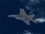
VRS Superbug VMFAT_101 CAGSH 200 Textures
(Category: FSX > Payware)
2.67Mb (380 downloads)
Sharpshooters CAG textures only for the payware VRS Superbug.
Posted May 11, 2012 05:24 by Chris Hammons
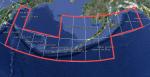
CGIAR-CSI v4.1 90 metre SRTM mesh for Aleutian Islands (Alaska)
(Category: FSX > Terrain Mesh)
26.86Mb (1086 downloads)
This version of the NASA SRTM DEM data, processed by the people at CGIAR-CSI, Kings College, London - is a considerable improvement on previous versions.
It is considered to be the highest quality SRTM 90m dataset available.
So I thought it would be a good idea to process it, so you FSX users out there could use it.
Citation:
Thanks to NASA, and CGIAR-CSI Kings College, London, UK.
Void-filled seamless SRTM data V1 (Now v4.1), 2004, International Centre for Tropical Agriculture (CIAT), available from the CGIAR-CSI SRTM 90m Database: http://srtm.csi.cgiar.org and http://www.ambiotek.com/topoview
Posted May 11, 2012 04:40 by Wayne Evans
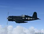

Battle Worn Chance Vought F4U-7 Corsair
(Category: FSX > Vintage)
14.40Mb (6168 downloads)
This is a Repaint of Guy Hulin's Corsair Updated For Flight Simulator x. This aircraft is the Corsair flown by The United States Navy during WW2 shown here with battle worn texture. This Aircraft has a 2D and 3D Cockpit New Textures, War Emergency Power, Exhaust Flames, Exhaust plume, Folding wings, Tail hook, and FSX updates by Mark Rooks of RDG Aircraft. History and pictures included in this PKG.
Posted May 10, 2012 23:48 by Mark Fireball Rooks
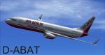

Boeing 737-800 AirBerlin Textures
(Category: FSX > Civil Jets)
10.42Mb (2579 downloads)
Air Berlin textures for the default Boeing 737-800 FSX
Posted May 10, 2012 18:20 by Jim Fly
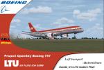
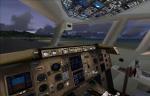
LTU Fleet - Boeing 757-200
(Category: FSX > Civil Jets)
23.08Mb (5283 downloads)
LTU, now operating as Air Berlin, was a popular German budget airline, and flew many type of aircraft including McDonnell, Boeing, Airbus. This
Boeing B757-200 by Project Opensky.
VC edit and textures by ricardo_tv
Have fun
Posted May 10, 2012 17:57 by ricardo_tv
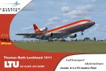
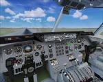
LTU Fleet - L-1011
(Category: FSX > Civil Jets)
26.67Mb (6085 downloads)
LTU, now operating as Air Berlin, was a popular German budget airline, and flew many type of aircraft including McDonnell, Boeing, Airbus. This Lockheed L-1011 by Thomas Ruth. VC edited and textures by ricardo_tv Have fun
Posted May 10, 2012 17:52 by ricardo_tv