


All Files > Page 1924
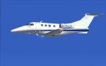
Embraer Phenom 100
(Category: FS2004 > Civil Jets)
2.35Mb (3340 downloads)
FS2004 N784JP, Embraer Phenom 100 by CamSim, including exterior Animated Ground Servicing (AGS)
and special interior animations and configuration: 4 passengers in seating position
and 1 passenger who will stand up and walk back and forth in the cabin and return to is "seating position", plus pilot and co-pilot moving arms. For these animations press (Shift+E+2).
Model design and paint: Camil Valiquette
Posted Aug 3, 2011 11:34 by Camil Valiquette
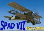
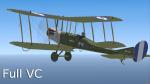
FS2004 SPAD VII Hellenic Army Package
(Category: FS2004 > Vintage)
8.30Mb (1730 downloads)
FS2004 Hellenic Army Air Sevice (STRATIOTIKH AEROPIKH YPHRESIA)Spad VII Package.
The SPAD S.VII was in action during WWI with 16 aircraft of the Hellenic Army Air Service operating
with the Greek/ French Sqadrons and during the Asia Minor Campain as a Fighter.
This is a complete package with full VC and 2d panel and gages, effects and Sound.
Many thanks to Stuart Green for this outstanding freeware model. Repaint for the Hellenic colors by: Yiannis Katehis Tsetsas.
Posted Aug 2, 2011 13:50 by YIANNIS KATEHIS TSETSAS
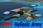
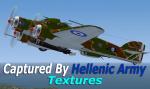
FS2004 Royal Aircr aft Co.BE2c Hellenic Navy Textures
(Category: FS2004 > Vintage)
2.13Mb (501 downloads)
This is the Hellenic Naval Air Service (NAYTIKH AEROPORIKH YPHRESIA N.A.Y.)Royal SB2c #8414 (IKARIA) that served the Hellenic Royal Navy (VASILIKO NAYTIKO) from 1919-1922. Early reconnniassence aircraft that was in action during WW1 In The Asia Minor Campain as a Recognizer. It also had a trainer role for the Hellenic Navy.
You will need the Edward Cooks Freeware model rafbe2v2 zip for this that can be found at Simviation 2004 Vintage page.
The model has moving parts full VC and 2D Panel and gages
The Repaint on the Hellenic colors was done by YIANNIS KATEHIS TSETSAS
Required files:
required file
Posted Aug 2, 2011 13:41 by YIANNIS KATEHIS TSETSAS
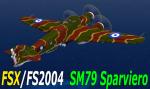
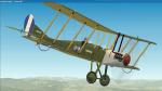
FSX / 2004 SM79 Hellenic Air Force Captured Package
(Category: FSX > Vintage)
3.93Mb (1755 downloads)
FSX/FS2004"Savoia Marchetti S.79 Sparviero (Sparrow Hawk) Package.Thanks to Kazunori Itos Freeware
SM79model. One of the most famous Italian aircraft of WWII". This aircraft repaint represents an actual Sparviero of the 254aSquadriglia of the 105th "Gruppo Autonomo BT "(Autonomus Bombardment Group) of "Comando Aeronautica Albania" that was captured by the Hellenic Army after the occupation of “Argirocasto” and “Koritsa” in 1940. It served with the Royal Hellenic Air Force as a transporter. The Greeks having their hands full with the war in progress, didn't even bother to erase the Italian Air Force markings. Instead they just put the Hellenic markings right over the old numbers. This aircraft was flying and was regulary serviced during the entire Hellenic war effords in Albania and it was seen in several airfields including Tatoi Air Base during the war .This is a complete package. Model Gauges Conf. and 2d Panel by Kazunori Ito. Repaint for the Hellenic colors by:Yiannis Katehis Tsetsas. (No VC)
Posted Aug 2, 2011 13:10 by YIANNIS KATEHIS TSETSAS
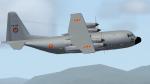
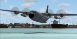
FS2004/FSX Belgian Air Force C130 CH-08 Textures
(Category: FS2004 > Military)
4.02Mb (2088 downloads)
This is a repaint of the Belgian C130 serial CH-08 No. 20sqn / No. 15Wing.
They are used for air transport and other heavy things, ...
This is textures only and
you required the "FS2004 SimShed C130 Royal Danish Air Force package".
Enjoy your flight with this great aircraft.
Posted Aug 2, 2011 06:15 by Jonathan Linart
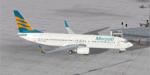
Boeing 737-800 Merpati Nusantara Airlines Textures
(Category: FSX > Civil Jets)
3.16Mb (2206 downloads)
Boeing 737-800 Merpati Nusantara Airlines textures for the default FSX 737. Merpati Nusantara Airlines is an airline based in Central Jakarta, Jakarta, Indonesia. It is a major domestic airline operating scheduled services to more than 25 destinations in Indonesia, as well as scheduled international services to East Timor and Malaysia. Its main base is Soekarno-Hatta International Airport, Jakarta
Posted Aug 2, 2011 03:03 by muhamad didi muchtar
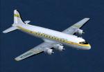
FSX/FS2004 DC-4 Panagra Textures
(Category: FSX > Vintage)
2.96Mb (507 downloads)
FSX/FS2004 Panagra textures for the JBK DC-4-1009 V.3 by Jens Kristensen. These textures represent Panagra's livery for the DC-4 about 1951.
Textures by Gary Harper.
Required files:
required file
Posted Aug 1, 2011 23:26 by Gary Harper
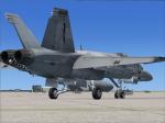
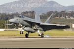
VRS Superbug NSAWC 114 ona Line Textures
(Category: FSX > Payware)
2.43Mb (643 downloads)
VRS Superbug NSAWC 114 CONA LINE textures.
Requires the payware VRS Superbug
repaint By Hornet202 Enjoy
Posted Aug 1, 2011 21:29 by Chris Hammons
-1.jpg-thumb.jpg)
.jpg-thumb.jpg)
Set of Three FSX VFR Low Altitude Flight Plans
(Category: FS Navigation > Flight Simulator Navigation)
4.78Mb (422 downloads)
Set of three VFR Low Altitude Flight Plans in Florida, Australia, and South Korea. Installation and Usage instructions are inside each individual folder. These are great routes for B-52, F-111, B-1B, B-2 A6, A4, Vulcan and any fighter or bomber enthusiasts. Of course you can fly the routes with any aircraft of your choice. Included in this package are two spectacular gauges by Karol Chlebowski for TFR flying and Pave Tack which includes many advanced features for bombing, navigation and reconnaissance. These two gauges will greatly enhance your ability to fly these challenging routes and are a great companion of the flight plans. Another option to download Version 2.1 of my mini panel which has all this functionality and more.
Posted Aug 1, 2011 10:27 by Bill McClellan
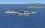
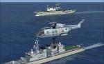
FSX(A) HMCS True North Battlegroup
(Category: FSX > Military)
8.59Mb (3739 downloads)
A logical follow on to the Majestic CVL, the incomplete HMS Audacious was purchased by the RCN and completed
to Ark Royal's standard. A repaint for the Flying Stations FSX HMS Ark Royal as HMCS True North, 2 repaints for
Hama's FSX Coast Guard ship and DDG Hamagiri as a hypothetical 'River' class DDG and a Patrol-Training Frigate
of the 'Town' class, a simple repaint of the Default Acceleration EH-101 in RCN utility marks, and a simple repaint
for the simple AI NH-90 by JP Baril as a plane guard helio A home afloat for FSX Royal Canadian Navy operations.
For use with FSX Acceleration and the AICarriers utillities
Posted Aug 1, 2011 09:34 by AI Retro Carrier Group