


All Files > Page 2190
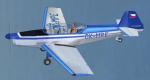
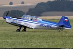
FSX/FS2004 OK-MPE Zlin Z-226MS Textures
(Category: FSX > Props)
2.20Mb (695 downloads)
Zlin Z - 226 MS JE Jediny Motor , DVA textures for
Z 226MS OK - MPE v Aero Club v Chrudimi - Eeska Republika Requires the full Zlin Z-226MS model.
Required files:
required file
Posted Aug 20, 2010 09:24 by Jozef Košík
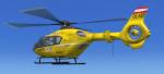
FSX EC135 OEMTC OE-XEP Austrian SAR Textures
(Category: FSX > Helicopters)
0.97Mb (4323 downloads)
This are Textures only, for Heiko Richters EC135.
Tested FSX SP1+SP2, not FS2004 but should work.
Repaint by Sandro Kumric (RaceOfficer)
Posted Aug 20, 2010 07:51 by Sandro Kumric (RaceOfficer)
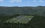
Virginia Mountains Airport Scenery
(Category: FSX > Scenery)
0.43Mb (906 downloads)
FSX Virginia Mountains Airport Scenery. Number 5 in the series of Pro Hop fictional airports. These are small mountain airports in the Virginia (VA) and North Carolina (NC) Smokey Mountains. They add some eye candy at the airports to make it more fun. Created by J. D. Starseed.
Posted Aug 20, 2010 07:13 by J. D. Starseed
FS2004
S-3B Viking Package
(Category: FS2004 > Military)
17.88Mb (13886 downloads)
FS2004
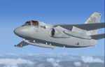
S-3B Viking Package.
The S-3B Viking provides multimission support to battle group
and joint commanders in the antisurface, antisubmarine, electronic
surveillance, overland strike support, mine warfare, and aerial
refueling roles. The ES-3A Shadow is carrier aviation's principal
signals intelligence (SIGINT) reconnaissance aircraft. This
electronic reconnaissance aircraft supports all facets of Navy,
Marine Corps, and joint operations. As one of carrier aviation's
newest additions, the ES-3A has already demonstrated tremendous
reliability and safety, as well as a robust mission capability.
Note: Gauges are not compatible with FSX. The aircraft will
show but with missing gauges. Ex payware. Not supported. By
Iris with sounds by Aaron Swindle. 17.9MB
Posted Aug 20, 2010 05:35 by archive
FS2004
Northrop YB-49 Flying Wing V2
(Category: FS2004 > Military)
2.61Mb (5786 downloads)
FS2004
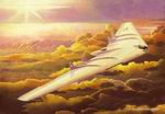
Northrop YB-49 Flying Wing V2.
Thanks for downloading version 2 of my YB49 Flying wing This
Aircraft is very similar to my YRB-49 model, but has a different
engine layout (The YB has eight engines in the wing) and also
a canopy on the rear fuselage. Both the YRB and YB aircraft
were included in a single file on version 1, however version
2 is more complex so i have separated them into 2 separate files
to keep the file size down. Panel is same as Version 1 had,
but with the addition of a digital trim gauge, all the other
Gauges are either standard FS2004 or P51D gauges from CFS (included
in the file). J Higgs. 2.6MB
Posted Aug 20, 2010 05:35 by archive
FS2004
B-2A Bomber Update
(Category: FS2004 > Military)
0.03Mb (4542 downloads)
FS2004
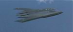
B-2A Bomber Update.
This is an update for FS 9 of the B-2A Bomber Package by RUGGERO
OSTO (here).
I have updated the flight dynamics, put in all the wheels, and
changed the view angle slightly to better see over the nose.Bob
Chicilo. 28K
Posted Aug 20, 2010 05:35 by archive
FS2004
CASA/EADS CN235 Textures only.
(Category: FS2004 > Military)
0.60Mb (2068 downloads)
FS2004
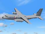
CASA/EADS CN235 Textures only.
Light Transport aircraft used by many nations around the world
including the Ejercito del Aire. Textures only. Original CN-235
aircraft by Rancho_JEN required here,
repaint by Justyn "Planejunky" Keeble. 617K
Posted Aug 20, 2010 05:35 by archive
FS2004
USAF KC-30A Textures only.
(Category: FS2004 > Military)
3.76Mb (2646 downloads)
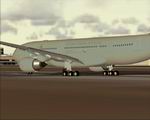
FS2004
USAF KC-30A Textures only.
Northrop Grumman/Airbus KC-30A Advanced Multi-Role Tanker Transport.
The Northrop Grumman KC-30 is based on the highly successful
A330-200 airliner, and is a derivative of the tanker/transport
aircraft already selected for service in the air forces of Australia
and the United Kingdom. The KC-30 provides a total air mobility
solution – with exceptional capacity for in-flight refueling,
plus full flexibility in cargo delivery, passenger transport,
aeromedical evacuation, and other missions. Base Aircraft: POSKY
Airbus A330-200 (required here)
Repaint by Ryan Pearce. 3.8MB
Posted Aug 20, 2010 05:35 by archive
FS2004
YF-22 Raptor Mobius 1 Textures only
(Category: FS2004 > Military)
1.28Mb (2120 downloads)
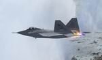
FS2004
YF-22 Raptor Mobius 1 Textures only.
A Repaint of the Iris YF-22 (required above)in the colours of
Mobious 1 from the Ace Combat Series. By Jon Rose. 1.3MB
Posted Aug 20, 2010 05:35 by archive
FS2004 C-119 Boxcar Update.
(Category: FS2004 > Military)
0.08Mb (1774 downloads)
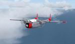
FS2004
C-119 Boxcar Update. This
is an update for FS 9 of the C-119 Boxcar by Mike Stone (here).
I have added the rest of the wheels, updated the flight dynamics,
added toggle icons to the panel, changed the GPS, and changed
the view angle to make it easier to see to land. Bob Chicilo.
81K
Required files:
required file
Posted Aug 20, 2010 05:35 by archive