


All Files > Page 3088
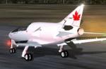
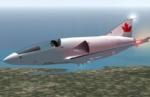
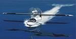
FS2004 HD - 1 Swift
(Category: FS2004 > Civil Jets)
0.92Mb (6336 downloads)
HD - 1 Swift. The result of bored stiff engineers asking “How big a jet engine can you strap to your ass?”
Improved landing gear and landing performance since last build. New dynamic 3D virtual cockpit and 2D instrument panel. More texture mapping completed. Plus the standard stuff like the 14ft wing span; 16ft fuselage; Mach 1.8; 3700lb thrust jet; animatedreverse thrust, animated dual slotted fowler flaps and slats. animated speed brakes and spoilers, animated trailing link landing gear with dual wheels and nose steering.
More information:
http://www.dickert.ca/swift
Posted Jan 8, 2009 02:09 by Harold Dickert
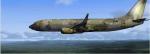
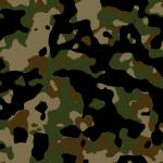
FSX Boeing 737-800 Camo Textures
(Category: FSX > Military)
1.34Mb (9793 downloads)
Boeing 737-800 woodland Camo Textures for the default 737. Textures by Mike Barton.
Posted Jan 7, 2009 19:10 by Mike Barton
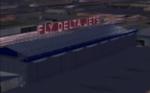
Atlanta Int Delta Air Lines "Fly Delta Jets" Hangar
(Category: FSX > Scenery)
1.67Mb (3039 downloads)
This is a detailed gmax model of the Delta Air Lines "Fly Delta Jets" Hangar located at the Atlanta Int. Airport (KATL).
Posted Jan 7, 2009 18:22 by Tyler Newport
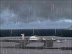
FSX Svalbard/Spitzbergen Airports, Norway (Near North-Pole)
(Category: FSX > Scenery)
0.47Mb (2809 downloads)
These airports are with more detail than the FSX standard airports.
This Svalbard/Spitzbergen package consists of two airports. ENSB is the Svalbard Longyear airport. It is only a
correction/update of the Standard FSX with buildings and aprons but with more objects (marina, radar station,
buildings and cars). EN67 is a little small runway called Broggerhalvoya airport. Near EN67 I placed also some
additional objects like a marina, observatory, lakes and a small research station (=town Ny-Alesund).
Design by Bernhard W.
Posted Jan 7, 2009 17:54 by Bernhard W.
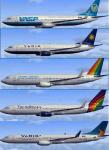
FSX Jetliner Brazilian Airlines textures
(Category: FSX > Civil Jets)
49.49Mb (6445 downloads)
Brazilian Airlines textures for the FSX default Boeing 737-800 , Boeing 747-400 , Airbus a321.
Posted Jan 7, 2009 16:10 by michel
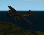
Dornier Seastar Update for FSX
(Category: FSX > Props)
0.48Mb (4357 downloads)
This is an update for FSX acceleration of the
Dornier Seastar by Mike Stone. I have
updated the flight dynamics so it works in
FSX. This is the whole aircraft. No virtual
cockpit.
Bob Chicilo.
Posted Jan 7, 2009 09:22 by Bob Chicilo
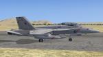
FSX Acceleration VFA-102 Textures
(Category: FSX > Military)
3.79Mb (2314 downloads)
VFA-102 FA18 Textures only for the FSX Accelleration default FA18
Posted Jan 7, 2009 06:39 by FSXF Rhino
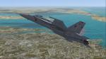
FSX Acceleration FA-18 Hornet VFA-102 Textures
(Category: FSX > Military)
1.96Mb (2059 downloads)
FA-18 Hornet VFA-102 Textures only for the FSX Acceleration default FA18
Posted Jan 7, 2009 06:29 by FSXF Rhino
Dornier Do-17z-10 Kaus II FuG 202
(Category: CFS2 > Aircraft)
4.18Mb (1079 downloads)
The Dornier Do17z-10 Kaus II Night Fighter Telefunken FuG 202 Radar.The last few production Do-17z were made as Night Fighters. The glazed nose was removed and replaced with a custom built solid one.
The armament was upgraded over the Kaus I, and the crew could reload the 20 mm cannons internally. This Z-10 was equipt with the Telefunken FuG 202 Radar detection system.
Extra range was by placing fuel tanks in the bomb bay. Only nine Z-10s were completed and served for less than two years in the night fighter role, where it was used in Josef Kammhuber's defensive system,
known as the Kammhuber Line. Only one Z-10 was fitted with this radar. The skin is of R4 AK 2./NJG 2 Model file, airfile, DP, and textures by Thicko. Panel by Lobo de Silva. Prop texture by Kelticheart.
Posted Jan 6, 2009 20:01 by Craig Bielat
Dornier Do-17z-10 Kaus II
(Category: CFS2 > Aircraft)
4.16Mb (942 downloads)
The Dornier Do17z-10 Kaus II Night Fighter.The last few production Do-17z were made as Night Fighters. The glazed nose was removed and replaced with a custom built solid one.
The armament was upgraded over the Kaus I, and the crew could reload the 20 mm cannons internally. The Z-10 contained an IR searchlight (Spanner-Anlage) for the Spanner infrared detection system.
Extra range was by placing fuel tanks in the bomb bay. Only nine Z-10s were completed and served for less than two years in the night fighter role, where it was used in Josef Kammhuber's defensive system,
known as the Kammhuber Line. The skin is of R4 LK 2./NJG 2 This machine operated in the middle of 1941 over British airfields. Model file, airfile, DP, and textures by Thicko.
Panel by Lobo de Silva. Prop texture by Kelticheart.
Posted Jan 6, 2009 19:53 by Craig Bielat