


All Files > Page 943
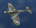
FS2004/FSX Spitfire Mk24
(Category: FSX > Vintage)
16.63Mb (1585 downloads)
FS2004/FSX Spitfire Mk24
The final Spitfire variant, the Mk 24, was similar to the Mk 22 except that it had an increased fuel capacity over its predecessors, with two fuel tanks of 33 gal (150 l) each installed in the rear fuselage. There were also zero-point fittings for rocket projectiles under the wings. All had the larger "Spiteful" tail units: modifications were also made to the trim tab gearings in order to perfect the F Mk 24's handling characteristics. The F Mk 24 achieved a maximum speed of 454 mph (731 km/h), and could reach an altitude of 30,000 ft (9,100 m) in eight minutes, putting it on a par with the most advanced piston-engined fighters of the era. GMAX mdl by A.F.Scrub
Posted Jun 9, 2016 12:19 by A.F.Scrub
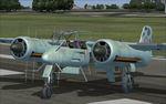

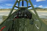
Focke-Wulf Ta 154 Moskito Package
(Category: FS2004 > Vintage)
16.49Mb (1923 downloads)
Focke-Wulf Ta 154 Moskito Package for FS2004. The Focke-Wulf Ta 154 Moskito was a fast twin-engined German night fighter aircraft designed by Kurt Tank and produced by Focke-Wulf during late World War II. Only a few were produced. Kurt Tank's team at Focke-Wulf was a high-wing twin-engined design, built primarily of plywood bonded with a special phenolic resin adhesive called Tego film. The only large-scale use of metal was in the pressurized cockpit. Various prototype models were made and those were used in combat testing in 1945. It had the designation of 'Moskito', as like the very successful British aircraft, it was made of wood, and was hoped to be just as good. Unfortunately due to technological faults the aircraft did not go into series production. Includes opening canopy, VC and 2d panels. By Chris Lampard
Posted Jun 9, 2016 03:44 by uploader
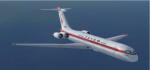
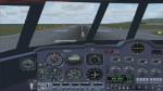
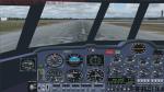
Update for FSX of Il-62M
(Category: FSX > Civil Jets)
11.74Mb (2207 downloads)
This is an update for FSX of the IL-62M by
Dimitri Samborski and repainted by Gergely
Kosa. I have corrected the engine positions
and the contact points, reduced the fuel to
the max the aircraft is supposed to hold;
corrected the airplane_geometry section;
added the rest of the wheels; made a 2D panel
with English gauges, from a picture of the
VC; added a Russian panel from a recent
update of the aircraft; added a smoke effect;
and updated the flight dynamics. No gauges
on the VC.
Posted Jun 8, 2016 10:08 by Bob Chicilo
Update for FS9 of Il-62M
(Category: FS2004 > Civil Jets)
11.74Mb (1032 downloads)
This is an update for FS9 of the IL-62M by
Dimitri Samborski and repainted by Gergely
Kosa. I have corrected the engine positions
and the contact points, reduced the fuel to
the max the aircraft is supposed to hold;
corrected the airplane_geometry section;
added the rest of the wheels; made a 2D panel
with English gauges, from a picture of the
VC; added a Russian panel from a recent
update of the aircraft; added a smoke effect;
and updated the flight dynamics. No gauges
on the VC.
Posted Jun 8, 2016 10:06 by Bob Chicilo
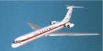
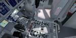
FSX/P3D Boeing 737-800 Miami Air Package
(Category: FSX > Civil Jets)
65.26Mb (1252 downloads)
FSX/P3D TDS Boeing 737-800 Miami Air Package with enhanced VC
Miami Air is a charter airline based at Miami International Airport and operates flights for sports teams, military and private customers. Miami Air currently (2016) operate 5 Boeing 737-800's.
Model by TDS/ Tenkuu Developers Studio
with advanced 737-800 VC added. Includes utility for ground services, Passenger bus, cargo, stairs, refuelling truck etc (find it under - Views - Instrument panel - Util)
The wonderful Boeing 737-800 from TDS will be enjoyed by many more people who do not know how to install a VC into a FSX native model.
The VC is the Alejandro Rojas Lucena/FSND fantastic revised Boeing 737-800 VC model. This VC model includes Working wipers (right mouse click on switch) with rain effect. Switches for LCD Screens, EICAS, PFD, MFT. Autobrake switch. Opening pilots window. Cabin Lights switch. Realistic FMC. Ground Proximity Warning System (GPWS), More Realistic night VC textures. There are custom Boeing 737 sounds included for that extra realism.
I have added the realistic textures by Alejandro Magadan.
Model is not modified in any way. VC added and aircraft.cfg edited to allow correct VC views and jetways.
TDS wonderful native FSX Boeing 737-800 model. See VC docs to get the best out of the VC and FMC.
Assembled and prepared for FSX by Chris Evans.
Posted Jun 8, 2016 06:04 by chris evans

FSX/P3D Boeing B787-9 for AI traffic Model update
(Category: FSX > Civil Jets)
0.83Mb (461 downloads)
FSX/P3D Boeing B787-9 for AI traffic.
B789 MDL update - Version1.1(Note:
This model pack cannot be used in FS9).
Fixed incorrect night lighting and
distortion of belly texture.
Included fixed MDL for both GE and RR.
By Mitsushi Yutaka(FSpainter).
Required files:
required file
Posted Jun 8, 2016 04:22 by uploader
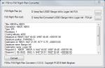
FS9 to FSX Flight Plan Converter
(Category: FSX > Utilities)
0.43Mb (857 downloads)
Flight Plan Converter is a free utility to convert FS9 flight plans to the FSX flight plan format. It support single and batch conversions. Note: FSX can load FS9 flight plans, this utility is intended to help with 3rd party utilities that only support FSX flight plans.
Posted Jun 7, 2016 08:21 by Keith Bingham
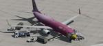
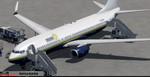
FSX/P3D Boeing 737-800 Nok Air 'Flamingo' Package
(Category: FSX > Civil Jets)
66.30Mb (2695 downloads)
FSX/P3D Boeing 737-800 Nok Air 'Flamingo' Package with enhanced VC
NokAir is a low cost airline based in Thailand and currently (2016) operate 21 Boeing 737-800's with a further 5 on order. Nok Air have many fun liveries - this one being the 'Flamingo' theme.
High detail native FSX model by TDS/ Tenkuu Developers Studio
with advanced 737-800 VC added. Includes utility for ground services, Passenger bus, cargo, stairs, refuelling truck etc (find it under - Views - Instrument panel - Util)
The wonderful Boeing 737-800 from TDS will be enjoyed by many more people who do not know how to install a VC into a FSX native model.
The VC is the Alejandro Rojas Lucena/FSND fantastic revised Boeing 737-800 VC model. This VC model includes Working wipers (right mouse click on switch) with rain effect. Switches for LCD Screens, EICAS, PFD, MFT. Autobrake switch. Opening pilots window. Cabin Lights switch. Realistic FMC. Ground Proximity Warning System (GPWS), More Realistic night VC textures. There are custom Boeing 737 sounds included for that extra realism.
I have added the great textures by Triada Sudarmawan.
Model is not modified in any way. VC added and aircraft.cfg edited to allow correct VC views and jetways.
TDS wonderful native FSX Boeing 737-800 model. See VC docs to get the best out of the VC and FMC.
Assembled and prepared for FSX by Chris Evans.
Posted Jun 7, 2016 04:47 by chris evans
FS Enhancer
(Category: FSX > Utilities)
4.93Mb (1807 downloads)
FSEnhancer is a new standalone Windows software application designed to help Flight Simulator X users to enhance their flying experience.
Some Features:
fsx.cfg File Editor
Cameras.cfg File Editor
Live ATC Chatter
Camera Enhancements for Default Aircraft, including Acceleration package aircraft and the iFly 737 NG Series.
Detailed charts for your chosen airport.
Released under the GNU/GPL License, FS Enhancer is free to use and distribute under the terms of the license, but without warranty.
Click here to Download the latest release.
System Requirements:
Windows 7, 8 and 10
.NET Framework 4.5
2.8 MB Disc Space
Internet Connection
Support is available via the forums at http://www.figerty.net.au/forums/
Posted Jun 6, 2016 02:28 by Dan O'Riordan

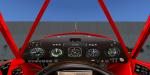
Piper J-3 Cub Updated Package
(Category: FSX > Props)
22.48Mb (2521 downloads)
Default Microsoft FSX Piper J-3 Cub Updated
Complete Aircraft with all available added textures and working radios, with added night lighting, and engine smoke that does not glow at night.
Posted Jun 6, 2016 02:14 by PappaMike