


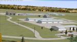
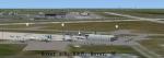
3.60Mb (1462 downloads)
KCBF - Bluffs Municipal Airfield, Iowa, V2.
Modeled after Google Earth images.
All ILS, GPS, and VOR approaches are real world.
With AI traffic. All scenery objects are FSX default except for the apron lights.
Posted Jun 24, 2012 13:29 by T.Marson
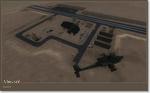
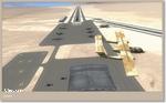
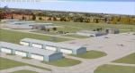
0.01Mb (1059 downloads)
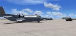
Two fictional military airfields in Death Valley CA. Created with Michael Carr's Military Object Library. (extra file required -- see file for details)
Posted Jun 22, 2012 20:28 by Chuck79
1.31Mb (1223 downloads)
FSX Scenery--Wangen-Lachen Airfield (LSPV), Switzerland. Wangen-Lachen is a small airfield ideal for excursions to the Swiss mountain range on a single or twin engine machine. It's an enhancement of the neglected FSX scenery with mostly standard objects. Needed library is included. Surroundings also realized according to Google satellite imagery. Also adds some marinas, which are there in the real world and help you to line up with the runway but also are a hazard. Also included is boat traffic on the lakes of Zurich with some piers. The scenery is compatible with UTX Europe and FSGUX (Mesh). But since LSPV is pretty flat, the scenery should be compatible with standard mesh too. By Blaunarwal.
Posted Jun 21, 2012 16:53 by Blaunarwal
4.74Mb (706 downloads)
The airport is located 15km west of Kasama the provincial capital city of Northern Province Zambia. It is used commercially by Proflight Zambia but also private.
This photoreal Scenery has been made without adding a FSX default runway. The Runway is bumpy and is not flat at all. Finding the airport shouldn't be a problem. Only Runway 13/31 is used.
FSX only!
Posted Jun 21, 2012 14:58 by Jens Weissflog
1.23Mb (1099 downloads)
Photoreal Scenery of Jeki Airstrip.
The airstrip is located in Zambia at Lower Zambezi National Park and mainly used to bring tourists and game hunters into the park. It is also commercially used by Proflight Zambia.
For FSX only!
Posted Jun 21, 2012 14:23 by Jens Weissflog
49.59Mb (3443 downloads)
Dover Air Force Base package for FSX. Dover AFB is a United States Air Force base located two miles southeast of the city of Dover, Delaware. Dover AFB is home to the 436th Airlift Wing (436 AW) of the Air Mobility Command (AMC), known as the "Eagle Wing", and the AMC-gained 512th Airlift Wing (512 AW) of the Air Force Reserve Command (AFRC), referred to as the "Liberty Wing". It was the only base to solely operate the massive C-5 Galaxy, with two active flying squadrons (the 3rd Airlift Squadron, which now operates the C-17 Globemaster III, and 9th Airlift Squadron) and two Air Force Reserve flying squadrons (the 326th Airlift Squadron and the 709th Airlift Squadron). Just drop and fly. Created to enhance your Flight Sim experience by John B. Loney, Jr.
Posted Jun 17, 2012 12:13 by df

134.75Mb (1248 downloads)
FSX Scenery Ballina Airport, Newq South Wales, Australia. Part 2 of 2 Parts. Ants Aussie Airports 14:Ballina. 1900m RWY with daily B737, A320 and Saab 340 flights. Custom objects, RWY and approach lighting, 100 sq kms of photoreal covering airport, Ballina town and surrounding area. PR works best with ORBX Au installed but will still work with default.By Anthony Lynch.
Posted Jun 15, 2012 19:21 by mike
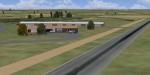
1.57Mb (686 downloads)
This airfield is situated near Pretoria in South Africa and it is used for general aviation training.
Posted Jun 15, 2012 11:13 by Jacques Botha
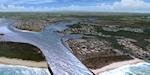
138.23Mb (1316 downloads)
FSX Scenery
Ballina Airport, Newq South Wales, Australia. Part 1 of 2 Parts.
Ants Aussie Airports 14:Ballina.
1900m RWY with daily B737, A320 and
Saab 340 flights. Custom objects,
RWY and approach lighting, 100 sq kms
of photoreal covering airport, Ballina
town and surrounding area. PR works
best with ORBX Au installed but will
still work with default.By Anthony Lynch.
Posted Jun 13, 2012 17:54 by mike
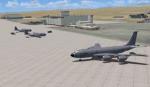
7.21Mb (5462 downloads)
Edwards AFB, California, Ground Additions
This Scenery Addition is an unofficial Update for the Acceleration Pack Edwards AFB Scenery.
It adds 2 Refuel Stations, Static KC-135 Tanker, Static F-15C, Static A-10, Static Predator, Static C-130 Hercules.
Posted Jun 12, 2012 07:54 by uploader