


All Time Popular > Page 2116
CFS2
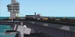
Nuclear aircraft carrier USS John C. Stennis V 1.5
(Category: CFS2 > Scenery)
1.43Mb (1629 downloads)
CFS2
Nuclear aircraft carrier USS John C. Stennis V 1.5. Includes
landable flight deck and working cables for arrestor hook. Now you
can use the new carrier in Combat Flight Simulator 2 and in the mission
editor (this Zip file includes a mission called CVN-74 ). By Javier
Fernandez Additional textures by Dino Cattaneo. 1.5MB
Posted Jun 10, 2008 11:30 by archive
FS2002
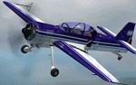
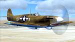
Sukhoi SU-29 Cruz del Sur Aerobatic Team v2.0
(Category: FS2002 > Props)
3.64Mb (1629 downloads)
FS2002
Sukhoi SU-29 Cruz del Sur Aerobatic Team v2.0 The Sukhoi
SU-29 is an incredible high performance two-seat aircraft. Boasting
strength, quickness and maneuverability unmatched, produces
a phenomenal roll rate of over 360 degrees per second. Powered
by a nine cylinder with 360 HP. This version 2.0 upgrade the
original FS2000 SU-29 to FS2002, with high quality textures
of Argentine Air Force Cruz del Sur aerobatic team, realistic
flight dynamics, smoke system, aerobatic carbureter, extra animations,
rolling wheels, functional canopy and pilot head. Package with
sounds, panel and interior views. Sounds by Aaron R. Swindle
(Skysong Soundworks). FSDS model design, textures, flight dynamics
and panel by Ariel Cimino and Cherar Suarez (LatinSim.com).
3.7MB
Posted Aug 24, 2009 06:45 by archive
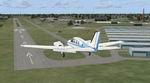
Clearwater FL-Clearwater Airpark (KCLW)
(Category: FSX > Scenery)
0.59Mb (1629 downloads)
Clearwater FL-Clearwater Airpark (KCLW)
This is a complete redo of the default FSX airport with surrounding landclass changes; updated taxiways, aprons and hangers. Also includes library objects and a library of airport buildings. By: Art Poole
Posted May 13, 2009 07:02 by Art Poole
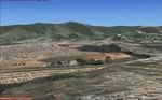
Atibaia Sao Paulo, Brazil Photo Realistic Scenery Part 2.
(Category: FSX > Scenery)
78.14Mb (1629 downloads)
Atibaia Sao Paulo, Brazil Photo Realistic Scenery Part 2.
Revised files for easier download and install.
Atibaia Sao Paulo, Brazil Photo Realistic Scenery. This is part of a scenery package for the area of Sao Paulo by Gilson Rocchetti.
Posted Apr 16, 2009 10:39 by Gilson Rocchetti
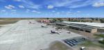

VILK-Lucknow (Amausi)- India
(Category: FSX > Scenery)
20.67Mb (1628 downloads)
Chaudhary Charan Singh Airport (IATA: LKO, ICAO: VILK) is an airport serving Lucknow, the capital of the Indian state of Uttar Pradesh. It is situated in Amausi in the city of Lucknow, and was earlier known as Amausi Airport before being renamed after Chaudhary Charan Singh, the fifth prime minister of India.
Posted Aug 14, 2018 02:06 by Ratan Lewis
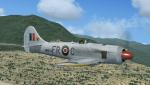
FSX/P3D V3-V4 Hawker Tempest II
(Category: FSX > Vintage)
16.30Mb (1628 downloads)
FSX/P3D V3-V4 Hawker Tempest II
As a result of the termination of the Tornado project, the Tempest II was designed from the outset to use the Bristol Centaurus 18 cylinder radial engine . Apart from the Centaurus engine , the Tempest II prototypes were similar to early series Tempest Vs.Tempest IIs produced during the war were intended for combat against Japan, and would have formed part of a proposed British Commonwealth long-range bomber force based on Okinawa, Tiger Force. The Pacific War ended before they could be deployed. Model by A.F.Scrub
Posted Jun 7, 2018 12:15 by A.F.Scrub
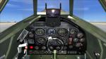
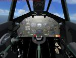
Panel update for the new Supermarine Spitfire by A. F. Scrub
(Category: FSX > Vintage)
6.23Mb (1628 downloads)
This is a panel update for the Supermarine Spitfire Mk VbTrop, recently uploaded by A, F. Scrub. Thanks to him for that terrific model but the panels needed some updating.
New gauges and gauge configuration for both the VC and the 2D panel give them a more detailed appearance and the VC has been entirely newly designed. New VC and gauge configuration by Michael Pook.
Required files:
required file
Posted Apr 16, 2018 11:17 by Michael Pook
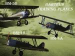
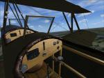
FSX/P3D Bartel Training Aircraft Package (upg)
(Category: FSX > Vintage)
61.69Mb (1628 downloads)
Package contains 3 FSX native aircraft. The Bartel BM-4a, BM-4h and BM-5d trainer was a Polish biplane aircraft,
the first plane of Polish design put into production.
Used from 1929 to 1939 by the Polish Air Force,manufactured in the Wielkopolska Aircraft Factory WWS "Samolot" in Poznan.
All Bartel training aircrafts had very good handling, high stability and the total spin resistance,
provide high security in primary training.
Aircraft constructed from wood, canvas and aluminum characterized by interchangeability of the upper
and lower wings and the standardization of parts and materials.
The airplane reproduced on the basis of drawings and photos.
As far as the documentation allowed equipment of the cockpits is fully reconstructed. The add-on is compatible with FSX Acc and P3D v2 (should also work in later versions)
By Rob Kowalski from FlyFreeStudio.
Posted Nov 27, 2015 08:49 by Rob Kowalski
Boeing 707 2d Panel
(Category: FS2004 > Panels)
4.96Mb (1628 downloads)
Based on another designer's BMP background. I changed the engine gauges to be more correct, added softer lighting, added a Nav/GPS switch and added autosmoke when engine N1 is above 75%. Also included a darker thicker smoke effect.
Posted Jul 9, 2014 01:40 by William L.
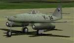
CFS/FS2000
Avia S-92 (Me-262A-1a) with panel & sound files
(Category: CFS1 > Aircraft)
2.83Mb (1628 downloads)
CFS/FS2000
Avia S-92 (Me-262A-1a) with panel & sound files. Avia
S-92 was the postwar version of Messerschmitt Me-262 Schwalbe, used
by Czechoslowak Air Force. Moving parts, transparent canopy, sound
and panel. Design: Bernd Drefahl. Panel, sound: ABACUS, Gauges:
Stefan Geissler. Repaint, completation for CFS/FS2000: Tibor Stilz.
2.9MB
Posted Jun 10, 2008 11:32 by archive