


All Time Popular > Page 2593
FSX/2004
Curtiss C-46A Commando BRANIFF Textures only
(Category: FSX > Vintage)
1.71Mb (1236 downloads)
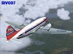
FSX/2004
Curtiss C-46A Commando BRANIFF Textures only in BRANIFF
livery for the new and beautiful Libardo Guzman/CalClassic's
Curtiss C46A Commando (here).
Repaint by Manuele Villa. 1.7MB
Posted Jun 23, 2008 14:16 by archive
FS2000/2002
Mirage 2000B of the French Armée de l'Air.
(Category: FS2000 > Military)
0.58Mb (1236 downloads)
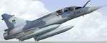
FS2000/2002
Mirage 2000B of the French Armée de l'Air. Modified to a
two-seat trainer version and armed with early style wing tanks
and Matra Magic missiles. Base Mirage 2000 aircraft by Oxyd.
Visual model modified by Denis da Silva Oliveira and Daniel
da Silva Oliveira. Textures modified by Frank Safranek. 599K
Posted Jun 23, 2008 14:36 by archive
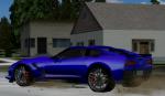
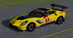
FSX/Acceleration/FS2004/P3d3.5 Package Chevrolet Corvette C7
(Category: FSX > Misc)
24.87Mb (1235 downloads)
FSX/Acceleration/FS2004/P3d3.5 Package Chevrolet Corvette C7 "Stingray" sport and racing car. The 2014 Chevrolet Corvette C7 (seventh generation) is the first to bear the name "Stingray" since the third generation 1968 model. The package contains models for the default street car and a racer; each model with different cockpits and both versions in five colours. The FSDS 3.5 models with panels and base colours in default red and the yellow racer are made by Erwin Welker. All other repaints, realistic special C7 gauges and special light effects are made by Pierre Carosin.
Posted Feb 15, 2018 05:31 by Erwin Welker
FSX Airbus A321 Thomas Cook textures
(Category: FSX > Civil Jets)
3.48Mb (1235 downloads)
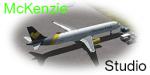
Thomas Cook T-TCCD textures for the default FSX Airbus A321. Thomas Cook is a UK leisure airline. The A321 is the mainstay of it's fleet with 21 in operation in 2016. Textures by Declan McKenzie
Posted Aug 18, 2016 08:07 by Declan McKenzie
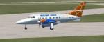
FSX Proflight Commuter Services,Zambia, Bae Jetstream 32 for A.I
(Category: FSX > Props)
0.62Mb (1235 downloads)
FSX Proflight Commuter Services,Zambia, Bae Jetstream 32 for A.I. This aircraft is used by Proflight Commuter Services for domestic schedule services in Zambia.
Posted Jan 21, 2012 12:16 by Bashir Ismail
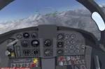
IRIS F-5 Superpack FSX Conversion Panel only
(Category: FSX > Military)
4.81Mb (1235 downloads)
This file converts the FS2004 version. It is not required if you have the FSX version below! IRIS F-5 Superpack panel only. This file will update the FS2004 IRIS F-5 Superpack so the panel will work in FSX. This is for those who already have the FS2004 version and you don't want to download the whole package again. This fixes the panel so all gauges will work and you will get no warnings in the VC and 2d panel. Updated by Danny Garnier
Required files:
required file
Posted Dec 18, 2010 10:57 by GARNIER D
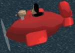
Gromit's
Plane for fs98/2000
(Category: FS2000 > Misc)
0.03Mb (1235 downloads)
Gromit's
Plane for fs98/2000 by Chris Cooper Gromit's sidevar/plane
from the Wallace & Gromit movie 'A Close Shave' Features
high accuracy modelling and realistic texturing. Fully compatible
with both fs98 and 2000. 29K
Posted Jun 23, 2008 14:36 by archive
FS2004
AFCAD Scenery for EDXW ,Flugplatz Westerland-Sylt , Schleswig-Holstein
,Germany
(Category: FS2004 > Scenery)
0.39Mb (1235 downloads)
FS2004
AFCAD Scenery for EDXW ,Flugplatz Westerland-Sylt , Schleswig-Holstein
,Germany
By: Frank Böhrnsen Enables AI ( Artificial Aircraft in FS 2004
) to approach and depart from EDXW. Now you can insert EDXW
in your own Flightplans for FS 2004. 401K
Posted Jun 23, 2008 14:25 by archive
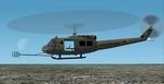
Bell
UH-1H "Left Bank"
(Category: FS2002 > Helicopters)
1.31Mb (1235 downloads)
Bell
UH-1H "Left Bank" Special Electronic Mission aircraft for
Microsoft FS 2002 Standard and Pro Editions. Full package. Original
aircraft by Jordan Moore. The "Left Bank" Hueys were used during
the Vietnam War to locate and identify enemy radio transmitters.
This aircraft depicts "The Good", as flown by the 371st Radio
Research Company, 1st Cavalry Division. Jim Bennett. 1.4MB
Posted Jun 23, 2008 14:34 by archive
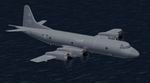
FS
2004 CAF CP-140 Lockheed Aurora New Colours Textures
(Category: FS2004 > Military)
0.16Mb (1235 downloads)
FS
2004 CAF CP-140 Lockheed Aurora New Colours Textures
for Mike Stone's P-3 Orion in the colour scheme of Canadian
Armed Forces CP-140 Aurora, 407 Squadron, CFB Comox c.2002.
Requires Mike's original file here.
Textures by Geoff Chambers. 167K
Posted Jun 23, 2008 14:27 by archive