


All Time Popular > Page 3628
FS2004
Flight PLan AL Extreme Flight 01
(Category: FS2004 > Misc)
0.05Mb (675 downloads)
FS2004
Flight PLan AL Extreme Flight 01
Flight plan for the flight Rio Amazonas in Ecuador to Simon
Bolivar Intl Airport. Warning, Rio Amazonas is located to one
old crater!. Use the default King-Air 350. By Jean-Jacques Parel.
54K
Posted Jun 23, 2008 14:27 by archive
De
Havilland Canada DHC-3 Otter Panel.
(Category: FS2002 > Panels)
2.62Mb (675 downloads)
De
Havilland Canada DHC-3 Otter Panel.
João Paz. 2.7MB
Posted Jun 23, 2008 14:32 by archive
FS2000
New York World Trade Center.
(Category: FS2000 > Scenery)
0.05Mb (675 downloads)
FS2000
New York World Trade Center. A
rough work of one of the proposed NYC World Trade Center developments.
Just a simple model but no texture since that's not existing
at this moment. Designed by: Elvis Ghaw. 52K
Posted Jun 23, 2008 14:35 by archive
Milan
Malpesa 2000
(Category: FS2000 > Scenery)
1.03Mb (675 downloads)
Milan
Malpesa 2000 - revised version for this airport. File
size 1705197. R Fiore
Posted Jun 23, 2008 14:35 by archive
FS2002,
St. Kitts International Airport, Island of St. Kitts, Caribbean
Region
(Category: FS2002 > Scenery)
3.59Mb (675 downloads)
FS2002,
St. Kitts International Airport, Island of St. Kitts, Caribbean
Region.TKPK
By: Bill Melichar Description: This scenery depicts the Robert
L. Bradshaw International airport on the Island of St. Kitts
in the Caribbean. It contains the modern new terminal, along
with the distinctive green glass tower, and outer buildings.
It is a small airport which is located in a valley between two
mountain ranges near the southern end of the Island. This location
is best run with a terrain mesh of the area, and land class
scenery of the Caribbean, since FS has sadly neglected it in
this respect. I have included several smaller mountains which
will hide under the terrain mesh to enhance the location for
those who do not have the terrain mesh installed.3.7MB
Posted Jun 23, 2008 14:31 by archive
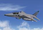
FS2002 / FS2004 Jaguar GR3, XX112, John Sullivan's (OC 6Sqn) Textures only.
(Category: FS2004 > Military)
0.71Mb (675 downloads)
FS2002
/ FS2004 Jaguar GR3, XX112, John Sullivan's (OC 6Sqn) Textures
only.
This repaint requires the Freeware Alphasim RAF Jaguar Package
(here).
Repaint by Andy Nott (AGN Textures). 725K
Required files:
required file
Posted Jun 23, 2008 14:27 by archive
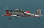
THE
COMPLETE CHIPMUNK COLLECTION (PART 4) - Royal Navy Chipmunk
(Category: FS2000 > Props)
2.84Mb (675 downloads)
THE
COMPLETE CHIPMUNK COLLECTION (PART 4) - Royal Navy Chipmunk
This package contains the last part of four different aircraft
in the THE COMPLETE CHIPMUNK COLLECTION FOR FLIGHT SIMULATOR
2000, the Royal Navy Chipmunk. The model has full moving parts,
two pilots, detailed cockpit and a virtual cockpit. This package
also includes a complete panel for the aircraft, as well as
checklists and notes for FS pilots. All default gauge files
are included. Sound is aliased to the default FS 2K Cessna 182.
As alternatives, the FS 2K Supercub sound package by Aaron R.
Swindle (sprkubsn.zip) or the FS 98 Magister sound package by
Mike Hambly (mag1.zip) are available from this site and recommended.
All aircraft in this collection are completely new FSDS designs
and include realistic flight dynamics by Dennis Seeley. Visual
design and panel by Graham P. Oxtoby. 2.9MB
Posted Aug 24, 2009 06:46 by archive
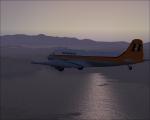
Bonanza Airlines DC-3 Textures
(Category: FSX > Vintage)
2.30Mb (675 downloads)
Bonanza Airlines textures for the FSX default DC-3 aircraft by Microsoft/Aces and modified James Eden and Jon Murchison.
These textures require AWESUM4SUM.zip modification to the default FSX DC-3
Textures by Gary Harper.
Required files:
required file
Posted Aug 23, 2010 21:30 by Gary Harper
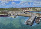
Ouessant addon for France VFR
(Category: FSX > Payware)
6.94Mb (675 downloads)
This scene has been made as a complement for France FVR Bretagne FSX + also creation Brittany Lighthouses payware. Both excellent.
It covers extensively the island of Ouessant and add stuff to ile de Sein and Ile of Molene. (more than 1000 non generic detailed objects added, some of them stupidly highly detailed, still a concerted effort was made not too affect the FPS)
Missing lighthouses after the Alro addon have been added too.
Just copy and paste the scenery and texture folders the usual way, then declare the scene. It should have a higher Priority than France VFR FSX Bretagne and Alro's Lighthouses.
Posted May 10, 2010 01:15 by Etienne V
FSX Hurghada-HEGN, Egypt
(Category: FSX > Scenery)
54.96Mb (674 downloads)
Well it starts as always, I can't find a usable freeware airport in this casefor the
airport Hurghada HEGN, Egypt, so I'll build it myself again.
Well what can I say here it is as real as possible with many details with the after a
lot of work Standard Scenery built.
So fly to Hurghada in Egypt, have a look with a helicopter overdrivable car shows
the many details, the hotel beaches with people, the maintenance hall whose gate
opens when you roll towards the Bedouin village or the port just have fun and go
on your journey .........
Installation:
Copy the folder FSX Hurghada Scenery into the Addon folder of the FSX,
the FSX start to settings, switch to scenery library, add area,
press OK,after that you canstart .............
Extras
to be able to see people I deliver the file 3DPeoble_Lib with this you can also in
Copy the addon folder and activate it in FSX as described during installation and
you already see people ..............
the same applies to extra vehicles with the supplied file ObjLib-Large-CarParking FSX and you can already see more vehicles ..........
! You don't need these extras if you already have them!
https://www.youtube.com/watch?v=6fa8fkfunRA
Support:
Questions and help on my YouTube channel or by email at
jam_aika@hotmail.de now have fun in Egypt
LG Jamaika
Posted Jan 11, 2022 02:48 by Ewald Wagner alias Jamaika